In this article, You will read Temperate Cyclone (Mid Latitude Cyclone or Extratropical cyclones or Frontal Cyclones) – for UPSC IAS (Geography).
Before reading this article, You must read the concept of Airmass and Fronts.
Temperate Cyclone
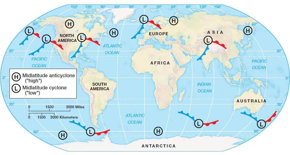
- Temperate cyclones are storm systems emerging in the mid and high latitudes, away from the tropics, and They are low-pressure systems with associated cold fronts, warm fronts, and occluded fronts.
- The systems developing in the mid and high latitude (35° latitude and 65° latitude in both hemispheres), beyond the tropics are called the Temperate Cyclones or Extra-Tropical Cyclones or Mid-Latitude Cyclones or Frontal Cyclones or Wave Cyclones.
Origin and Development of Temperate Cyclones
Polar Front Theory
- According to this theory, the warm-humid air masses from the tropics meet the dry-cold air masses from the poles and thus a polar front is formed as a surface of discontinuity.
- Such conditions occur over sub-tropical high, sub-polar low pressure belts and along the Tropopause.
- The cold air pushes the warm air upwards from underneath. Thus a void is created because of lessening of pressure. The surrounding air rushed in to occupy this void and coupled with the earth’s rotation, a cyclone is formed which advances with the westerlies (Jet Streams).
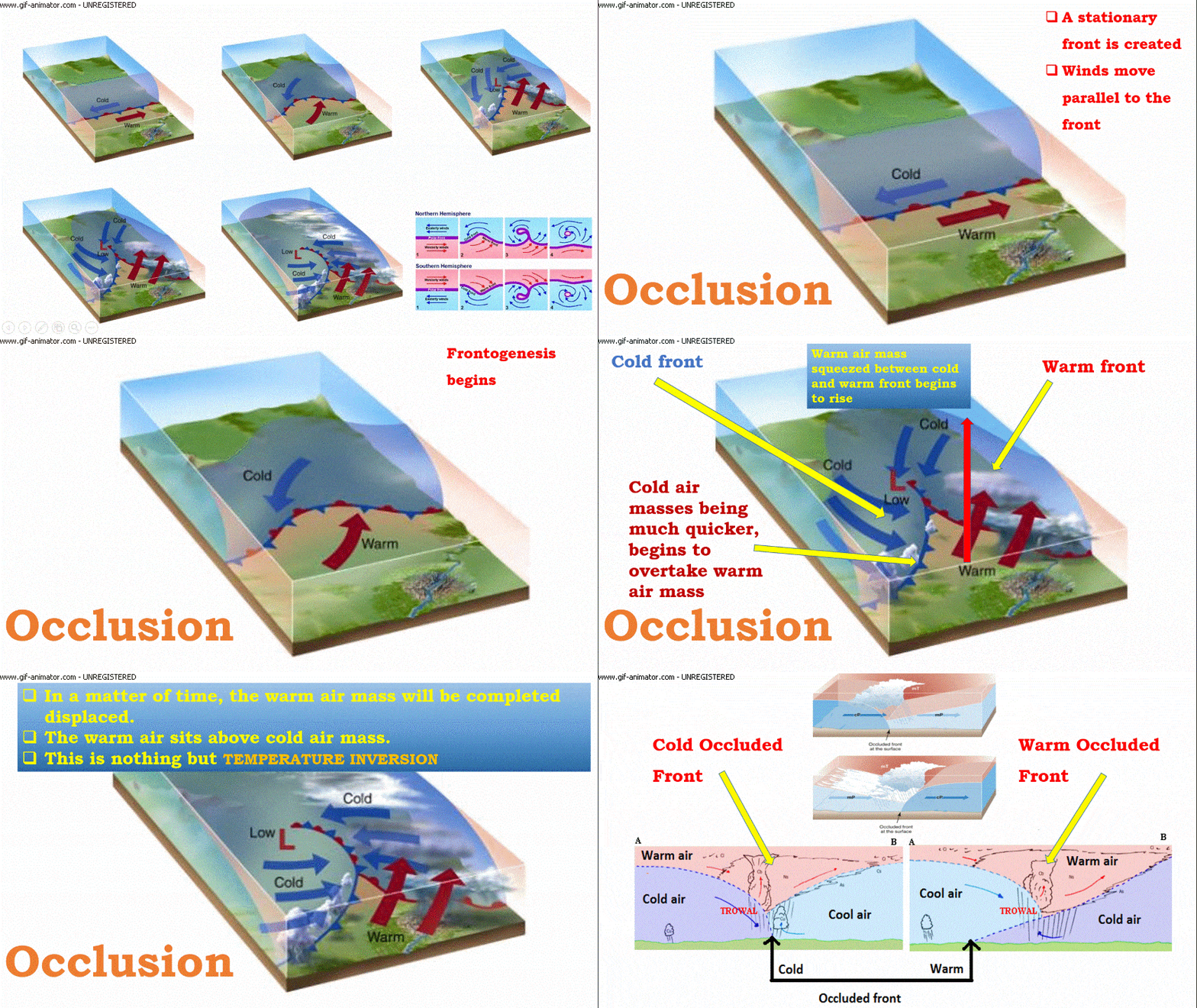
- In the northern hemisphere, warm air blows from the south and cold air from the north of the front.
- When the pressure drops along the front, the warm air moves northwards and the cold air move towards the south setting in motion an anticlockwise cyclonic circulation (northern hemisphere). This is due to Coriolis Force.
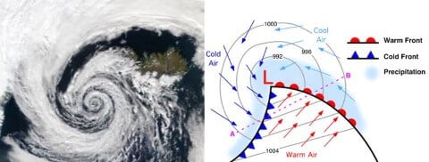
- The cyclonic circulation leads to a well-developed extratropical cyclone, with a warm front and a cold front.
- There are pockets of warm air or warm sector wedged between the forward and the rear cold air or cold sector. The warm air glides over the cold air and a sequence of clouds appear over the sky ahead of the warm front and cause precipitation.
- The cold front approaches the warm air from behind and pushes the warm air up. As a result, cumulus clouds develop along the cold front. The cold front moves faster than the warm front ultimately overtaking the warm front. The warm air is completely lifted up and the front is occluded (occluded front) and the cyclone dissipates.
- The processes of wind circulation both at the surface and aloft are closely interlinked.
- So temperate cyclone is intense frontogenesis involving mainly occlusion type front. (Occluded front explained in detail in previous posts).
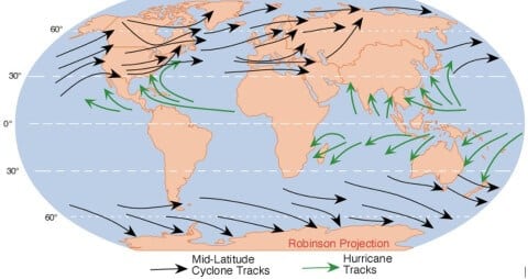
- Normally, individual frontal cyclones exist for about 3 to 10 days moving in a generally west to east direction.
- The precise movement of this weather system is controlled by the orientation of the polar jet stream in the upper troposphere.
Seasonal Occurrence of Temperate Cyclones
- The temperate cyclones occur mostly in winter, late autumn and spring. They are generally associated with rainstorms and cloudy weather.
- During summer, all the paths of temperate cyclones shift northwards and there are only few temperate cyclone over sub-tropics and the warm temperate zone, although a high concentration of storms occurs over Bering Strait, USA and Russian Arctic and sub-Arctic zone.
Distribution of Temperate Cyclones
- USA and Canada – extend over Sierra Nevada, Colorado, Eastern Canadian Rockies and the Great Lakes region,
- the belt extending from Iceland to Barents Sea and continuing over Russia and Siberia,
- winter storms over Baltic Sea,
- Mediterranean basin extending up to Russia and even up to India in winters (called western disturbances) and the Antarctic frontal zone.
Characteristics of Temperate Cyclones
Size and Shape
- The temperate cyclones are asymmetrical and shaped like an inverted ‘V’.
- They stretch over 500 to 600 km.
- They may spread over 2500 km over North America (Polar Vortex).
- They have a height of 8 to 11 km.
Wind Velocity And Strength
- The wind strength is more in eastern and southern portions, more over North America compared to Europe.
- The wind velocity increases with the approach but decreases after the cyclone has passed.
Orientation And Movement
- Jet stream plays a major role in temperate cyclonogeneis.
- Jet streams also influence the path of temperate cyclones.
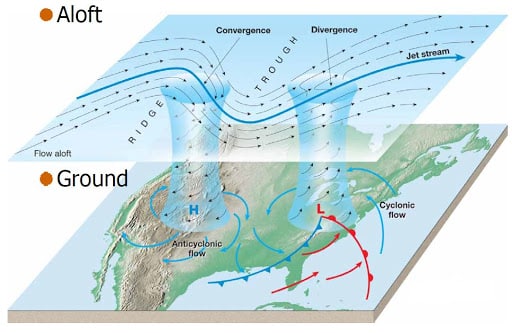
- Since these cyclones move with the westerlies (Jet Streams), they are oriented eastwest.
- If the storm front is east-west, the center moves swiftly eastwards.
- If the storm front is directed northwards, the center moves towards the north, but after two or three days, the pressure difference declines and the cyclone dissipates.
- In case the storm front is directed southwards, the center moves quite deep southwards-even up to the Mediterranean region [sometimes causing the Mediterranean cyclones or Western Disturbances (They are very important as they bring rains to North-West India – Punjab, Haryana)].
Structure
- The north-western sector is the cold sector and the north-eastern sector is the warm sector (Because cold air masses in north and warm air masses in south push against each other and rotate anti-clockwise in northern hemisphere).
Associated Weather
- The approach of a temperate cyclone is marked by fall in temperature, fall in the mercury level, wind shifts and a halo around the sun and the moon, and a thin veil of cirrus clouds.
- A light drizzle follows which turns into a heavy downpour. These conditions change with the arrival of the warm front which halts the fall in mercury level and the rising temperature.
- Rainfall stops and clear weather prevails until the cold front of an anticyclonic character arrives which causes a fall in temperature, brings cloudiness and rainfall with thunder. After this, once again clear weather is established.
- The temperate cyclones experience more rainfall when there is slower movement and a marked difference in rainfall and temperature between the front and rear of the cyclone. These cyclones are generally accompanied by anticyclones.

0 Comments