Climate is a measure of the average pattern of variation in temperature, humidity, atmospheric pressure, wind, precipitation, atmospheric particle count, and other meteorological variables in a given region over long periods of time.
Any independent study of each of these elements does not present any comprehensive view of climate. On the basis of these elements, there could be thousands of types of climates in the world.
Weather & Climate
Weather
- Weather, state of the atmosphere at a particular place during a short period of time. It involves such atmospheric phenomena as temperature, humidity, precipitation (type and amount), air pressure, wind, and cloud cover.
- The weather differs from the climate in that the latter includes the synthesis of weather conditions that have prevailed over a given area during a long time period – generally 30 years.
- Weather, as most commonly defined, occurs in the troposphere, the lowest region of the atmosphere that extends from the Earth’s surface to 6–8 km (4–5 miles) at the poles and to about 17 km (11 miles) at the Equator.
- Weather is largely confined to the troposphere since this is where almost all clouds occur and almost all precipitation develops. Phenomena occurring in higher regions of the troposphere and above, such as jet streams and upper-air waves, significantly affect sea-level atmospheric-pressure patterns – the so-called highs and lows – and thereby the weather conditions at the terrestrial surface.
- Geographic features, most notably mountains and large bodies of water (e.g., lakes and oceans), also affect weather.
- Recent research, for example, has revealed that ocean-surface temperature anomalies are a potential cause of atmospheric temperature anomalies in successive seasons and at distant locations. One manifestation of such weather-affecting interactions between the ocean and the atmosphere is what scientists call the El Niño/Southern Oscillation (ENSO).
Climate
- Climate, conditions of the atmosphere at a particular location over a long period of time; it is the long-term summation of the atmospheric elements (and their variations) that, over short time periods, constitute weather.
- These elements are solar radiation, temperature, humidity, precipitation (type, frequency, and amount), atmospheric pressure, and wind (speed and direction).
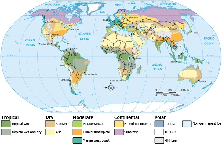
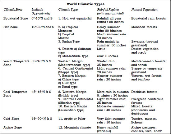
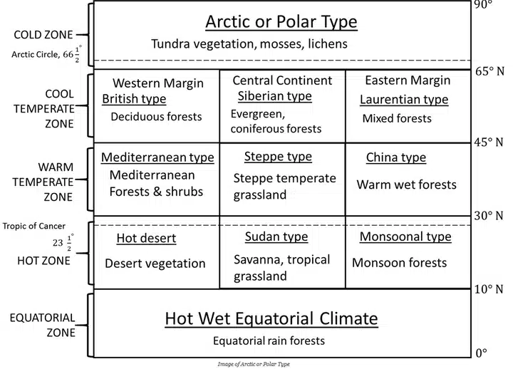
Climatic Regions of World
Hot, Wet Equatorial Climate
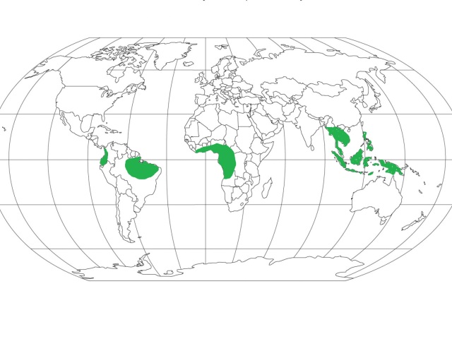
Distribution
- 50 North – 100 South from equator
- No impact of trade winds, if you go away from this will have monsoon type climate.
- Basically, hot, wet type of climate but also have cool places like Cameron highland in Malaysia because these places are at high altitude.
- Examples of some Countries: Ecuador, Colombia, Brazil, Peru, Nigeria, Liberia, Myanmar, Thailand, Cambodia, Malaysia, Java
Climate
- There is great uniformity of temperature throughout the year.
- The mean monthly temperatures are always around 24 to 27ºC, with very little variation.
- There is no winter.
- The diurnal and annual range of temperature is small.
- Precipitation is heavy between 6o inches and 10 inches, and well distributed throughout the year.
- The double rainfall peaks, coinciding with the equinoxes are a characteristics feature of it.
Natural Vegetation
- It support a luxuriant type of vegetation – the tropical rain forest.
- Amazon tropical rain forest is known as Selvas.
- It comprises a multitude of evergreen trees that yield tropical hardwood, e.g. mahogany, ebony, greenheart, cabinet wood. And dyewoods.
- Lianas, epiphytic and parasitic plants are also found.
- Trees of single species are very scarce in such vegetation.
Economy
- The equatorial regions are generally sparsely populated.
- In the forests, most primitive people live as hunters and collectors and the more advanced ones practice shifting cultivation.
- Some plantation crops are also practiced like natural rubber, cocoa, etc.
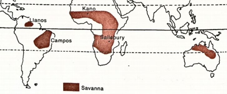
Savanna or Sudan Climate (or Tropical Wet and Dry Climate)
- Savanna or Sudan climate is a transitional type of climate found between the equatorial forests & trade wind hot deserts.
- It is confined within the tropics (Tropic of Cancer & Tropic of Capricorn) & is best developed in Sudan, where dry & wet climate are most distinct, hence named Sudan climate.
- It covers much of Africa (Keya, Nigeria, Gambia) as well as large areas of Australia, South America (Brazilian highlands), and India.
- Savana Climate has a distinct dry season which occurs in winter. All the rainfall in the region is concentrated during the summer. The long dry season causes many plants to die and streams to dry, which causes migration of animals.
Distribution
- It is situated within the tropical latitudes on either side of the equator. It is well developed in Sudan, and hence the name, where there are distinct wet and dry seasons.
- In the northern hemisphere, this climate is found in Africa (African Sudan, East Africa), and South America (Llanos grasslands of Orinoco river basin).
- In the southern hemisphere, this climate is spread through South America (Campos grasslands of the Brazilian Highlands), and Australia (in Northern Australia – south of its monsoon strip).
Temperature
- Monthly temperatures in this region can range between 20 to 32 degrees centigrade for lowlands, but the range increases as one moves away from the equator.
- Annual average temperature is around 18 degrees centigrade
- The highest temperature occurs just before the onset of the rainy season i.e., April in the northern hemisphere, and October in the southern hemisphere. June, when the summer solstice occurs in the northern hemisphere, does not witness the highest temperature.
- During the rainy season, overcast in the sky leads to drop in the temperatures.
- During the hot season, noon temperatures often cross 37 degrees centigrade.
- Clear skies lead to rapid radiation loss in the night and even in the hot season, the temperatures drop to below 10 degrees centigrade. Night frost is a common occurrence during this season
- Thus, a typical characteristic feature of Savanna climate is the extreme diurnal range of temperature.
Precipitation
- The region is characterized by a hot, rainy season and cool, dry season.
- In the northern hemisphere, the hot and wet season starts in May and continues until September (e.g., Kano, in Nigeria). The rest of the year is dry and cool. Kano, which is located at an altitude of over 1500m above mean sea level, experiences over 80 cm of rainfall which happens mostly in the summer.
- In the southern hemisphere, the rainy season begins in October and ends in March.
- The length of the rainy season, as well as the total annual rainfall, decrease considerably as one moves away from the equator towards the desert fringes.
Winds
- Trade-winds are the prevailing winds of the region which bring rainfall in the coastal areas. They are easterly winds – flow from east to west, hence the rainfall is maximum on the east coasts
- They are the strongest in summer when the ITCZ is positioned over the hot desert. They exhaust all the moisture while travelling over the coastal areas and by the time they reach the continental interiors, they are relatively dry.
- In West Africa, the easterly trade winds blow off-shore bringing dust-laden, dry winds from the Sahara and reach the coast of Guinea. The local name for this hot, dry, dusty wind is Harmattan (meaning ‘the doctor’).
- Harmattan has a disastrous effect on the crops, but it also results in a cooling effect. It provides some relief from the damp air of Guinea by increasing the rate of evaporation.
- Trade-winds are the reason for distinct, alternate dry and wet seasons in the region. In summer, onshore trade winds bring moisture-laden winds causing rainfall. In winter, the winds are off-shore and keep the weather dry.
Vegetation
- The typical vegetation of this region is tall grass with short trees. The grassland is also described as ‘bush-veld’ or ‘parkland’.
- Tree cover is the highest towards the equator, along with the river banks and decreases in density and height away from the equator.
- The trees are of the deciduous variety i.e., they shed their leaves during the dry and cool season in order to prevent transpiration losses. Acacia is a typical example of this variety.
- Other types of trees include those with broad trunks which act as water-storage spaces that help them survive the dry season or drought. E.g., baobabs, bottle trees etc.
- They are hardwood trees, sometimes thorny, which exude gum like the ‘gum arabic’.
- The grass found in this region is very tall and coarse, reaching heights of up to 6-12 feet. Elephant grass, which is the tallest variety of grass, can even reach heights of 15 feet.
- The grass is compact, with long roots that reach down in search of water. During the dry season, the grass appears dormant and springs up during the rainy season.
- As one moves towards the desert, the grasslands eventually merge into thorny scrubs.
Wildlife
- Savanna is home to some of the largest terrestrial animals on this planet.
- The two main groups of animals include – herbivores and carnivores.
- Famous herbivores of savanna are zebra, giraffe, elephant, antelope etc. The herbivores are either endowed with great speed to run away or have camouflage skills to escape the carnivores
- Important carnivores of this region include lion, hyena, leopard, panther, puma, jaguar etc. They have powerful jaws and teeth for attacking other animals.
- Along the rivers and marshy lands, one can find reptiles like crocodiles, monitors, giant lizards apart from rhinos and hippos.
Economy
- The region has nomadic pastoralists such as the Masai, who are found in Kenya and Tanzania of Africa. They are dependent on their animal stock for their survival and lead a primitive lifestyle.
- Settled agriculture is also practised by many tribes such as the Hausa, who have also domesticated animals for their use in crop cultivation
- Plantation agriculture which is developed in northern Australia, eastern Brazil, and in central Africa is indicative of the immense agricultural potential of this region. Crops such as cotton, sugarcane, oil palm, groundnuts, coffee, and tropical fruits are cultivated.
- Small amounts of millets, bananas, and vegetables are also cultivated by the tribes for self-consumption.
- However, frequent droughts pose a risk to crop cultivation in the region, particularly in the long dry season.
- In many areas, intense rainfall during the rainy season led to leaching of topsoil and the nutrients like nitrates, phosphates, and potash. Hence, the soils have turned lateritic in many places, incapable of supporting crop cultivation
- The grass here is of poor quality and does not favour large-scale animal ranches which are found in the temperate grasslands. Hence, meat and dairy production are poor from this region.
- However, some regions have leveraged modern science and technology and have become leading exporters of meat and dairy products. For instance, Queensland of Australia.
Tropical Monsoon Climate
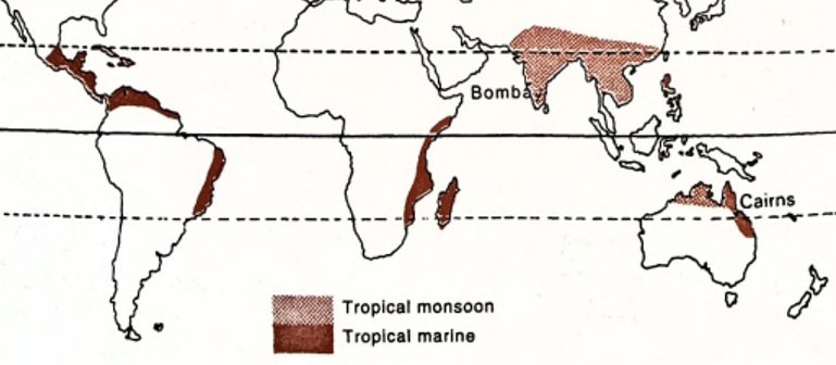
- Monsoon climate, also known as the tropical monsoon climate, is found in the region bounded by the Tropic of Cancer and the Tropic of Capricorn.
- The region is influenced by the movement of the inter-tropical convergence zone (ITCZ) and is hot and humid all around the year because the sun remains overhead.
- Monsoons are seasonal winds, blowing over the landmasses from the seas and vice-versa.
- They are characterized by a seasonal reversal in the wind direction, leading to variations in temperature and precipitation.
- Summer, winter, and rainy seasons are the three prominent and distinct seasons of this climatic region.
Distribution
- They are confined within 5 – 30 degrees latitudes on either side of the equator.
- Indian subcontinent, Indo-China (Laos. Vietnam, Cambodia), Thailand. southern China and northern Australia are the regions experiencing this climate.
Winds
- The seasonal reversal in the direction of winds is an outcome differential rate of heating and cooling of the continental landmasses and seawaters.
- During the summers, a low-pressure region develops over Central Asia as the sun comes overhead the Tropic of Cancer. This causes the Asian landmass to heat up faster than the surrounding seas, which remain at a higher pressure in the northern hemisphere.
- In the southern hemisphere, winter conditions prevail, leading to a high-pressure zone over northern Australia.
- Winds blow outward from the Australian landmass towards Java (Indonesia) and are drawn towards the low-pressure region over the Indian subcontinent after crossing the equator, under the influence of the Coriolis force. These are the South-West monsoon winds.
- During winters, a reversal in the wind direction occurs.
Temperature
- Owing to the region’s proximity to the tropics, it experiences warm to hot summers.
- Average monthly temperature is above 18 degrees centigrade, but in summers the maximum can reach as high as 45 degrees centigrade.
- The average temperature in the summer is around 30 degrees centigrade, with an overall temperature range of 30 to 45 degrees centigrade.
- Winters are mild with a temperature range of 15 to 30 degrees centigrade. Mean temperature during winters is around 25 degrees centigrade.
Precipitation
- The region experiences very high rainfall, which is concentrated in a few months.
- Annual average rainfall is around 200-250 cm. However, some regions have a very high average of around 350 cm.
- In India, Maysynram and Cherrapunji of Khasi Hills (Meghalaya) experience an annual rainfall of over 1000cm. They are located on the windward side of the hills, causing heavy orographic rainfall (caused by a lift of the monsoon winds). Due to the location in between mountains which causes a concentration of rain-bearing clouds, also known as the funnelling effect, these places receive very high rainfall.
Seasons
Unlike the equatorial climate which does not have distinct seasons, monsoon climate experiences striking differences in weather conditions based on the seasons.
- The hot dry season
- This lasts from March to mid – June.
- The sun is in a northward shift to the Tropic of Cancer. This causes the temperatures to rise sharply.
- Mean temperatures during the day cross 35 degrees centigrade in Central India. It can reach as high as 44 degrees centigrade in Sindh and also in south India.
- In coastal areas, the temperatures are not so high, due to the influence of sea breezes.
- Except for the occasional thunderstorms, there is little rainfall during this season.
- The rainy season
- This lasts from mid – June to September
- The rains begin with the ‘burst’ of monsoon over the subcontinent. It results in torrential rainfall throughout the country.
- Over 70 percent of the rainfall which the country receives in a year occurs in this season.
- This can be termed a typical characteristic feature of monsoon type of climate i.e., concentrated heavy rainfall during the summer months.
- The cold dry season
- This season begins in October and lasts until February.
- Also known as the season of retreating monsoon. As the sun begins its southward shift, south-west monsoon begins to retreat southwards until it leaves the Indian landmass completely.
- The temperatures over the landmass begin to fall creating a high-pressure region over Indian subcontinent compared to the surrounding seas. This causes the winds to blow away from the landmass towards the sea.
- The winds begin to blow from the northeast direction over the Bay of Bengal and cause some rainfall along the south-east coastal landmass of India in the months of November and December.
- In the north, the Western Disturbances bring some amount of rain and snow, otherwise, the region remains dry. Frontal (cyclonic) rainfall due to the western disturbances is essential for the survival of winter crops.
Monsoon Forests
- Also known as the Tropical Monsoon Forests.
- These are mostly the trees of deciduous variety – they have a distinct season for the shedding of leaves. They shed their leaves during the dry/drought season to prevent transpiration losses.
- They can be of two types – moist deciduous, where the rainfall exceeds 150cm, and dry deciduous where the average annual rainfall is less than 150cm.
- They are made up of broad-leaf hardwood trees, similar to the equatorial rainforests. But the forests are not as dense, and they are more open with less diversity of species (flora as well as fauna).
- Wherever the rainfall exceeds 200-250cm, evergreen rainforests of the equatorial type can be found. These are prominent in the southern Western Ghats, forests in the northeast, Andaman and Nicobar islands of India. They are also found in the islands of southeast Asia.
- Wherever the rainfall is scanty, savanna type grasslands are found with scattered trees.
- Hence, monsoon vegetation shows a great variation from dense forests to thorny scrublands (savanna).
Economy
- These regions have a high population density.
- Subsistence agriculture is the main type of crop cultivation, although shifting cultivation and plantation agriculture is also practised.
- In the plains of north India, cereals like rice, wheat, maize etc. are cultivated apart from jute, sugarcane, and spices.
- In the highlands of south and east India, plantation crops can be found – tea, coffee, rubber, banana etc
- Lumbering is an important activity with the forest yielding durable hardwood. Teak is an important deciduous timber variety found in central India as well as in Myanmar. Other timber varieties include Sal, Acacia, Eucalyptus, Neem, Mango etc. Bamboo is also an important source of timber
Desert Climate
- Desert regions are characterized by very little rainfall and scanty vegetation. The length of the growing period is limited to a small rainy season.
- The landscape of the region is devoid of trees and animals due to the lack of moisture and food.
- They can be of two types:
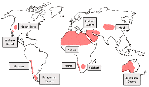
- hot deserts – like Saharan desert
- mid-latitude deserts – like Gobi desert.
Hot deserts – distribution
- Important hot deserts of the world are situated on the western edges of the continents between latitudes 15 to 30 degrees north and south.
- Sahara desert is the largest of hot deserts, covering an area of 3.5 million square miles. Other prominent hot deserts include the Great Australian Desert, Arabian desert, Kalahari desert, Thar desert etc.
- Hot deserts are also found in the Americas. In North America, they are known by the names of Mohave, Sonoran, Californian, and Mexican deserts. They extend between USA and Mexico. In South America, the Atacama desert, or the Peruvian desert is located.
Hot deserts – Temperature
- These deserts are some of the hottest places on earth and have high temperatures all around the year.
- They do not have a distinct cold weather season.
- The average summer temperatures are always above 30 degrees centigrade.
- The hottest temperature to be recorded was in Libya in 1922. The temperatures rose as high as 57 degrees centigrade.
- Cloudless skies, intense insolation, dry air, and a rapid rate of evaporation are the reasons for such high temperatures.
- However, coastal areas of these deserts have a relatively moderate climate due to the moderating influence of seas. The cooling effect of cold currents also reduces the mean temperatures experienced in this region.
- The interior regions experience extreme temperatures – hot summers and cold winters.
- The diurnal temperature range is very high. Intense solar radiation during the day coupled with dry air and cloudless skies cause the temperature to rise with the sun.
- However, as soon as the sun sets, the mercury drops below the mean temperature due to continuous loss of heat by radiation coupled with the absence of cloud cover that could retain the heat.
- The average diurnal range of temperatures is around 14 to 25 degrees centigrade.
- During winter nights, frost is a common occurrence
Hot deserts – Precipitation
- Average annual precipitation in these regions is not more than 25 cm.
- Since these deserts are located within the Sub-Tropical High-Pressure Belts, also known as the Horse Latitudes, where the air masses are descending, conditions are not favourable for the formation of clouds which can cause precipitation.
- The prevailing winds in these regions are the Trade Winds which blow off-shore and do not allow any moisture-laden winds to blow over these regions from the sea.
- Westerlies which are on-shore do not blow over the desert regions, reducing the chances of any precipitation.
- The winds that blow over the deserts come from colder regions and their relative humidity is lowered as they blow over the desert. This reduces the possibility of condensation of water vapour, and hence any precipitation.
- The relative humidity decreases from 60 percent in the coastal areas to less than 30 percent in the interiors. This increases the rate of evaporation and reduces any chance of precipitation, making these deserts regions of permanent drought.
- The cold currents which flow along the west coasts of the continents have a desiccating effect on these deserts. Any moisture-laden winds blowing from the sea get condensed over the cold currents into mist or fog, and only drier winds blow over the deserts.
- However, convectional rainfall occurs in these regions in the form of violent thunderstorms for shorter durations. These sudden downpours often have disastrous consequences in the form of landslides.
- Atacama desert is the driest region in the world with an annual precipitation of less than 2 cm.
Mid-Latitude deserts – distribution
- These desert are often situated on plateaux and are a part of continental interiors.
- They include Gobi desert, Turkestan desert, Patagonian desert etc.
- In India, Ladakh desert falls under this category.
Mid-latitude deserts – climate
- In many ways, the climatic conditions of these deserts are similar to those of the hot deserts.
- Since these deserts lie at far away locations from the coast or are blocked by high mountains surrounding them, they are cut off from the moisture-laden winds blowing from the seas.
- Average annual precipitation does not exceed 25 cm.
- However, depression may penetrate into these deserts occasionally in Asia, bringing light rainfall in winters. Convectional rainfall can happen during the summers.
- These regions have a very range of annual temperatures, greater than that of hot deserts. The reason behind such extreme temperatures is Continentality – a phenomenon associated with landmasses which are at great distances from the coast.
- Winters experience freezing temperatures and very strong cold winds blow over these regions. Ice thaws during the summers sometimes causing floods at many places.
Desert Vegetation
- All deserts have some form of vegetation such as grass, scrub, weeds, etc.
- Though they may not appear green all the time, they lie dormant waiting for the rains which are irregular.
- The most common type of vegetation that is found in both hot and mid-latitude deserts is the xerophytic or drought-resistant scrub.
- Important species of this type include the bulbous cacti, long-rooted wiry grasses, thorny bushes, and dwarf acacia.
- In a few regions where there is abundant groundwater, clusters of date palms can be found, especially in the hot deserts.
- Vegetation that survives in these regions is of a special variety, which is adapted to intense aridity.
- Soils are deficient in humus due to the absence of moisture which slows down the rate of decomposition of organic matter.
- The shrub vegetation found in these deserts have a well-developed system of long roots which grow in search of groundwater. They have few or no leaves, and their foliage is hairy, waxy, or needle-shaped in order to minimise the loss of water through transpiration.
- The seeds of these plants have special mechanisms to protect themselves when they lie dormant, in the form of thick, tough outer surfaces. As soon as they are moistened by the rain, they germinate.
Life in the deserts
- Despite their inhospitable conditions, different types of human settlements have come up in these deserts
- Primitive hunters and gatherers: They are primitive tribes who do not cultivate any crops, or domesticate any animals. They include the Bushmen of the Kalahari desert, Bindibu or the Aborigines of Australia.
- Nomadic herdsmen: They pursue a livestock economy, wandering through the deserts along with their herds in search of water and green pastures. They include Bedouins of Arabia, the Tuaregs of Sahara, the Mongols of Gobi desert.
- Settled cultivators: They have survived close to rivers such as the Nile in Egypt, Indus in Pakistan, Colorado in the USA, and Tigris-Euphrates in Iraq. They cultivate crops like wheat, barley, sugarcane, fruits and vegetables
- Mining settlers: Prominent among these include the gold mines in Australia, Diamond mines in Kalahari, Copper mines in Chile, Silver mines in Mexico, Oil in the Persian Gulf countries.
Steppe Climate
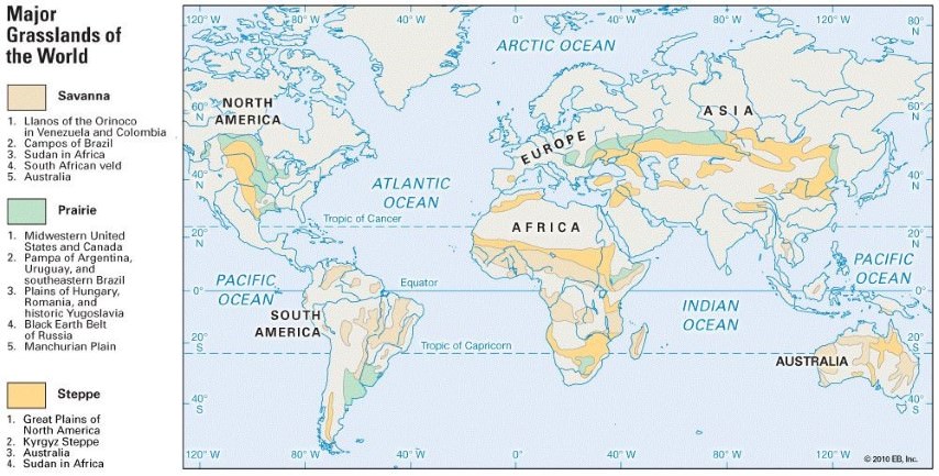
- The term steppe refers to a region which is a semi-desert with a grassland or shrub vegetation.
- Steppes are intermediate regions, not receiving enough rainfall to support a forest but are also not as dry as a desert.
- Steppe Climatic region is also known as Temperate Grasslands.
- These grasslands are some of the most developed agricultural fields and are termed as grain baskets.
- Livestock ranching is another major activity carried out in these areas due to the availability of natural grasses.
Distribution
- Steppes are found in the continental interiors.
- They are usually found in the temperate latitudes and hence come under the influence of Westerly winds.
- Steppes are characterized by vast grasslands which are, by and large, devoid of trees.
- Steppes typically refer to the vast temperate grasslands of Eurasia, which stretch between the Black Sea coast on the east to the Altai mountains in the west, covering a length of over 2000 miles.
- Steppes are known by their regional names in different parts of the world. They include,
- Prairies – North America
- Pustaz – Hungary
- Pampas – Argentina and Uruguay
- Velds (High Veld) – South Africa
- Downs – Australia
- Canterbury – New Zealand
Precipitation
- The average annual rainfall over the steppes varies from 25 to 75 cm, depending upon the region.
- The highest rainfall occurs in the spring season, or just prior to the onset of summers. In the northern hemisphere, it occurs in the months of June and July.
- During the winters, Westerlies bring in occasional depressions which often cause snowfall over these regions. However, the overall precipitation in the winters is low, at an average of 25 cm.
- In the southern hemisphere, due to a larger influence of maritime weather, higher rainfall occurs over these regions as compared to their counterparts in the northern hemisphere.
Temperature
- These regions are under the effect of continentality and hence experience extremities in temperature.
- Summers are warm with the average temperature in the range of 18-20 degrees centigrade.
- Winters are usually cold with occasional snowfall.
- The steppes in the northern hemisphere have a very high annual range of temperatures.
- To its contrast, the steppes in the southern hemisphere, due to maritime influence, have a moderate climate throughout the year.
Winds
- The prevailing winds of these regions are the Westerlies, which are responsible for precipitation during the winters.
- Apart from these, there are many local winds which blow over these regions and have a significant impact on the local weather.
- They are known by various names such as Mistral (France), which is cold dry wind; Loo (Gangetic plains), Sirocco (Sahara), Foehn (Alps) etc. are warm, dry winds.
- Chinook is a hot, dry local wind blowing over the North American Prairies. It is a Katabatic wind, descending from the Rocky mountains, and blowing from the south-west direction.
- Since it’s a hot wind, it raises the temperature in the region by over 5 degrees centigrade within a short time of 20 minutes.
- It is useful for the local agriculture because it melts the snow over the pastures, making it possible for the animals to graze on them.
Vegetation
- In contrast with the tropical grasslands of savanna, which are interspersed with trees, temperate grasslands are practically treeless. Also, the grass in these grasslands is much shorter as compared to that in savanna
- However, the grass is fresh and nutritious, unlike the coarse grass found in the savannas. This is mostly true for the prairies of North America, and also the Chernozem grasses of Ukraine. The prairie soils are also nutritious black earth soils.
- The grass is lean, thin and scattered.
- This makes them ideal for large-scale livestock rearing, also known as ranching.
- The grass growing season is throughout the year, uninterrupted by seasonal variations in temperature and precipitation
- Towards the poleward extension of prairies, there is a transitional zone of forests in which conifers can be found.
- Within the farmlands of steppes, trees are planted around the croplands to shield them from strong winds.
Economy
- Unlike the savannas which are home to some of the largest terrestrial animals, steppes do not have much animal diversity.
- In the Eurasian steppes, Horses can found riding in the open.
- Crop cultivation is extensively practised in these grasslands, especially in the prairies. This is because of the development of irrigation canals in the last century.
- Mechanized cultivation over large tracts of land is practised, making them one of the most productive agricultural regions in the world. Prairies are also known as the granaries of the world.
- Wheat and maize are the prominent crops of the prairies.
- Apart from the prairies, the Pampas of Argentina and the Downs of Australia are also known for extensive wheat cultivation.
- Steppes are mostly level grasslands which make ploughing and harvesting a relatively easy job, aided by machines
- Animal rearing or livestock ranching is carried out over thousands of hectares. The less nutritious tufted grass was replaced by, the more nutritious Lucerne or alfalfa grass. This aids in the rearing of cattle and sheep on a large-scale.
- Hence, they have emerged as the leading regions for animal ranching in the world.
- These grasslands are the largest producers of dairy and other animal products in the world. Milk, butter, cheese, beef, animal skins etc. are exported to far off regions aided by easy access to containerized cargo, and refrigerated ships
- Nomadic herding is practised in the vast steppes of Eurasia by the natives such as Kazakhs and Kirghiz who are wandering tribes. Long periods of drought because of unreliable rains in the continental interiors have made crop cultivation and settled animal rearing almost impossible in this region.
- In some regions where water is available, large-scale collective farming was introduced by Russia.
- Various grassland regions are famous for different kinds of economic activities. They include,
- Prairies – Wheat cultivation, livestock ranching.
- Velds – sheep and cattle rearing, maize cultivation
- Pustaz – wheat and beet sugar cultivation.
- Pampas – wheat cultivation, export of dairy, beef products.
- Downs and Canterbury – Wool production from Merino sheep, dairy products
Mediterranean Climate (Western Margin Climate)
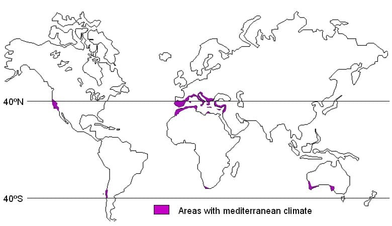
- The warm temperate western margin climate or the Mediterranean climate is found between 30o and 45o North and South of the Equator.
- This climate is witnessed in relatively fewer parts of the world and is almost entirely confined to the western margins of the continental landmasses.
- The basic cause of this climate is the seasonal shift of the wind belts.
Distribution
- Central Chile,
- California (around San Francisco),
- The southwestern tip of Africa (around Cape Town),
- Southern Australia (in southern Victoria and
- Around Adelaide bordering St, Vincent, and Spencer Gulfs), and south-west Australia (Swanland).
Climate
- The Mediterranean climate is characterized by very distinctive climatic features with dry, warm summers and wet, cold winters and local winds.
- Dry, warm summers with off-shore Tradewinds:
- During the summer months, the sun is overhead the Tropic of Cancer and Tropic of Capricorn.
- The belt of the influence of the Westerlies is shifted polewards, and the rain-bearing tradewinds are likely to be off-shore.
- Hence the regions are practically rainless in summers and hence remain dry.
- The heat is intense and the days are excessively warm.
- In the interiors, prolonged droughts are common. The relative humidity is generally low.
- The summer temperatures are relatively high, and the highest temperatures are experienced away from the coast in the continental interiors of the Balkan peninsula, the Anatolian plateau, and the Mediterranean Middle East.
- Wet, cold winters with on-shore Westerlies:
- In the winter months, the Westerlies belt shifts equatorward and the Mediterranean regions are under the influence of on-shore Westerlies.
- Hence, these lands receive almost all of their precipitation during the winter months.
- The rain comes in heavy downpours and causes floods in the months of September and October in Mediterranean Europe.
Local winds
- The Mediterranean climatic region in Europe experiences many local winds due to the topography of the region with the Alps in the North, the Sahara desert in the South, the continental interiors in the East, and the open Atlantic in the west. These create great differences in temperature, pressure, and precipitation. The two most important local winds are:
- Sirocco
- This is a hot, dry and dusty wind.
- It originates in the Sahara desert and might occur at any time of the year but is mostly witnessed during spring.
- Normally it lasts only for a few days.
- It blows from the desert interiors of Sahara into the Mediterranean Sea and is usually associated with the depressions from the Atlantic ocean.
- After crossing the Sea, it is slightly cooled by the absorption of water vapour but is hot enough that it withers vegetation and crops of the region.
- Hence it is also called “Blood Rain” because it is carrying the red dust of the Sahara desert.
- Mistral
- Mistral is a cold wind from the north.
- It rushes down the Rhone valley and its velocity is intensified by the funnelling effect in the valley between the Alps and the Central Massif[Plateau in France].
- In some extreme cases, the velocity of the wind is so high that trains can be derailed and trees are uprooted.
- In winter, if the Mistral is frequent the temperatures could go below the freezing point.
- Other local winds
- Bora: Cold north-easterly wind along the Adriatic coast.
- Tramontana and Gregale: cold winds in the Mediterranean Sea.
Natural Vegetation
- The vegetation of the region is not luxuriant.
- Trees are with small broad leaves and are widely spaced.
- The absence of shade is a peculiar feature of this climate and the growth is almost restricted to autumn and spring.
- Plants are in a continuous struggle against heat, dry air, excessive evaporation and prolonged droughts.
- Hence they are generally xerophytic or drought resistant in nature.
- Types of Mediterranean vegetation:
- Evergreen forests
- They are found only in climatically suitable regions with rainfall over 25inches and are open woodlands with evergreen oaks.
- The cork oaks are used for making wine-bottle corks.
- In Australia, the eucalyptus forests replace the evergreen oak.
- The giant sequoia or redwood is typical of the Californian trees.
- Evergreen Coniferous forests
- They include various kinds of pines, firs, cedars and cypresses.
- They appear mostly in the cooler highlands and where droughts are not so severe.
- Bushes and Shrubs
- This is the most prominent type of Mediterranean vegetation.
- The low bushes grow in scattered clumps and are often thorny.
- Grass
- Since most of the rain comes during the cool season when the growth is slow, the conditions of this region do not suit grass.
- They are generally wiry and bunchy and are not suitable for animal farming.
- Thus cattle rearing is not an important occupation in the Mediterranean.
- Evergreen forests
Economic Development
- The region is important for fruit cultivation, cereal growing, wine-making and agricultural industries as well as engineering and mining. The region is a net exporter of citrus fruits and the net importer of dairy products.
- Orchard farming
- These regions are known as the world’s orchard lands.
- A wide range of citrus fruits grows in the region. Examples: Sunkist oranges of California, Jaffa oranges of Israel.
- The fruit trees have long roots to draw water from depths during the long summer months.
- The olive tree is probably the most typical of all Mediterranean cultivated vegetation.
- Besides these, many nut trees like chestnuts, walnuts, hazelnuts and almonds are grown.
- Other important fruits are peaches, apricots, pears, cherries, plums and figs.
- Crop cultivation
- Cereals are the most important crops and wheat is the leading crop followed by barley.
- Though the climatic conditions are not favourable for the extensive cultivation of wheat, the farmers have utilised the seasonal climatic rhythm to their best advantage.
- Sheep rearing
- The mountain pastures with cooler climate support a few sheep, goats and cattle.
- Transhumance is widely practised in the region.
- Wine production
- Viticulture is speciality and tradition of Mediterranean region.
- The long, sunny summer allows the grapes to ripen.
- Regions bordering the Mediterranean Sea account for three-quarters of the world s production of wine.
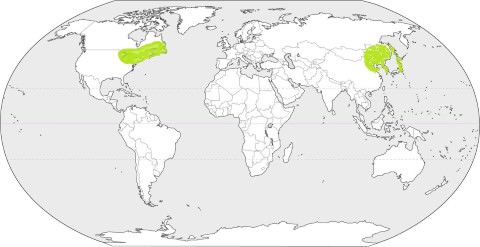
Warm Temperate Eastern Margin Climate
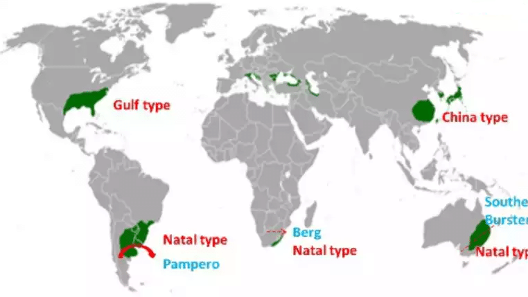
- It is found along the eastern margins of the continents between 20 and 35 N and S latitude.
- The climatic features in the region are similar to the monsoonal climate with rain during the summer and dry weather during winter.
Variations of warm temperate eastern margin climate
- China Type: Temperate monsoon or China type found in most parts of China and is a modified form of monsoonal climate.
- Gulf Type: Though less pronounced, the overall climate resembles the China Type. It is found in the south-eastern parts of the USA bordering the Gulf of Mexico. The continental heating during summers induces an inflow of air from the cooler Atlantic Ocean.
- Natal Type: In Southern Hemisphere, this climate is witnessed in New South Wales, Natal and Parana-Paraguay-Uruguay basin. This is often referred to as Natal Type of climate and is influenced by the on-shore Tradewinds all round the year.
Climate
- It is typified by a warm moist summer and a cool, dry winter.
- Occasionally, the penetration of cold air from the continental interiors may bring down the temperature to the freezing point.
- The relative humidity is little high in mid-summer but for most of the time, the climate is pleasantly warm.
- Rainfall is more than moderate and ranges between 60 cm to 150 cm and there is a uniform distribution of temperature throughout the year.
- Rain comes either from convectional sources or as orographic rain in summer, or from depressions in prolonged showers in winter.
- Local storms also occur. Example: typhoons, hurricanes.
- The rainfall is adequate for all agricultural purposes and hence the areas are densely populated.
- China Type:
- It is the most typical of the warm temperate eastern margin climate.
- In summer due to intense heating of the continental interiors of the heart of Asia including Tibet, a low-pressure system is set in which attracts the tropical Pacific air stream.
- This is witnessed as the South-East monsoon in the region.
- In winter, there is an intense high pressure over Siberia and the continental polar air stream flows outwards as the North-West Monsoon, bitterly cold and very dry.
- There is little rain but there is considerable snow.
- The region also experiences intense tropical cyclones called typhoons that originate in the Pacific Ocean and are most frequent in the late summer.
- The Gulf Type:
- The Gulf-Atlantic regions of the USA experience this type of climate similar to the China type but with less the monsoonal characteristics.
- The warm Gulf stream and the on-shore Tradewinds help bring down the range of temperatures and there is heavy annual rainfall of around 59 inches.
- The amount of rain is increased by thunderstorms in summer and by hurricanes in September and October.
- Due to intense local heating, the region also experiences violent tornadoes leading to heavy destruction.
- Natal Type:
- The narrowness of the continents and the dominance of maritime influence eliminate the monsoonal elements.
- The South-East Tradewinds bring about a more even distribution of rainfall throughout the year.
- The annual range of temperature is low and rain comes in prolonged showers
Natural Vegetation
- Due to heavier rainfall, the region supports luxurious vegetation.
- There is perennial plant growth and the conditions are well suited to a rich variety of plant life.
- The lowlands carry both evergreen broad-leaved forests and deciduous trees, similar to the tropical monsoon forests.
- In the highlands, are various species of conifers such as pines and cypresses which are important softwoods.
- Eastern Australia – Eucalyptus
- South-Eastern Brazil, eastern Paraguay, north-eastern Argentina – Parana pine, the quebracho, wild yerba mate trees.
- Natal: palm trees
Economic Development
- These regions are the most productive part of the middle latitudes since there is adequate rainfall, no prolonged drought and the cold season is warm.
- This shows that the growing season is almost continuous.
- The temperate monsoon regions are the most intensively tilled parts of the world.
Farming in Monsoon China
- Monsoon China along with southern Japan and other parts of the eastern margin climate regions accounts for almost a third of the world population.
- It is the world’s greatest rice-growing regions and a third of the world’s rice is grown in China.
- Monsoon China has ideal conditions for paddy cultivation: a warm climate, moderately wet throughout the year, and extensive lowlands with moisture-retentive alluvial soils.
- The Chinese practice ‘wet-paddy’ cultivation and calls for endless hard labour. Thus the region calls for a huge population.
- Farming is usually on a subsistence basis. But progress has been made towards double and treble cropping which has increased the total rice production.
- Sericulture has also been practised in the region but is now on a decline.
Agriculture in the Gulf States
- Agriculture in the Gulf States of the USA differs from that of the Monsoon China. Rice is relatively less important and the focus is more on corn, cotton, and tobacco.
- Corn:
- The humid air, the sunny summer and the heavy showers suit the crop well.
- The region accounts for more than half of the world’s corn production but exports very less.
- Corn is used for fattening animals mostly cattle and pigs.
- It gives twice as much food mainly starch per acre when compared to wheat and other cereals.
- Cotton:
- It is the most prominent cash crop grown in the region.
- The climate is very suitable for the cotton growing with its long, hot growing season with nearly 200 days being frost free and moderately high temperatures.
- Fine quality cotton also comes from well irrigated dry areas.
- The fibre is most vital to the economic well-being of the southerners in the USA.
- It shapes their trade, prosperity and politics.
- The most dreaded enemy of the Cotton Belt is the boll-weevil. The pest multiplies rapidly. The pest is responsible for the westward migration of the Cotton Belt.
- Tobacco:
- It is another important crop of the region and incidentally is also the native crop of America.
- The humid atmosphere, the warmth and well-drained soils enable the successful growth of tobacco in the Gulf States.
- Around half of the tobacco in the international trade comes from this region.
- Corn:
Crop cultivation in the eastern margins of the Southern Hemisphere
- In the coastlands of Natal, cane sugar is the dominant crop
- It is followed by cotton and tobacco in the interiors.
- Maize is also extensively cultivated for use as food and feed for cattle rearing.
- The extensive natural pastures provide valuable forage for both cattle and sheep.
- In South America rainfall is less, cattle and sheep are reared for meat, wool and hides.
- Mild winters favour animal rearing, as they can be kept out of doors for a long time.
- In Australia, the moist Tradewinds bring heavy rainfall to the coastal districts and these are thickly wooded.
- Giant eucalyptus trees are grown in the region.
- The region is chief source of Australia’s milk, butter, cheese besides cotton, cane sugar and maize.
British Type Climate
- British-type climatic regions are under the permanent influence of the Westerlies all round the year.
- These are also regions of high cyclonic activity., typical of Britain and thus said to experience the British climate.
- This climate is also referred to as the cool temperate western margin climate or the North-west European Maritime Climate.
Distribution
- Northern Hemisphere
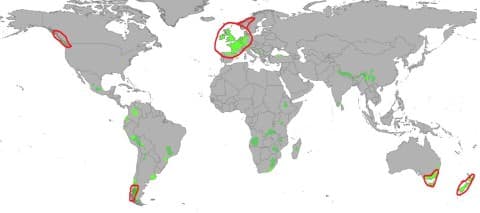
- The climatic belt stretches from Britain into North-West Europe, including northern and western France, Belgium, the Netherlands, Denmark, western Norway and also north-western Iberia.
- In North America, it confines mainly to the coastlands of British Columbia. The Rockies in North America, prevent the on-shore Westerlies from penetrating far inland.
- Southern Hemisphere
- The climate is experienced in southern Chile, Southern Australia, Tasmania and most parts of New Zealand, particularly in South Island.
- The surrounding large expanses of water in these regions have increased the maritime nature of the climate.
Climate
- Characteristics
- Moderately warm summers and fairly mild winters. Extremes of temperatures are not likely.
- Adequate rainfall throughout the year.
- Temperature
- The mean annual temperature is usually in the range of 5 C – 15 C.
- This range is comparatively small for such high latitudes.
- Summers are never very warm and winters are abnormally mild with no station recording below freezing point temperatures.
- This is due to the warming effect of the North Atlantic Drift and prevalence of the South-Westerlies.
- Hence, they are some of the most advanced regions of the world.
- Precipitation
- Adequate rainfall throughout the year.
- There’s tendency towards a slight winter or autumn maximum from cyclonic sources.
- The rain-bearing winds come from the west and hence the western margins have the heaviest rainfall.
- The amount of rainfall decreases as one moves away from the sea, eastwards.
- Seasons
- There are four distinct seasons.
- Summers are long and sunny followed by autumn which is a roar of gusty winds.
- Winter is the season with cloudy skies, foggy and misty mornings and many rainy days from the passing depressions.
- This is followed by spring which is the driest and most refreshing season from the depressing winter and the cycle repeats itself.
Natural Vegetation
- The natural vegetation of this climatic type is the deciduous forest.
- The trees shed their leaves in the cold season. This is an adaptation for protecting themselves against the winter snow and frost.
- Shedding begins in autumn, the fall season and is scattered by the winds.
- Some of the common species of temperate hardwood include oak, elm, ash, birch, beech, hornbeam, and poplar.
- In the wetter areas grow willows, alder and aspen.
- The deciduous trees occur in pure stands and have great lumbering value from the commercial point of view.
- The sparse undergrowth is useful in logging operations.
- The deciduous hardwoods are excellent for both fuel and industrial purposes.
- Higher up the mountains in the Scandinavian highlands, the Rockies, the southern Andes and the Southern Alps of New Zealand, the deciduous trees are generally replaced by the conifers which can survive a higher altitude, a lower temperature and poorer soils.
Economic Development
- In Britain, only 4% of the original forest is left. A very large part of the deciduous hardwoods has been cleared for fuel, timber or agriculture.
- Lumbering in quite profitable in the region for the reasons mentioned above.
Agriculture
- Due to the high density of population, all the cereals, fruits, and root crops grown in the region are used for home consumption and the region is a net importer of food crops.
- Market Gardening:
- Nowhere else is market gardening practised as extensively as in North West Europe.
- The factors that account for this are large urban population and high densities, highly industrialised nations like Britain, France, Germany.
- There is great demand for fresh vegetables, green salads, eggs, meat, milk and fruits.
- Farming is carried out intensively and the yield is high due to soil fertility and there are maximum cash returns.
- Since the crops are perishable, there is a good transport network and the vegetables and fruits are conveyed at high speeds to urban centres.
- Hence the term “truck farming” is often used to describe this kind of agriculture.
- In Australia, high-speed boats ply across the Bass Strait daily from Tasmania to rush vegetables, tomatoes, apples and beans to most of the large cities in mainland Australia.
- It is no wonder the Australians nicknamed Tasmania the garden state .
- Mixed Farming:
- Throughout north-western Europe, farmers practice both arable farming (cultivation of crops on ploughed land) and pastoral farming (keeping animals on grass meadows).
- The proportion of crops and animals in the farm at any time depends to a great extent on the type of soil, the price of the cereals and the demand for animals and animal products.
- Amongst the cereals, wheat is the most extensively grown, almost entirely for home consumption. The region is a net importer of wheat.
- The next most important cereal is barley.
- It is used in beer-making or whisky distilling and is raised in drier areas.
- The most important animals kept in the mixed farm are cattle.
- The climate of this region is ideal for intensive dairying.
- New Zealand ranks as one of the world’s greatest exporters of dairy products.
- Besides dairying, some cattle are kept as beef cattle.
- In Argentina or Australia, meat production is the primary concern.
- Sheep rearing:
- Sheep are kept both for wool and mutton.
- Britain is the home for some of the best-known sheep breeds.
- The principal sheep areas are in foothills, well-drained uplands, chalk and limestone scrap lands and the light and sandy coasts.
- Sheep rearing is the chief occupation of New Zealand, with its greatest concentration in the Canterbury Plain.
- It accounts for only 4 percent of the world’s sheep population but accounts for two-thirds of the world’s mutton exports and one-sixth of world wool exports.
Industrialization
- The countries are concerned in the production of machinery, chemicals and textiles.
- Industries are also based on dairy products in Denmark, Netherlands and New Zealand.
- The region is highly industrialised and differs from many others in its unprecedented industrial advancement.
- Britain, France and Germany have significant mineral resources and are heavily industrialized.
- Ruhr region in Germany, Yorkshire, Manchester and Liverpool regions in Britain are significant for wide-ranging manufacturing industries in the region.
Taiga Climate (Coniferous Forests & Lumbering)
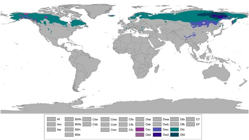
- Taiga Climate is also known as Cool Temperate Continental Climate and is popular by various other names such as Siberian Climate, Boreal Climate.
- This type of Climate is mainly found in the Northern Hemisphere and is absent in the Southern Hemisphere due to narrow land surface in Southern Hemisphere.
- Koppen has defined Taiga Climatic region as D type in his climatic classification.
- According to Koppen’s classification, the summer months are warm with temperature more than 10 degrees C while the winter temperature can be less than 3 degrees C.
Distribution:
- It stretches from 50 N to 70 N along a continuous belt across central Canada, some parts of Scandinavian Europe and most of central and southern Russian.
- On the north or polewards it merges into the Arctic tundra of Canada and Eurasia at around the Arctic circle. Hence this climate is also called “Sub-arctic climate”.
- On the south, the climate becomes less severe and merges into the temperate Steppe climate.
- In the Southern Hemisphere, the Siberian climate is absent due to the narrowness of the continents in the high latitudes.
- The strong oceanic influence in the Southern Hemisphere also reduces the severity of the winter.
Climate
In Taiga climatic region the summer may be warm or cool while the winter is bitterly cold due to the strong wind and snowstorms which flow from the continental polar and Arctic air mass.
Temperature
- The climate of these regions is characterized by extremely cold winters of long duration, with temperatures ranging around – 30 C to – 40 C.
- The summers are cool and brief. Spring and autumn are very brief and transitional periods.
- Annual range of temperature is very high, almost 50 C to 60 C.
- The coolest place on earth, Verkhoyansk is situated in this climatic region.
- With extremely low temperatures for the most part of the year, heavy snowfall and frosts are common in this region.
- Lakes and rivers are frozen and northerly polar winds such as Blizzards of Canada and Buran of Eurasia blow violently.
- Conditions are so extreme that Siberian climatic regions are very sparsely populated.
Precipitation
- Maritime influences are nearly absent in the interiors and hence the annual precipitation is low, generally around 38cm to 63 cm.
- It is well distributed throughout the year, with a summer maximum from convectional rain when the continental interiors are heated.
- In winter, the precipitation is in the form of snow.
Natural Vegetation
- The predominant vegetation of this region is evergreen coniferous forests.
- Conifers are very well adapted to this region to withstand such inhospitable climate.
- The greatest single band of the coniferous forest is the taiga in Siberia.
- Four major species of coniferous forests grow in the region: pine, fir, spruce, and larch.
- The coniferous forest belts of Eurasia and North America are the richest sources of softwood.
Coniferous forests are of huge commercial value due to the following reasons:
- They occur in pure stands and there exist only a few species.
- Unlike the equatorial rain forests which are of high density and difficult to exploit, the coniferous forests occur in uniform heights, grow straight and tall and are of moderate density.
- Almost all conifers are evergreen. There is no annual replacement of new leaves as in deciduous trees.
- The low annual temperatures with more than half the year below the growing-point temperature is a huge advantage for the evergreens.
- Conifers are conical in shape and with this adaptation, they survive in the sub-arctic climate.
- The sloping branches prevent snow accumulation and offer little grip to the winds.
- Leaves are small, thick, leathery and needle-shaped to check excessive transpiration.
- The undergrowth in the region due to poor podzolized soils which are excessively leached and acidic.
- Since the leaves of the evergreen forests do not fall, they offer little humus formation and the rate of decomposition of the leathery needles is slow due to low temperatures.
- Also, the absence of direct sunlight and short duration of summer are other deterrents for sparse undergrowth.
- Besides the continental interiors of high latitudes, coniferous forests are also found in regions of high altitude and reduced temperatures. Example: In the Himalayas.
Economic Development
- The coniferous forests regions in the northern hemisphere are little developed.
- Most of these forests are still untouched as they are not accessible.
- In the more accessible areas of the forests, lumbering is the predominant occupation.
- Few crops survive in the Siberian climates with long, cold winter and frozen winters.
- Hence there is little agriculture in these lands.
- Many of the natives like Samoyeds, Yakuts or Siberia and some Canadians are engaged in hunting, trapping and fishing.
Two major activities of the region are trapping and lumbering.
Trapping
- Many fur-bearing animals inhabit the northern lands of Canada and Eurasia.
- In Canada, trappers and hunters armed with modern automatic rifles in the midst of coniferous forests track down these animals.
- Muskat, ermine, mink and silver fox are the most important fur-bearing animals.
- Many fur farms have been established in Canada, to ensure regular supply of furs.
- In Siberia, other fur-bearing animals like the squirrels, otters, bears, sables, lynxes, martens and foxes are trapped.
Lumbering
- This is the most important occupation of the Taiga type of climate.
- Trees are felled for many purposes such as saw-milling, paper and pulp industry, fuel, industrial raw material.
- Saw-milling: This processes logs into sawn-timber, plywood, planks, hardboard and other constructional woods.
- Paper and pulp industry: By mechanical and chemical means, timber is pulped to make wood pulp. This is used as a raw material for papermaking and newsprint.
- Fuel: Softwoods are not used as fuel due to its industrial uses. Hardwoods are burnt as fuel, particularly in the tropical regions. Since this region is covered with softwoods, less than a quarter of it is used as fuel.
- Industrial raw material: Timber has a wide range of industrial uses. Timber is used for making furniture, matches, wood-carvings, toys, crates and packing cases.
Factors favorable for Lumbering in Siberian Climate:
- Coniferous forests occur in pure stands or homogenous groups and not mixed as the tropical forests.
- This not enhances the commercial value of the felled timber, but also save time and money.
- Lumbering replaces agriculture as in these high latitudes agriculture is highly unproductive.
- In winter the sap of the trees ceases to flow and lumbering is normally carried out in the winter months.
- The snow-covered ground in winters makes logging and haulage relatively simpler.
- The logs and dragged and float on the rivers to the sawmills downstream. This has greatly helped the lumbering industry in Canada and Sweden. But in Siberia unfortunately, all the rivers drain polewards into the Arctic Ocean.
- Cheap hydro-electricity for driving sawmills is harnessed from the mountainous uplands of North America and Europe which have greatly assisted the lumbering industry.
Laurentian Climate
- The Cool Temperate Eastern Margin climate is also known as the Laurentian climate.
- It is the intermediate between the British and Siberian types of climates.
Distribution
- It is found only in two regions and only in the northern hemisphere.
- The climate has features of both the continental and the maritime climates.
- North American region: One region is north-eastern North America including eastern Canada, north-east USA, and Newfoundland.
- Asiatic region: The other region is the eastern coastlands of Asia, including North China, eastern Siberia, Manchuria, Korea and northern Japan.
- The climate is totally absent in the southern hemisphere because only a small section of continental landmass extends south of the latitude of 40 S.
- The only possible regions are in eastern Patagonia.
- But the Southern Andes blocks the Westerlies and the region is subjected to aridity rather than continentality.
- It is a rain-shadow region and its annual precipitation is not more than 10 inches.
Climate
Temperature
- The climate of this type has cold, dry winters and warm, wet summers.
- Snow falls to quite a depth and winter temperatures may be well below the freezing point.
- Summers are as warm as the tropics and are moderated by the cooling effects of the off-shore cold currents from the Arctic.
Precipitation
- Rain falls throughout the year.
- But there is a distinct summer maximum because the easterly winds from the oceans bring rainfall.
- Two-thirds of the annual precipitation is in summer.
- Winters are dry and cold and westerlies blow out from the continental interiors.
The North American region
- The most remarkable characteristic of this region is the uniformity in annual precipitation.
- This is due to the Atlantic influence and that of the Great Lakes.
- The warm Gulf Stream increases the moisture content of easterly winds from the open Atlantic.
- The prevailing Westerlies carry depressions over the Great Lakes towards eastern regions causing wet conditions, especially in winter.
- Convergence of the warm Gulf Stream and the cold Labrador Current near Newfoundland produces dense mist and fog and gives rise to much precipitation.
- It is said that Newfoundland experiences more drizzles than any other part of the world.
- In summer the Westerlies bring fewer depressions and extend their continental influence to the coast.
- Temperatures are high in summer for that latitude and prolonged heat waves cause discomfort in crowded cities.
The Asiatic region
- In contrast to the North American region, the distribution of precipitation is less uniform in the Asiatic region.
- Winters are very cold and dry while summers are warm and exceptionally wet.
- The rainfall regime resembles the tropical monsoon type in India where the rainfall is concentrated in the three summer months.
The climate in Japan
- The climate of Japan is modified by its insularity and also by the meeting of warm (Kuroshio)and cold (Oyashio) ocean currents.
- It receives adequate rainfall from both the South-East Monsoon in summer and the North-West monsoon in winter.
- The rainfall is more evenly distributed with two maxima: the Plum rain in June and the Typhoon Rain in September.
Natural Vegetation
- The predominant vegetation in this climate is cool temperate forests.
- The heavy rainfall, the warm summers and the damp air from fogs all favour the growth of trees.
- Forest tend to be coniferous north of the 50 N latitude.
- South of this latitude, deciduous forests is seen.
Economic Development
- Lumbering and its associated timber, paper and pulp industries are the most important economic activities in the region.
- Lumbering has always been a major occupation in the sparsely populated Asiatic region and timber is the chief export item.
- The occurrence of trees in almost pure stands and the predominance of only a handful of species greatly enhance the commercial value of the forests.
Agriculture
- Agriculture is less important due to long and severe winters.
- The maritime influence and the heavy rainfall enable the growth of some hardy crops.
- In the North American region, arable farming is not carried out on a large scale and farmers are mostly engaged in dairy farming and fruit growing.
Fishing
Fishing is another outstanding economic activity of the Laurentian climatic regions.
- Off Newfoundland
- This is one of the world’s largest fishing grounds, particularly on the Grand Banks.
- The mixing of the warm Gulf Stream and the cold Labrador currents enable the growth of plankton and microorganisms.
- Fish feed on minute marine organisms called plankton present abundantly in the continental shelves and in shallow waters adjacent to the landmasses.
- Fish of all types and sizes breed her and support a thriving industry of not only Canada and USA, but also Norway, France, Britain, Portugal, Denmark, Russia and Japan.
- Both pelagic fish(which live near the surface) and the demersal fish (which live near the bottom) of shallow seas are caught.
- Over-fishing is a growing problem and strict measures in fish conservation are being taken.
- Off Japan
- Another major fishing area of the world in the North-West Pacific surrounding the islands of Japan.
- The mountainous nature of Japan and parts of mainland eastern Asia have drive people towards fishing.
- Hakodate and Kushiro are the major fishing ports and fish are either canned or preserved for export to neighbouring countries.
- The fish waste, fish meal and seaweeds are used as fertilizers in the farms.
- Coastal farms submerged in water grow seaweeds for sale as fertilizers, chemical ingredient and even as food.
- Another important aspect of fishing the pearl culture.
- Pearl oysters are brought to the surface and the highly prized pearls are extracted for sale as ornaments.
- Japan’s fishing is not limited to its territorial waters but they venture far and wide into the Arctic, Antarctic and the Atlantic waters.
- Fishing is a dominant occupation in Japan for the following reasons:
- Japan is not well endowed with natural resources and as much as 80 per cent of its land is non-agricultural. Hence people have taken up fishing for their livelihood and it has become their traditional occupation.
- Lack of lowlands and pastures means that only a few animals can be kept to supply meat and other protein food. Fish meat is the primary source of protein in Japan.
- The continental shelves around the Japanese islands are rich in plankton due to the meeting of warm Kurushio and cold Oyashio currents. These form excellent breeding grounds for fish.
- The indented coastline of Japan provides sheltered fishing ports, calm waters and safe landing places.
- With the progress of industries, fishing has become more scientific, aiming at heavy hauls, high returns and economy of time, effort and money.
- Most of the deep-sea fishing is now highly mechanised. Powered trawlers and modern refrigeration plants have increased the annual fish yield.
Polar Climate (Tundra & Ice Caps)
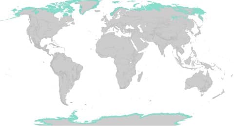
- Polar climate has cold climatic conditions all through the year.
- Koppen classified Polar Climate as E type in his climatic classification.
- According to Koppen the summer temperature in this region is less than 10 degrees. He further divided the polar climate as Polar Tundra and Polar Ice Caps.
Distribution
Northern Hemisphere
- The polar type of climate is primarily found north of the Arctic Circle in the northern hemisphere.
- The ice-caps are confined to Greenland and to the highlands of the high-latitude regions where the ground is permanently snow-covered.
- The lowlands which are ice-free for a few months have tundra vegetation.
- This includes the coastal strip of Greenland, the barren grounds of northern Canada and Alaska and the Arctic seaboard of Eurasia.
Southern Hemisphere
- In the southern hemisphere, the uninhabited land of Antarctica is the greatest single stretch of ice-cap where the layers of permanent ice are seen.
Climate
Temperature
- A very low mean annual temperature characterizes the tundra or polar temperature.
- Only four months have a temperature above freezing point. The ground remains frozen for all but four months.
- Interiors are much colder than the coastal regions.
- Winters are long and very severe, summers are cool and brief.
- Beyond the Arctic and the Antarctic circles, there are weeks of continuous darkness.
- Frosts and blizzards that occur are very hazardous to the polar inhabitants.
Precipitation
- Precipitation is mainly in the form of snow, falling in winter and being drifted by the blizzards.
- Convectional rainfall is generally absent because of the low rate of evaporation and the lack of moisture in the cold polar air.
- In summer, there is a maximum and the precipitation is in the form of rain or sleet.
- Cyclones are felt in the coastal areas and there is a tendency towards a winter maximum.
Natural vegetation
- In severe environments like that of Tundra, few plants survive.
- The greatest inhibiting factor is the lack of heat and energy.
- The growing season is for less than three months and there are no trees in the tundra.
- Hence only lowest forms of vegetation are supported like mosses, lichens, and sedges.
- In the more sheltered spots, stunted birches, dwarf willows, and undersized alders struggle to survive.
- In the brief summers when snow melts and the days are warmer and longer, berry bushes and Arctic flowers bloom.
- They are short-lived but they brighten the monotonous polar landscape into Arctic prairies.
Human Activites
- Human activities in the polar regions are largely confined to the coast.
- The high altitude plateaus and mountains are uninhabitable as these are permanently snow-covered.
- The people lead a semi-nomadic life.
- Eskimos live in Greenland, northern Canada, and Alaska.
- Earlier they lived as hunters, fishers, and food-gatherers but in recent years they have started settling in permanent huts.
- During winter, they live in compact igloos and in summer they pitch portable tents of skins by the side of streams.
- Their food is derived from fish, seals, walruses and polar bears.
- In Eurasian tundra, other nomadic tribes like Lapps of northern Finland and Scandinavia, the Samoyeds of Siberia(from the Ural Mountains and the Yenisey Basin), the Yakuts from the Lena basin, the Koryaks and Chuckchi of north-eastern Asia live.
- They wander with their herds of reindeer across the Eurasian tundra where there are pastures.
- In USSR, large farms have been established for raising reindeer and for breeding fur-bearing animals.
Importance and Recent Development of the Arctic Region
- The Arctic region was once regarded as completely useless to mankind.
- But now the economic importance of the region has been recognized.
- Because of the discovery of minerals, new settlements have come up in the region.
- New railway lines have been constructed to bring shipments of ores mined to the major industrial districts.
- Ports have been established in the Arctic seaboard of Eurasia. Hence it has become possible to ship timber and fur from Siberia.
Comments
Post a Comment