In this article I want to walk you through the Jet Stream UPSC (Climatology) for UPSC IAS Examination.
Jet streams are high-speed winds that occur in narrow bands of upper air westerlies. The width of this airband can be 160-480km wide and 900-2150m thick, with core speed exceeding 300km/hr. such is their strength that aircraft routes which run counter to jet movements are generally avoided. Jets are coincident with major breaks in the tropopause.
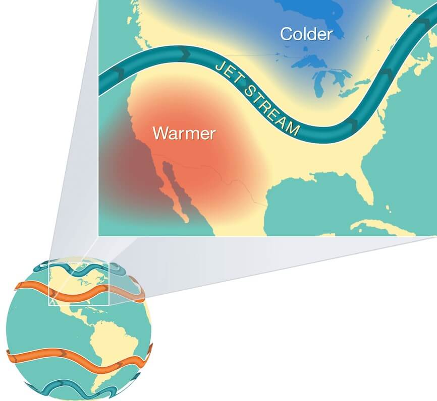
Jet Stream is a geostrophic wind blowing horizontally through the upper layers of the troposphere, generally from west to east.
Jet Streams develop where air masses of differing temperatures meet. So, usually surface temperatures determine where the Jet Stream will form.
Greater the difference in temperature, faster is the wind velocity inside the jet stream.
Jet Streams extend from 20 degrees latitude to the poles in both hemispheres.
What is Jet Stream?
i.e Jet streams are
- Circumpolar (situated around or inhabiting around one of the earth’s poles),
- narrow, concentrated bands of meandering, upper tropospheric, high velocity, geostrophic streams, bounded by low-speed winds, and are a part of upper-level westerlies.
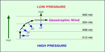
Geostrophic Wind
The geostrophic flow is the theoretical wind that would result from an exact balance between the Coriolis force and the pressure gradient force.
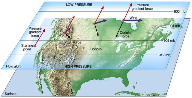
- The velocity and direction of the wind are the net results of the wind generating forces.
- The winds in the upper atmosphere, 2 – 3 km above the surface, are free from the frictional effect of the surface and are controlled by the pressure gradient and the Coriolis force.
- An air parcel initially at rest will move from high pressure to low pressure because of the Pressure Gradient Force (PGF).
- However, as that air parcel begins to move, it is deflected by the Coriolis force to the right in the northern hemisphere (to the left in the southern hemisphere).
- As the wind gains speed, the deflection increases until the Coriolis force equals the pressure gradient force (2 – 3 km above the ground, friction is low and winds travel at greater speeds).
- At this point, the wind will be blowing parallel to the isobars (perpendicular to Pressure Gradient Force). When this happens, the wind is referred to as geostrophic wind.
Why winds don’t flow from tropical high pressure (in upper troposphere) to polar low (in upper troposphere) directly as shown in the figure below?
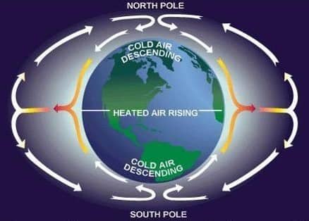
- Because these winds are geostrophic, i.e., they flow at great speeds due to low friction and are subjected to greater Coriolis force.
- So they deflect greatly giving rise to three distinct cells called Hadley cell, Ferrel Cell, and Polar cell.
- Instead of one big cell (as shown in fig) we have three small cells that combinedly produce the same effect.
Genesis of Jet Streams
The genesis of the Jet-streams is provided by three kinds of gradients:
- The thermal gradient between pole and equator
- The pressure gradient between pole and equator
- The pressure gradient between surface and subsurface air over the poles.
Characteristics of Jet Stream
- High velocity winds- 400-500km/hr. High velocity is due to great thermal contrast creating powerful pressure gradient force.
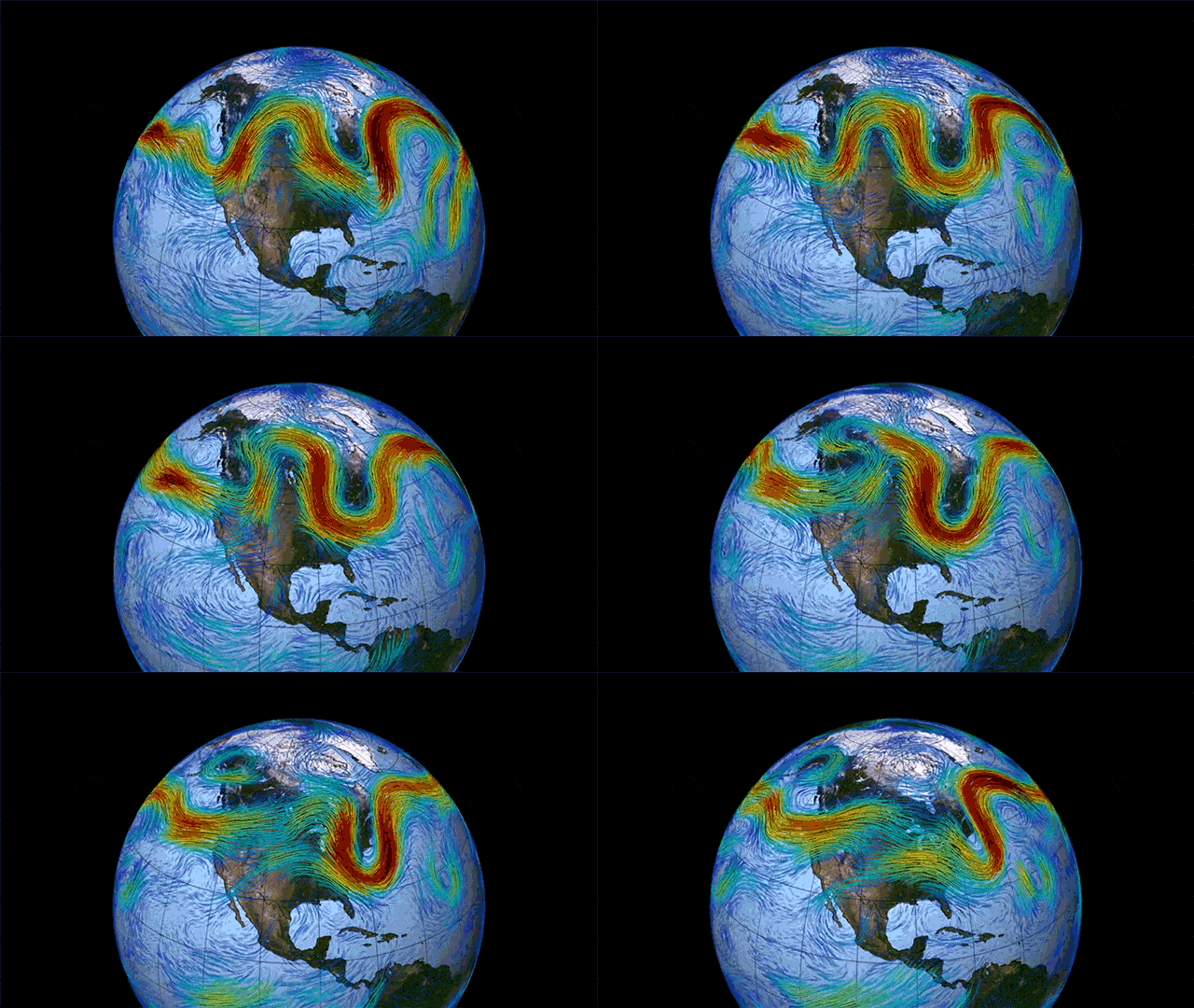
- meandering- jet streams encircle the globe, thus follow a curved path. Flow is 3 dimensional and develop
crests and trough - They cover hundreds of km in width and thousands of km in length.
- size and dimension- width-10-12km
depth-2-3 km
length-3000km
altitude – below the tropopause - they have seasonal variations and shift with the apparent movement of the sun
- Jet streams travel from west to east in both hemispheres
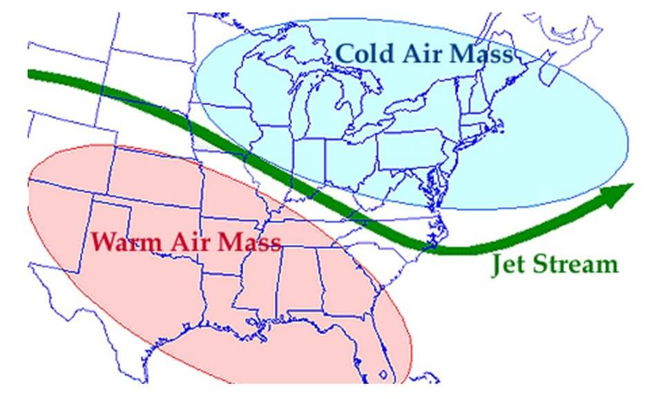
Types of jet Streams
- Polar front jet streams
- Subtropical Westerly Jet streams
- Tropical easterly Jet streams
- Polar night Jet Streams
- Local Jet Streams
Permanent jet streams – subtropical jets at lower latitudes and polar front jets at mid latitudes.
Temporary jet streams – Tropical Easterly Jet or African Easterly Jet ,and Somali Jet (southwesterly).
Polar Front Jet Streams
- Formed above the convergence zone ( 40-60 degree) of surface polar cold air mass and tropical warm air mass
- These move in easterly direction but are irregular
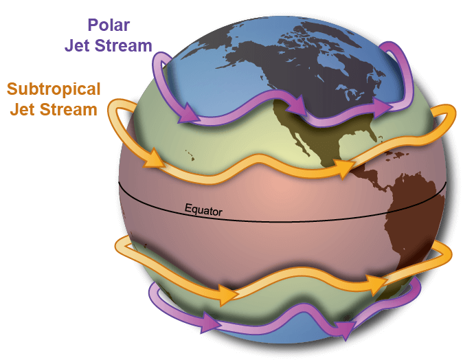
Subtropical Westerly jet Streams
- Formed above 30-35 latitude
- Move-in upper troposphere to the north of the subtropical surface high-pressure belt
- Also known as stratospheric subpolar jet streams
Tropical Easterly jet streams
Develop in upper troposphere above surface easterly trade winds over India and Africa during the summer season due to intense heating of Tibetan plateau and play an important role in Indian Monsoon
Polar Night Jet Streams
Develop in winter season due to steep temperature gradient in the stratosphere around the poles
Local Jet Streams
Formed locally due to local thermal and dynamic conditions and have limited local importance
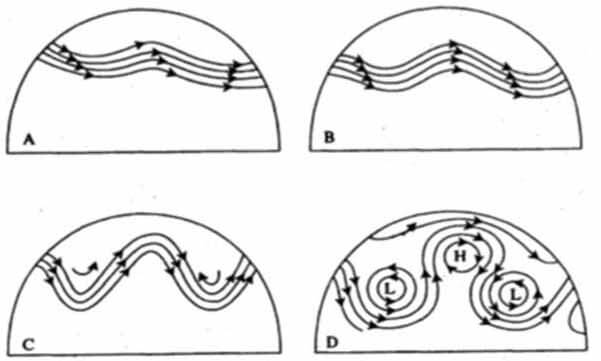
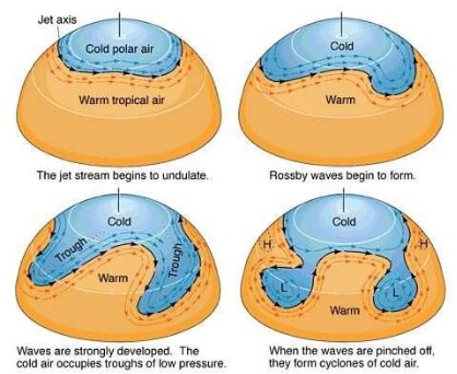
Index cycle of jet streams
Stage 1-
- In subpolar low-pressure belt, the cold air from poles and warm air from subtropics converge along a horizontal line
- Due to the great thermal contrast and differences in the physical properties, they don’t mix up.
- A zone of the stationery situation is created between these 2 air masses
Stage 2-
- Cold polar air is pushed by the easterlies and warm air is pushed by westerlies.
- The stationary situation is transformed into an oscillating wave. These are known as Rossby waves
Stage 3-
- Cold and warm air further invades each other territory and waves further meander.
- Jet streams of high sinuosity develop and attain maturity
- Stage 4 cold air mass moves into warm air and latitudinal heat exchange occurs.
- The stationary front situation is reattained.
Significance of jet streams
- The close relationship between the intensity of Mid-latitude cyclones and jet streams. The cyclones become very strong and stormy when the upper air tropospheric jet streams are positioned above temperate cyclones
- The monsoon of South Asia is largely affected and controlled by jet streams
Influencing factors on the Jet Stream Flow
- The factors that influence the flow of the jet stream are the landmasses and the Coriolis effect.
- Landmasses interrupt the flow of the jet stream through friction and temperature differences, whilst the spinning nature of the earth accentuates these changes.
- So the jet stream meanders across the earth, like a river meanders before it reaches the sea.
- The meandering sections of the jet stream continue to change as they interact with landmasses on again, creating an ever-changing state of flux and subsequent temperature differences.
- In winter the temperature of the stratosphere can also have an effect on the strength and position of the jet stream.
- The cooler the polar stratosphere, the stronger the polar/ tropical differential becomes; encouraging the jet stream to gain in strength.
- The warmth of the landmasses and oceans (such as the El Nino Southern Oscillation) can also have a bearing on the strength and amplitude of the jet stream.
Jet streams & the weather
- Jets streams play a key role in determining the weather because they usually separate colder air and warmer air.
- Jet streams generally push air masses around, moving weather systems to new areas and even causing them to stall if they have moved too far away.
- Climatologists say that changes in the jet streams are closely tied to global warming, especially the polar jet streams because there is a great deal of evidence that the North and South poles are warming faster than the remainder of the planet.
- When the jets streams are warmer, their ups and downs become more extreme, bringing different types of weather to areas that are not accustomed to climate variations. If the jet stream dips south, for example, it takes the colder air masses with it.
Air travel
- Jet streams play a major role in air travel.
- Eastbound flights usually take less flying time than westbound flights because of help from the fast-moving air.
- Jet streams can contain wind shear, a violent and sudden change in wind direction and speed, which is a major threat in air travel.
- Wind shear has caused airliners to suddenly lose altitude, putting them in danger of crashing.
- In 1988, the FAAdecided that all commercial aircraft must have wind-shear warning systems, but it wasn’t until 1996 that all airlines had them on-board.
Jet Streams affecting the Monsoons and the Indian Sub Continent
- There are different jet streams and in respect of the climate and monsoons of India, it is the Subtropical Jet Stream (STJ) and the countering easterly jet that is most important.
- As the summertime approaches there is increased solar heating of the Indian subcontinent, this has a tendency to form a cyclonic monsoon cell situated between the Indian Ocean and southern Asia.
- This cell is blocked by the STJ which tends to blow to the south of the Himalayas, as long as the STJ is in this position the development of summer monsoons is inhibited.
- During the summer months, the STJ deflects northwards and crosses over the Himalayan Range. The altitude of the mountains initially disrupts the jet but once it has cleared the summits it is able to reform over central Asia.
- With the STJ out of the way, the subcontinental monsoon cell develops very quickly indeed, often in a matter of a few days. Warmth and moisture are fed into the cell by a lower level tropical jet stream which brings with it air masses laden with moisture from the Indian ocean.
- As these air masses are forced upward by north India’s mountainous terrain the air is cooled and compressed, it easily reaches its saturation vapor point and the excess moisture is dissipated out in the form of monsoon rains.
- The end of the monsoon season is brought about when the atmosphere over the Tibetan Plateau begins to cool, this enables the STJ to transition back across the Himalayas.
- This leads to the formation of a cyclonic winter monsoon cell typified by sinking air masses over India and relatively moisture-free winds that blow seaward. This gives rise to relatively settled and dry weather over India during the winter months.

0 Comments