What is precipitation?
Precipitation is any form of liquid or solid water particles that fall from the atmosphere and reach the surface of the Earth.
Precipitation includes drizzle, rain, hail, snow and sleet.
Types of Precipitation
- Rain
- Drizzle
- Snow
- Sleet
- Hail
Rain
- Rain is precipitation that falls to the surface of the Earth as water droplets. Raindrops form around microscopic cloud condensation nuclei, such as a particle of dust or a molecule of pollution.
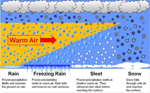
- Rain that falls from clouds but freezes before it reaches the ground is called sleet or ice pellets.
- Even though cartoon pictures of raindrops look like tears, real raindrops are actually spherical.
Drizzle
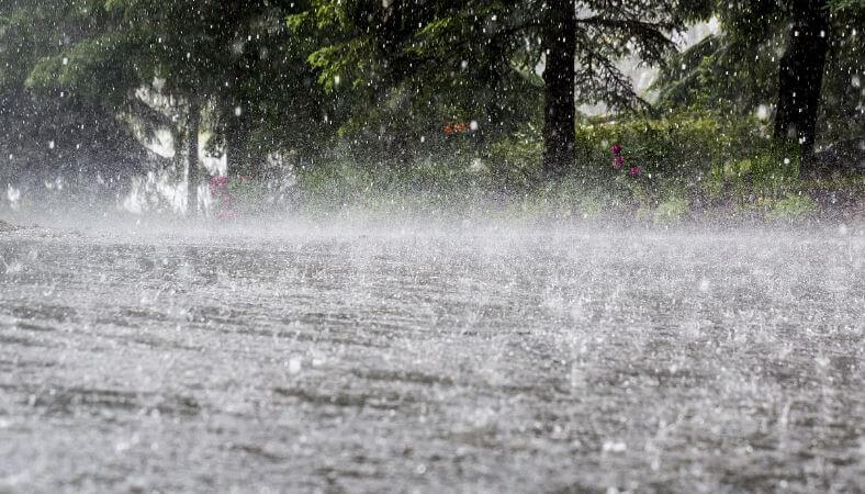
- Another variation from rain is drizzle. It consists of light water precipitation where liquid water droplets are smaller than those of rain. This can occur when updrafts in clouds are not strong enough to allow them to produce rain. Drizzle usually happens thanks to low-level clouds called ‘stratiform clouds.’
- Drizzle tends to occur more often over colder regions of the subtropics. In these locations, what scientists call a ‘supercooled drizzle’ or freezing drizzle, can also occur. This happens at temperatures as low as 10 degrees F or lower, depending on how shallow the cold air layer is.
- Drop size less than 0.5 mm.


Snow
- Snow consists of ice crystals in a flaky form, having an average density of 0.1g/cc. It is also an important form of precipitation that usually forms in colder climates and higher altitudes.

Sleet
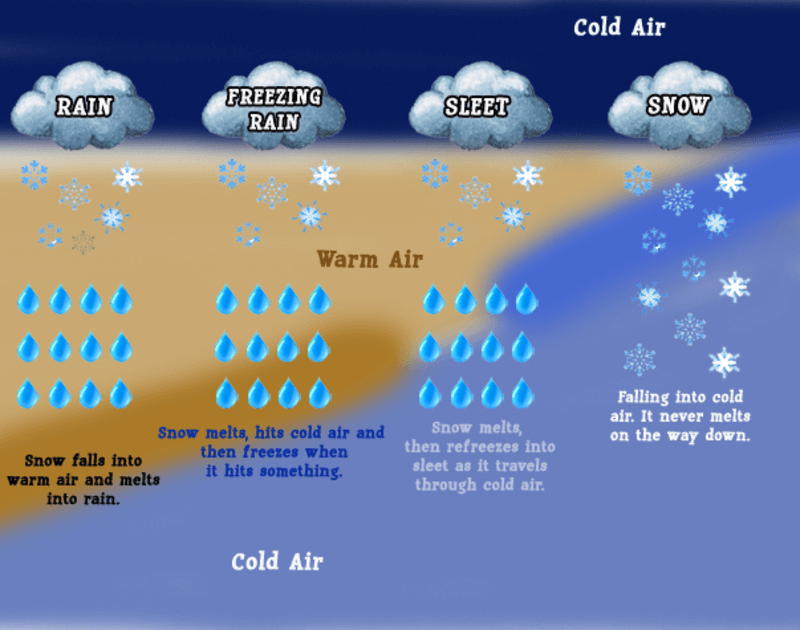
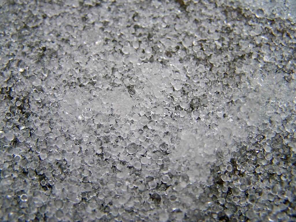
- Sleet is frozen raindrops that are formed when rainfall passes through the air in the atmosphere at subfreezing temperatures.
- It is a type of precipitation in the form of a mixture of rain and snow.
- It is a frozen rain which forms when rain while falling to the earth passes through a layer of the very cold air mass.
- Diameter > 5 mm
Hail
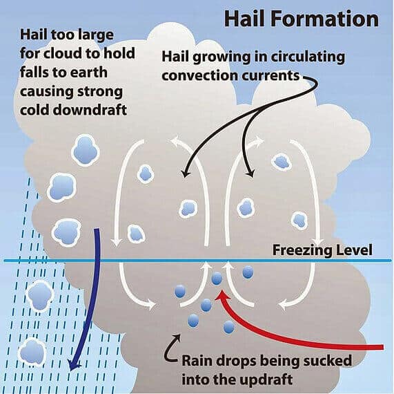
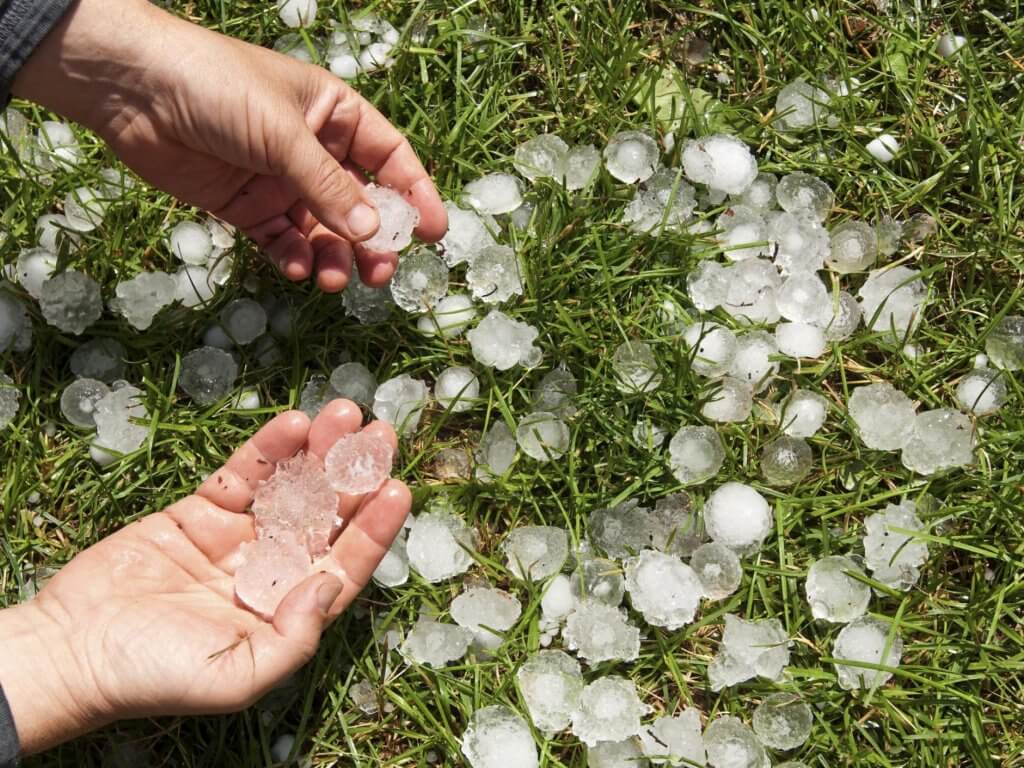
- Hail is a kind of showery precipitation in the form of pellets or lumps that have a size greater than 8mm. Hail occurs during violent thunderstorms.
- It falls in the form of small ice pellets. Hail is the most destructive form of precipitation produced in violent thunderstorms or cumulonimbus clouds.
- The hail consists of concentric layers of ice alternating with layers of snow. Its structure resembles that of onion.
Rainfall
Rainfall can be defined as the precipitation in the liquid form. There are various types of rainfall based on the origin
Types Of Rainfall
On the basis of mode of occurrence, the rainfall can be classified into three categories: – the convectional, orographic, or relief and the cyclonic or frontal.
Convectional rainfall
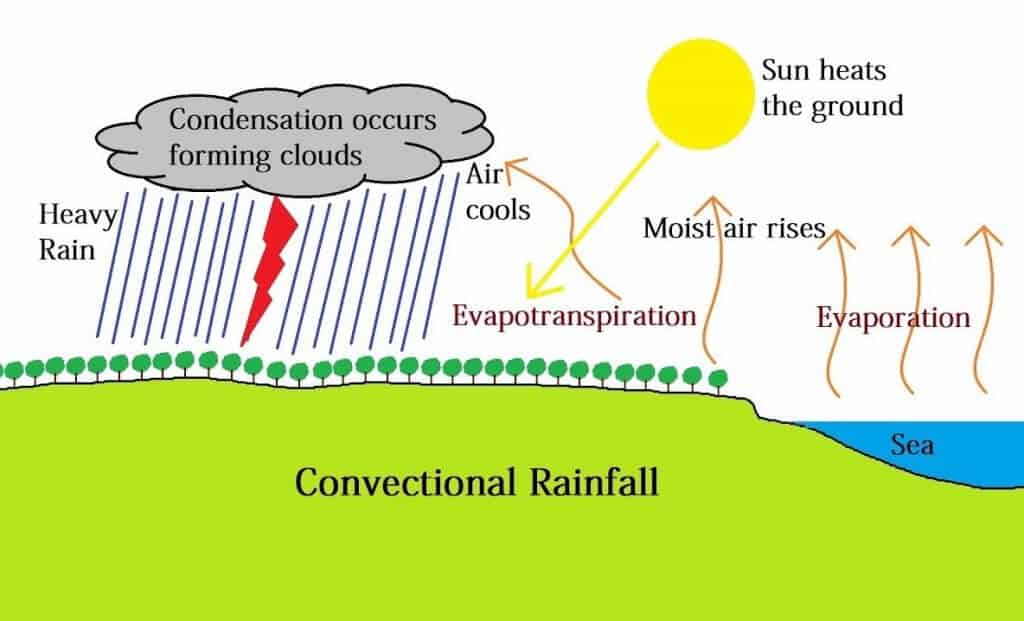
- Convectional precipitation results from the heating of the earth’s surface. The warm ground heats the air over it. As the air warms, the air molecules begin to move further apart. With increased distance between molecules, the molecules are less densely packed.
- Thus, the air becomes “lighter” and rises rapidly into the atmosphere. As the air rises, it cools. Water vapor in the air condenses into clouds and precipitation.
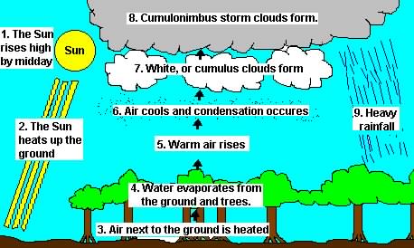
- It occurs in the areas of intense heat and abundant moisture. Solar radiation is the main source of heat to produce convectional currents in the air.
- The belt of doldrums and the equatorial region generally record this type of rainfall.
- This type of rainfall is not much effective for crops as most of the water is drained off in the form of surface drainage.
Orographic rainfall
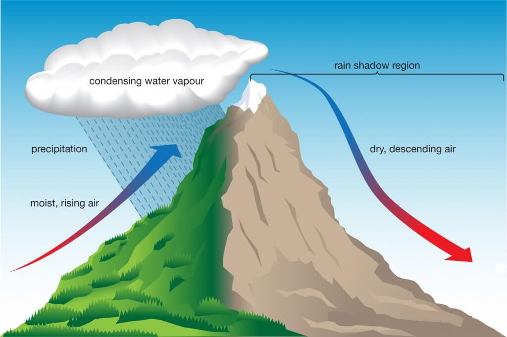
- Orographic precipitation results when warm moist air moving across the ocean is forced to rise by large mountains. As the air rises, it cools. As the air cools, the water vapor in the air condenses and water droplets form. Cloud forms and precipitation (rain or snow) occurs on the windward side of the mountain ranges.
- On the windward side also the amount of rainfall starts decreasing after a certain height.
- The air is now dry and rises over top of the mountain. As the air moves back down the mountain, it collects moisture from the ground via evaporation.
- This side of the mountain is called the leeward side. It receives very little precipitation.
Cyclonic or frontal rainfall
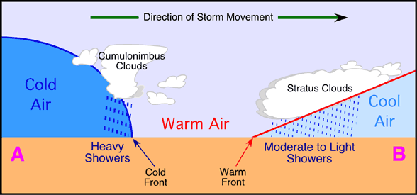
- Cyclonic rainfall occurs when deep and extensive air masses converge and move upward which leads to their adiabatic cooling.
- Cyclonic or Frontal precipitation results when the leading edge of a warm, moist air mass (warm front) meets a cool and dry air mass (cold front).
- The molecules in the cold air are more tightly packed together (i.e., more dense), and thus, the cold air is heavier than the warm air.
- The warmer air mass is forced up over the cool air. As it rises, the warm air cools, the water vapor in the air condenses, and clouds and precipitation result.
Monsoonal Rainfall
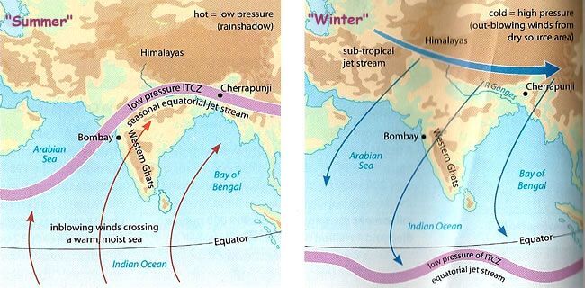
- This type of precipitation is characterized by seasonal reversal of winds that carry oceanic moisture (especially the south-west monsoon) with them and cause extensive rainfall in the south and southeast Asia.
World Distribution of Rainfall
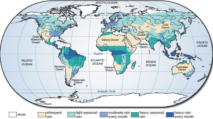
- Different places on the earth’s surface receive different amounts of rainfall in a year and that too in different seasons. In general, as we proceed from the equator towards the poles, rainfall goes on decreasing steadily.
- The coastal areas of the world receive greater amounts of rainfall than the interior of the continents. The rainfall is moreover the oceans than on the landmasses of the world because of being great sources of water.
- Between the latitudes 35° and 40° N and S of the equator, the rain is heavier on the eastern coasts and goes on decreasing towards the west. But, between 45° and 65° N and S of equator, due to the westerlies, the rainfall is first received on the western margins of the continents and it goes on decreasing towards the east.
- Wherever mountains run parallel to the coast, the rain is greater on the coastal plain, on the windward side and it decreases towards the leeward side.
- On the basis of the total amount of annual precipitation, major precipitation regimes of the world are identified as follows.
- The equatorial belt, the windward slopes of the mountains along the western coasts in the cool temperate zone, and the coastal areas of the monsoon land receive heavy rainfall of over 200 cm per annum.
- Interior continental areas receive moderate rainfall varying from 100 – 200 cm per annum. The coastal areas of the continents receive a moderate amount of rainfall.
- The central parts of the tropical land and the eastern and interior parts of the temperate lands receive rainfall varying between 50 – 100 cm per annum.
- Areas lying in the rain shadow zone of the interior of the continents and high latitudes receive very low rainfall – less than 50 cm per annum.
- The seasonal distribution of rainfall provides an important aspect to judge its effectiveness. In some regions, rainfall is distributed evenly throughout the year such as in the equatorial belt and in the western parts of cool temperate regions.
Virga
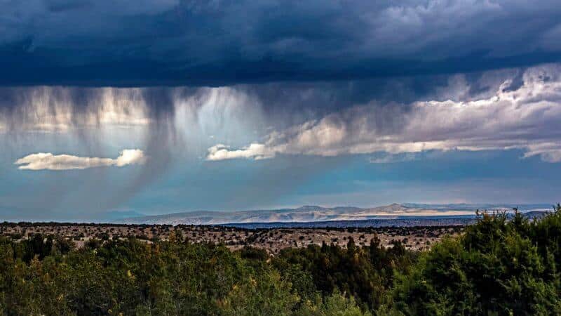
In meteorology, virga is an observable streak or shaft of precipitation falling from a cloud but evaporates or sublimates before reaching the ground.
FOG
Fog is simply a cloud on the ground. There is no physical difference between a cloud and fog, but there are important differences in how each forms. Most clouds develop as a result of adiabatic cooling in rising air, but only rarely is uplift involved in fog formation. Instead, mos fogs are formed either when air at Earth’s surface cools to below its dew point temperature or when enough water vapor is added to the air to saturate it. Four types of fog are generally recognized:
- A radiation fog results when the ground loses heat through radiation, usually at night. The heat radiated away from the ground passes through the lowest layer of air and into higher areas. The air closest to the ground cools as heat flows conductively from it to the relatively cool ground, and fog condenses in the cooled air at the dew point, often collecting in low areas.
- An advection fog develops when warm, moist air moves horizontally over a cold surface, such as snow-covered ground or cold ocean current. Air moving from sea to land is the most common source of advection fogs.
- An upslope fog, or orographic fog (from the Greek oro, “mountain”), is created by adiabatic cooling when humid air climbs a topographic slope.
- An evaporation fog results when water vapor is added to cold air that is already nea saturation.
DEW
- Dew usually originates from terrestrial radiation. Nighttime radiation cools objects (grass, pavement, automobiles, or whatever) at Earth’s surface, and the adjacent air is in turn cooled by conduction. If the air is cooled enough to reach saturation, tiny beads of water collect on the cold surface of the object. If the temperature is below freezing, ice crystals (white frost) rather than water droplets are formed.

0 Comments