- Fluvial landforms are those generated by running water, mainly rivers. The term fluvial derives from the Latin word ‘fluvius’ that means river.
- Fluvial landforms cover an enormous range of dimensions, from small features like rills to major continental-scale morpho-hydrological units like large rivers and their drainage basins.
- Rivers flowing to the oceans drain about 68 % of the Earth’s land surface.
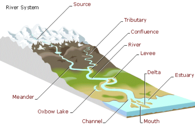
- The source of the river is generally found in an upland region with a slope down for the run-offs.
- Hence, the uplands form the catchment areas of the rivers & the crest of mountains becomes the divide or watershed from which the streams flow down the slope.
- The initial stream that exists as a consequence of the slope is called the consequent stream
- As the consequent stream wears down the surface, it is joined by several tributaries from either side.
- The drainage basin or watershed is a fundamental landscape unit in fluvial geomorphology. A dranage basin contains a primary, or trunk, river and its tributaries.
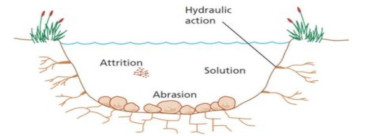
- Various aspects of fluvial erosive action include:
- Hydration: the force of running water wearing down rocks.
- Corrosion/Solution: chemical action that leads to weathering.
- Attrition: It involves wear & tear of transported material among them when they roll and collide into one another.
- Corrasion or abrasion: solid river load striking against rocks and wearing them down.
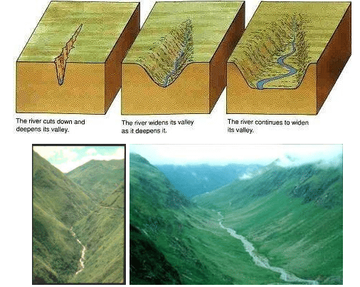
- Downcutting (vertical erosion): the erosion of the base of a stream (downcutting leads to valley deepening).
- Lateral erosion: the erosion of the walls of a stream (leads to valley widening).
- Headward erosion: erosion at the origin of a stream channel, which causes the origin to move back away from the direction of the stream flow, and so causes the stream channel to lengthen.
- Hydraulic Action: It involves Mechanical loosening & sweeping away of materials by river water. It occurs mainly by surging into the crevices & cracks of rocks & disintegrating them.
- Braiding: the main water channel splitting into multiple, narrower channel. A braided river, or braided channel, consists of a network of river channels separated by small, and often temporary, islands called braid bars. Braided streams occur in rivers with low slope and/or large sediment load.
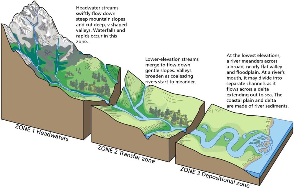
River course
Youth
- Streams are few during this stage with poor integration and flow over original slopes
- The valley developed is thus deep, narrow and distinctly V-shaped with no floodplains or with very narrow floodplains.
- Downcutting predominates over lateral corrasion
- Streams divides are broad and flat with marshes, swamp and lakes.
- Some of the outstanding features which are developed in this stage are gorges, canyons waterfalls, rapids and river capture etc.
Mature
- During this stage, streams are plenty with good integration.
- Lateral corrasion tends to replace vertical corrasion
- The valleys are still V-shaped but wide and deep due to an active erosion of the banks;
- Trunk streams are broad enough to have wider floodplains within which streams may flow in meanders confined within the valley.
- Swamps and marshes of youth stage, as well as flat and broad inter-stream areas, disappear. The stream divides turn sharp.
- Waterfalls and rapids disappear.
- Meander and slip off slopes are the characteristic features of this stage
Old
- The river moving downstream across a broad level plain is heavy with sediments.
- Vertical corrasion almost ceases in this stage though lateral corrasion still goes on to erode its banks further
- Smaller tributaries during old age are few with gentle gradients.
- Streams meander freely over vast floodplains. Divides are broad and flat with lakes, swamps and marshes.
- Depositional features predominate in this stage
- Most of the landscape is at or slightly above sea level
- Characteristic features of this stage are floodplains, oxbow lakes, natural levees and Delta etc.
Fluvial Landforms – Erosional
Splash Erosion
- Splash erosion or rain drop impact represents the first stage in the erosion process. Splash erosion results from the bombardment of the soil surface by rain drops.
- Rain drops behave as little bombs when falling on exposed or bare soil, displacing soil particles and destroying soil structure.
Sheet Erosion
- Sheet erosion occurs as a shallow ‘sheet’ of water flowing over the ground surface, resulting in the removal of a uniform layer of soil from the soil surface.
- Water moving fairly uniformly with a similar thickness over a surface is called sheet flow, and is the cause of sheet erosion.
Rills, and Gully
- A rill is a shallow channel in some soil, created by the erosion of flowing water. Rills can generally be easily removed by tilling the soil. When rills get large enough that they cannot easily be removed, they’re known as gullies.

Nala or Rivulet
- A rivulet is a small stream.
Ravine
- A ravine is a landform that is narrower than a canyon and is often the product of streambank erosion.
- Ravines are typically classified as larger in scale than gullies, although smaller than valleys.
River Valleys
- The extended depression on the ground through which a stream flows throughout its course is called a river valley.
- At different stages of the erosional cycle, the valley acquires different profiles
- Valleys start as small and narrow rills
- The rills will gradually develop into long and wide gullies
- The gullies will further deepen, widen and lengthen to give rise to valleys.
- Depending upon dimensions, shape, types and structure of rocks in which they are formed, many types of valleys like the V-shaped valley, gorge, canyon, etc. can be recognised.
I-shaped valley/Gorge
- When the sides of the valley are almost parallel to each other, they form an ‘I’ shape and hence, these valleys are known as I-shaped valley.
- A gorge is a deep and narrow valley with very steep to straight sides
- A gorge is almost equal in width at its top as well as its bottom.
- Gorges are formed in hard rocks.
- Example- Indus Gorge in Kashmir
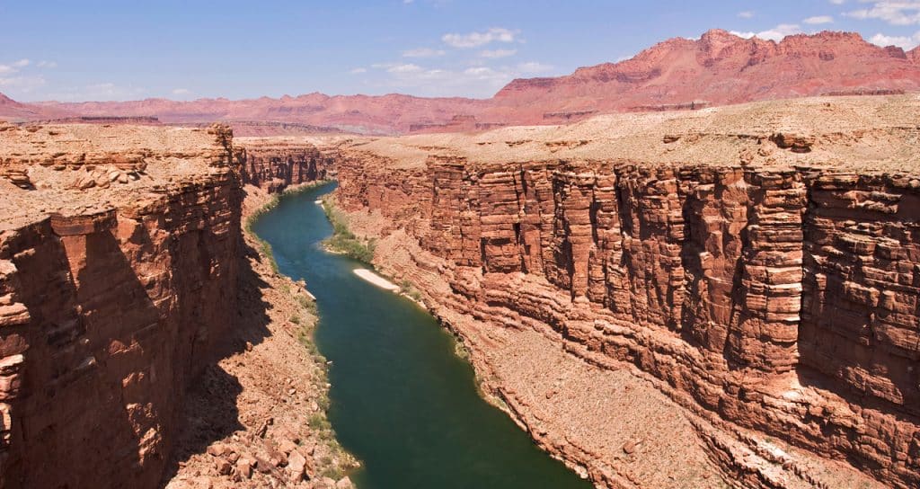
Canyon
- A canyon is a variant of the gorge.
- Unlike Gorge, a canyon is wider at its top than at its bottom.
- A canyon is characterised by steep step-like side slopes
- Canyons commonly form in horizontal bedded sedimentary rocks
- Example Grand Canyon carved by Colorado River, USA
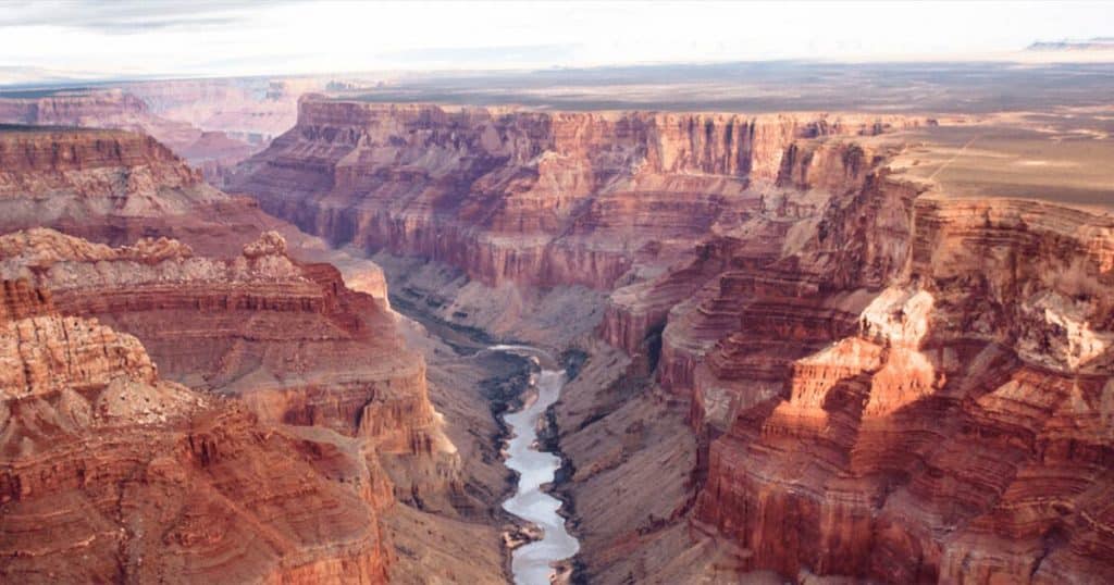
V-shape valley
- The river is very swift as it descends the steep slope, and the predominant action of the river is vertical corrasion
- The valley developed is thus deep, narrow and distinctly V-shaped
Interlocking spurs
- Interlocking spurs are projections of high land that alternate from either side of a V-shaped valley.
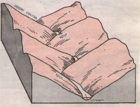
Waterfalls & Rapid
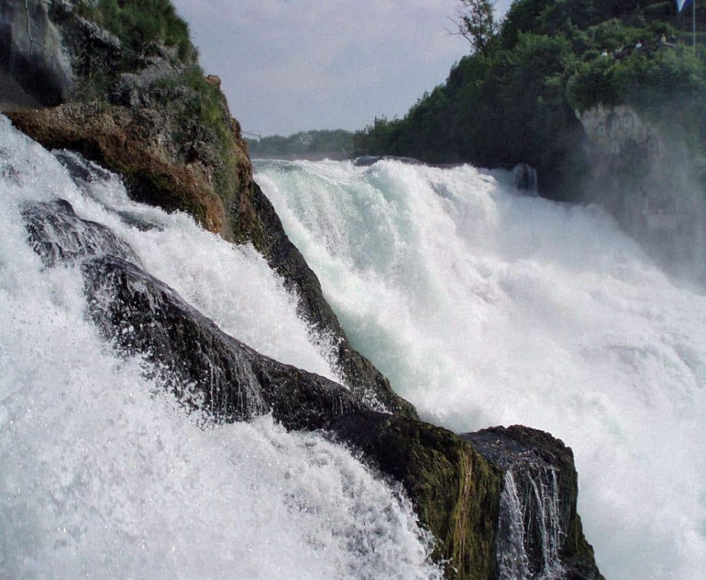
- When rivers plunge down in a sudden fall of some height, they are called waterfalls
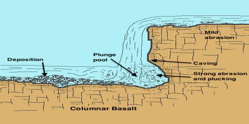
- Their great force usually wears out a plunge pool beneath
- Waterfalls are formed because of several factors like the relative resistance of rocks lying across the river, the relative difference in topographic reliefs e.g. in Plateau etc.
- A rapid is similarly formed due to an abrupt change in gradient of a river due to variation in resistance of hard and soft rocks traversed by a river
- Waterfalls are also transitory like any other landform and will recede gradually and bring the floor of the valley above waterfalls to the level below.
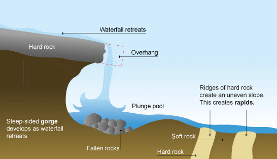
Potholes & Plunge Pool
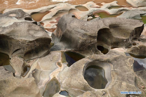
- Potholes are more or less circular depressions formed over the rocky beds of hill-streams, because of stream erosion aided by the abrasion of rock fragments.
- Once a small and shallow depression forms, pebbles and boulders get collected in those depressions and get rotated by flowing water and consequently the depressions grow in dimensions.
- Eventually, such depressions are joined leading to deepening of the stream valley.
- At the foot of waterfalls also, large potholes, quite deep and wide, form because of the sheer impact of water and rotation of boulders. These deep and large holes at the base of waterfalls are referred to as plunge pools.
- These pools also help in the deepening of valleys
Cataract
- Cataracts are waterfalls on very large rivers.
- The term cataract is usually applied to that section of a rapidly flowing river where the running water falls suddenly in a sheer drop. When the drop is less steep, the fall is known as a cascade.
- A cataract is a powerful, even dangerous, waterfall.
Ait/Eyot
- An ait or eyot is a small island.
- It is especially used to refer to river islands found on the River Thames and its tributaries in England.
- Aits are typically formed by the deposit of sediment in the water, which accumulates over a period of time.
- An ait is characteristically long and narrow, and may become a permanent island should it become secured and protected by growing vegetation.
- However, aits may also be eroded: the resulting sediment is deposited further downstream and could result in another ait. A channel with numerous aits is called a braided channel.
Incised or Entrenched Meanders
- Incised or entrenched meanders are found cut in hard rocks. They are very deep and wide.
- In streams that flow rapidly over steep gradients, normally erosion is concentrated on the bottom of the stream channel.
- Entrenched meander normally occurs where there is a rapid cutting of the river bed such that the river does not get to erode the lateral sides.
- Meander loops are developed over original gentle surfaces in the initial stages of development of streams and the same loops get entrenched into the rocks normally due to erosion or gradual uplift of the land over which they started.
- They are widened and deepened over a long period of time and can be found as deep gorges and canyons in the areas where hard rocks are found.
- They give an indication of the status of original land surfaces over which streams have developed.
- Incised meanders are said to be an impact of river rejuvenation.
Structural Benches
- Step like sequence of geomorphic surfaces
- Differential erosion of alternately arranged hard and soft rocks forming step-like valleys known as structural benches
- The benches formed due to differential erosion of alternate bands of hard and soft rock beds are called structural benches or terraces because of lithological control in the rate of erosion and consequent development of benches.

River Terraces
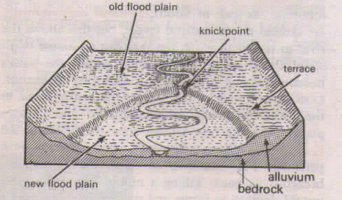
- River terraces refer to surfaces relating to old valley floor or floodplain levels.
- They may be bedrock surfaces without any alluvial cover or alluvial terraces consisting of stream deposits.
- River terraces are basically products of erosion as they result due to vertical erosion by the stream into its own depositional floodplain.
- There can be a number of such terraces. They are found at different heights indicating former river bed levels.
- The river terraces may occur at the same elevation on either side of the rivers in which case they are called paired terraces
Peneplain
- A peneplain (an almost plain) is a low-relief plain which is formed as a result of stream erosion
- The peneplain is meant to imply the representation of a near-final (or penultimate) stage of fluvial erosion during times of extended tectonic stability.
Drainage Basin
- Other terms that are used to describe drainage basins are catchment, catchment area, catchment basin, drainage area, river basin, and water basin.
- The drainage basin includes both the streams and rivers and the land surface.
- The drainage basin acts as a funnel by collecting all the water within the area covered by the basin and channelling it to a single point.
- In closed (endorheic) drainage basins the water converges to a single point inside the basin, known as a sink, which may be a permanent lake (e.g. Lake Aral, also known Aral Sea, Dead Sea), dry lake (some desert lakes like Lake Chad, Africa), or a point where surface water is lost underground (sinkholes in Karst landforms).
Drainage Divide
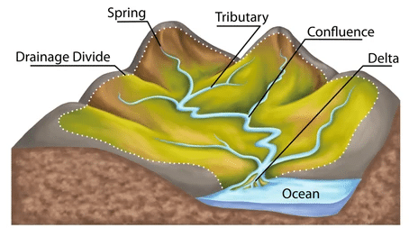
- Adjacent drainage basins are separated from one another by a drainage divide.
- Drainage divide is usually a ridge or a high platform.
- Drainage divide is conspicuous in case of youthful topography (Himalayas), and it is not well marked in plains and senile topography.
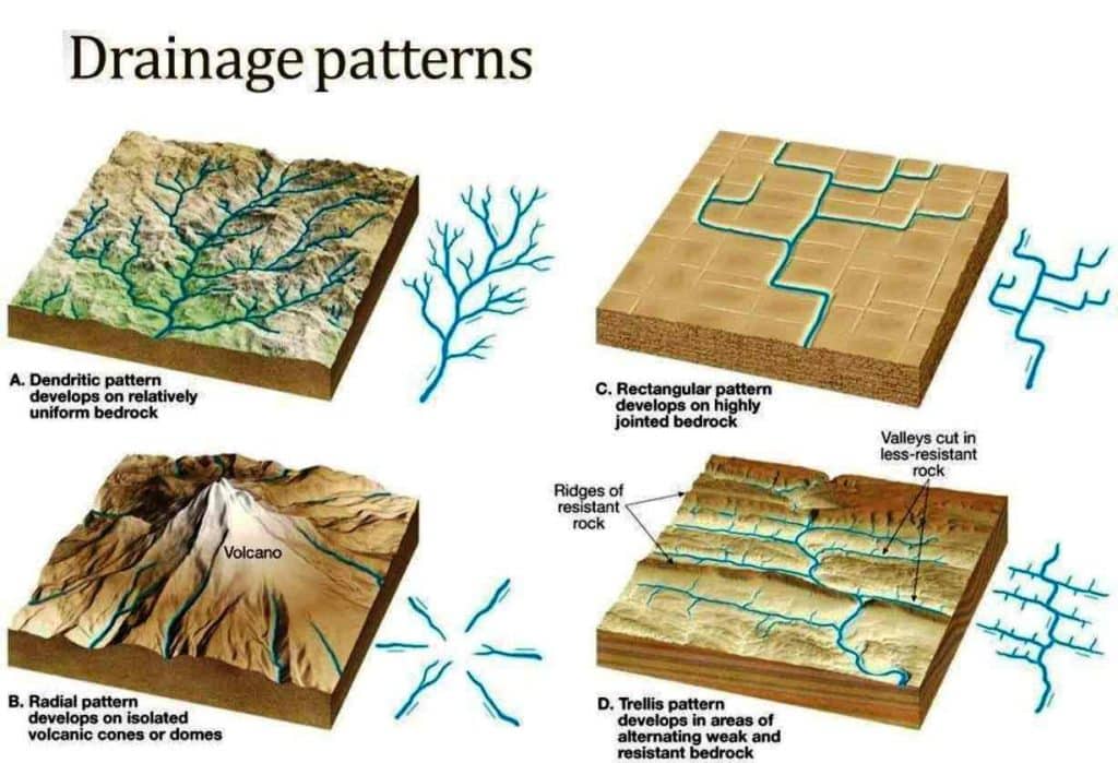
Drainage Patterns
- The drainage pattern of a stream refers to the typical shape of a river course as it completes its erosional cycle
- They are governed by the topography of the land, resistance and strength of base rocks and the gradient of the land
- There are various types of drainage patterns which are described briefly as below:-
- Dendritic drainage pattern
- It is the most common form of drainage system.
- The drainage pattern resembling the branches of a tree is known as dendritic In a dendritic system, there are many contributing streams, which are then joined together into the tributaries of the main river
- The examples of Dendritic Pattern include the rivers of northern plain such Indus.
- Trellis drainage pattern
- In the trellis drainage pattern, the primary tributaries of rivers flow parallel to each other and they are joined by secondary tributaries at the right angle.
- The geometry of a trellis drainage system is similar to that of a common garden trellis used to grow vines.
- Trellis drainage is characteristic of folded mountains,
- Examples of trellis pattern include the drainage system of the Appalachian Mountains in North America and Seine and its tributaries in Paris basin (France) etc.
- Parallel drainage pattern
- A parallel drainage system is a pattern of rivers caused by steep slopes with some relief.
- The parallel drainage pattern is observed in a uniformly sloping region where the tributaries seem to be running parallel to each other.
- A parallel pattern sometimes indicates the presence of a major fault that cuts across an area of steeply folded bedrock.
- Examples of this system include the rivers of Lesser Himalaya
- Rectangular drainage pattern
- Rectangular drainage develops on rocks that are of approximately uniform resistance to erosion, but which have two directions of joining at approximately right angles.
- In the rectangular drainage pattern, the mainstream curve at right angles and the tributaries join the mainstream at right angles.
- Example Colorado river the USA
- Angular drainage pattern
- Angular drainage pattern is commonly observed in foothill regions.
- Angular drainage patterns form where bedrock joints and faults intersect at more acute angles than rectangular drainage patterns. Angles are both more and less than 90 degrees
- the mainstream is joined by the tributaries at acute angles.
- Radial drainage pattern
- When the rivers originate from a hill and flow in all directions, the drainage pattern is known as radial .
- Volcanoes usually display excellent radial drainage. Other geological features on which radial drainage commonly develops are domes and laccoliths.
- The rivers originating from the Amarkantak range present a good example of it.
- Centripetal drainage pattern
- When the rivers discharge their waters from all directions in a lake or depression, the pattern is known as centripetal .
- Examples – streams of Ladakh, Tibet and Loktak Lake in Manipur (India)
- Annular drainage pattern
- In an annular drainage pattern streams follow a roughly circular or concentric path along a belt of weak rock, resembling in plan a ring-like pattern.
- Example of such system include Black Hill streams of South Dakota, USA
Fluvial Landforms – Depositional
- Fluvial Depositional landforms are made by river sediments brought down by extensive erosion in the upper course of the rivers.
- Rocks and cliffs are continually weathered and eroded in the youth stage or upper course of the river.
- The river moving downstream on a level plain brings down a heavy load of sediments from the upper course.
- The decrease in stream velocity in the lower course of the river reduces the transporting power of the streams which leads to deposition of this sediment load.
- Coarser materials are dropped first and finer silt is carried down towards the mouth of the river
- This depositional process leads to the formation of various depositional landforms through fluvial action such as Delta, Levees and Flood Plain etc.
Alluvial Fans and Cones
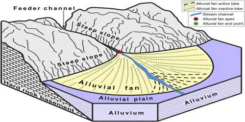
- An alluvial fan is a cone-shaped depositional landform built up by streams, heavy with sediment load.
- Alluvial fans are formed when streams flowing from mountains break into foot slope plains of low gradient.
- Normally very coarse load is carried by streams flowing over mountain slopes. This load gets dumped as it becomes too heavy to be carried over gentler gradients by the streams
- Furthermore, this load spreads as a broad low to a high cone-shaped deposit called an alluvial fan that appears as a series of continuous fans.
- Alluvial fans in humid areas show normally low cones with a gentle slope from head to toe and they appear as high cones with a steep slope in arid and semi-arid climates.
Floodplains
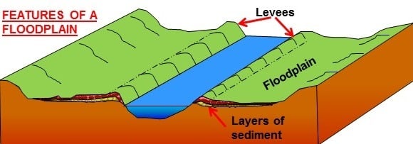
- Floodplain is a major landform of river deposition.
- Deposition develops a floodplain just as erosion makes valleys.
- Rivers in the lower course carry large quantities of sediments
- Large sized materials are deposited first when stream channel breaks into a gentle slope.
- Sand, silt and clay and other fine sized sediments are carried over gentler channels by relatively slow-moving waters
- During annual or sporadic floods, these materials are spread over the low lying adjacent areas. A layer of sediments is thus deposited during each flood, gradually building up a floodplain
- In plains, channels shift laterally and change their courses occasionally leaving cut-off courses which get filled up gradually by relatively coarse deposits.
- The flood deposits of spilt waters carry relatively finer materials like silt and clay.
- Active Floodplain – A riverbed made of river deposits is the active floodplain.
- Inactive Floodplain – The floodplain above the bank is an inactive floodplain. Inactive floodplain above the banks basically contains two types of deposits flood deposits and channel deposits.
- Delta plains – The floodplains in a delta are called delta plains.
Doab
- Doab is the tract of land between two converging rivers.
- Doab is a term used in South Asia particularly in India and Pakistan to refer to ” tongue” or tract of land lying between two converging rivers.
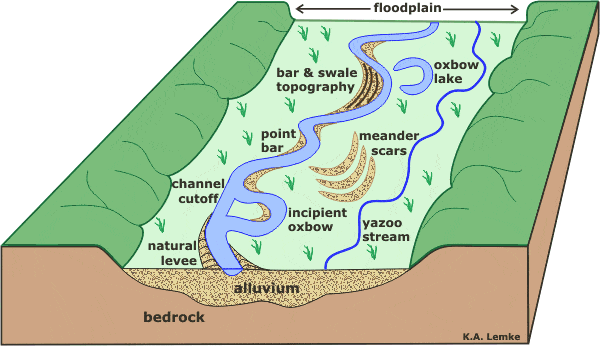
Natural Levees
- This is an important landform associated with floodplains.
- They are found along the banks of large rivers.
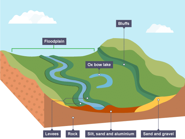
- They are low, linear and parallel ridges of coarse deposits along the banks of rivers on both sides due to deposition action of the stream, appearing as natural embankments.
- At the time of flooding, the water is spilt over the bank. As the speed of flow of the water comes down, large sized sediments with high specific gravity are dumped along the bank as ridges.
- They are high nearer the banks and slope gently away from the river.
- Generally, the levee deposits are coarser
- When rivers shift laterally, a series of natural levees can form.
- Artificial embankments are formed on the levees to minimize the risk of the floods.
- But sudden bursts in the banks due to the pressure of water can cause disastrous floods.
- An example of such flood can be seen in Hwang Ho river which is also called China s sorrow .
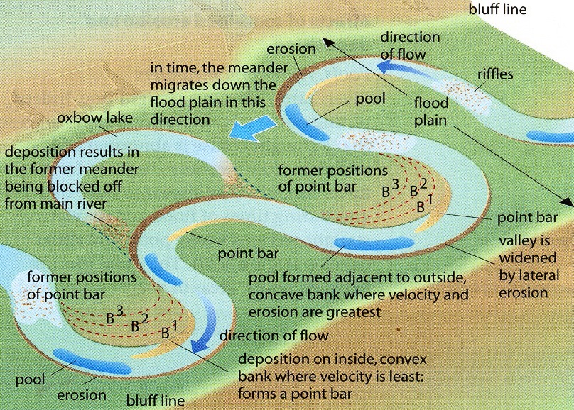
Point Bars & Cut Banks
- Point Bar is also associated with floodplain
- Point bars are also known as meander bars.
- A point bar is a depositional feature
- It is formed by alluvium that accumulates in a linear fashion on the inside bends of streams and rivers below the slip-off slope.
- They are found on the convex side of meanders of large rivers.
- They are almost uniform in profile and in width and contain mixed sizes of sediments.
- Long and narrow depressions can be found in between the point bars where there is more than one ridge
- Rivers build a series of them depending upon the water flow and supply of sediment.
- As the point bars are built by the rivers on the convex side, erosion takes place on the concave side of the bank.
- Cut banks are found on the outside of a bend in a river. Cut banks are caused by the moving water of the river wearing away the earth.
Meanders
- In large flood and delta plains, rivers rarely flow in straight courses. Loop-like channel patterns called meanders develop over flood and delta plains
- Normally, in meanders of large rivers, there is active deposition along the convex bank and undercutting along the concave bank.
- If there is no deposition and no erosion or undercutting, the tendency to meander is reduced.
- The concave bank is known as a cut-off bank which shows up as a steep scarp and the convex bank presents a long, gentle profile and is known as the slip-off bank
Oxbow Lake
- In the lower course of a river, meanders become very much more pronounced
- As meanders grow into deep loops, the same may get cut-off due to erosion at the inflexion points and are left as independent water bodies, known as ox-bow lakes.
- Through subsequent floods that may silt up the lake, oxbow lakes are converted into swamps in due course of time. It becomes marshy and eventually dries up

Riffle and Pool
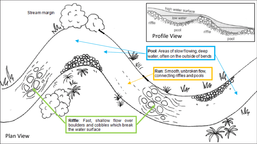
- Pools: An area of the stream characterized by deep depths and slow current. Pools are typically created by the vertical force of water falling down over logs or boulders. The movement of the water carves a deeper indentation in the stream bed. Pools are important because they can provide depth and still water.
- Riffles: An area of stream characterized by shallow depths with fast, turbulent water. The riffles are short segments of the stream where water flow is agitated by rocks. The rocky bottom provides protection from predators, food deposition, and shelter. Riffle depths vary depending upon stream size but can be as shallow as 1 inch or deep as 1 meter. The turbulence and streamflow result in high dissolved oxygen concentration.
Bluff
- A bluff is a small, rounded cliff that usually overlooks a body of water, or where a body of water once stood.
- Bluff is a ridge of land that extends into the air.
Braided Channels
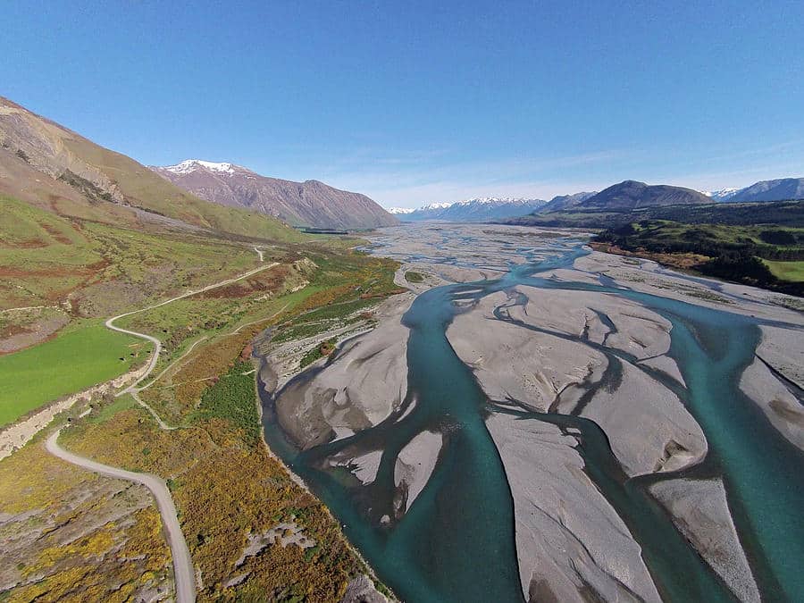
- A braided channel consists of a network of river channels divided into multiple threads and separated by small and often temporary islands called eyots .
- Braided channels are commonly found where water velocity is low and the river is heavy with sediment load
- Deposition and lateral erosion of banks are essential for the formation of the braided pattern.
- There is the formation of central bars due to selective deposition of coarser material which diverts the flow towards the banks causing extensive lateral erosion
- As the valley widens due to continuous lateral erosion, the water column is reduced and more and more materials get deposited as islands and lateral bars developing a number of separate channels of water flow.
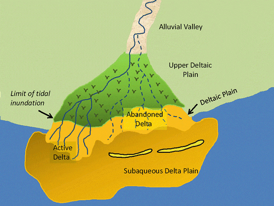
Delta
- Deltas are fan-shaped alluvial areas, resembling an alluvial fan
- This alluvial tract is, in fact, a seaward extension of the floodplain
- The load carried by the rivers is dumped and spread into the mouth of the river at sea. Further, this load spreads and piles up as a low cone
- Unlike in alluvial fans, the deposits making up deltas are very well sorted with clear stratification. The coarsest sediments are deposited first and the finer sediments are carried out further, into the sea.
- Deltas extend sideways and seaward at an amazing rate
- As the delta grows, the river distributaries continue to increase in length and Delta continues to build up into the sea.
- Some deltas are extremely large. For example, the Ganges delta is as big as the whole west of Malaysia
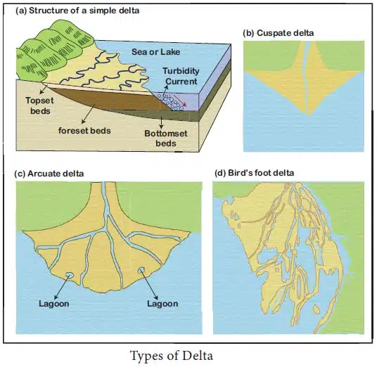
- Types of Deltas: There are great variations in size, shape, growth, and importance of Deltas. A great number of factors influence the eventual formation of deltas such as depth of the river, sedimentation, sea-bed, character of tides, waves, and currents, etc. owing to these factors several types of deltas can be found.
- Bird s foot delta It s a kind of delta featuring long, stretching distributary channels, which branch outwards resembling the foot of a bird. Deltas that are less subjected to wave or tidal action culminates to a bird s foot delta. Example the Mississippi River has a bird s foot delta extending into the Gulf of Mexico
- Arcuate delta Arcuate is the most common type of delta. This is a fan-shaped delta. It s a curved or bowed delta with a convex margin facing the sea. Arcuate deltas have a smooth coastline due to the action of the waves and the way they are formed. Examples – The Nile, Ganges, and Mekong river deltas
- Cuspate delta A few rivers have tooth-like projections at their mouth, known as the cuspate delta. Cuspate deltas are formed where the river flows into a stable water body (sea or ocean). The sediments brought down by the rivers collide with the waves. As a result, Sediments are spread evenly on either side of its channel. Example Ebro river delta in Spain
- Estuarine delta some rivers have their deltas partly submerged in the coastal waters to form an estuarine delta. This may be due to a drowned valley because of a rise in sea level. Example Amazon river delta
- Conditions favorable for the formation of delta
- Active vertical and lateral erosion in the upper course of the river to provide extensive sediments to be eventually deposited as deltas
- The coast should be sheltered preferable tideless
- The sea adjoining the delta should be shallow or else the load will disappear in the deep waters
- There should be no large lakes in the river to filter off the sediments
- There should be no strong current running at right angles to the river mouth, washing away the sediments
