In this article you are going to read an important topic of climatology i.e. Cyclones And Anticyclones – Geography For UPSC.
Two important mechanisms of energy transfer— circulation patterns in the atmosphere and in the oceans. Shift some of the warmth of the low latitudes toward the high latitudes, and so moderate both the warmth of low latitudes and the cold of the high latitudes.
Both the atmosphere and oceans act as enormous thermal engines, with their latitudinal imbalance of the energy driving the currents of air and water, which in turn transfer energy and somewhat modify the imbalance.
Of the two mechanisms of global energy transfer, by far the more important is the general circulation of the atmosphere.
Air moves in an almost infinite number of ways, but there is a broad planetary circulation pattern that serves as a general framework for moving warm air pole ward and cool air equator ward.
Some 75 to 80 percent of all horizontal energy transfer is accomplished by atmospheric circulation.
Atmospheric Circulation
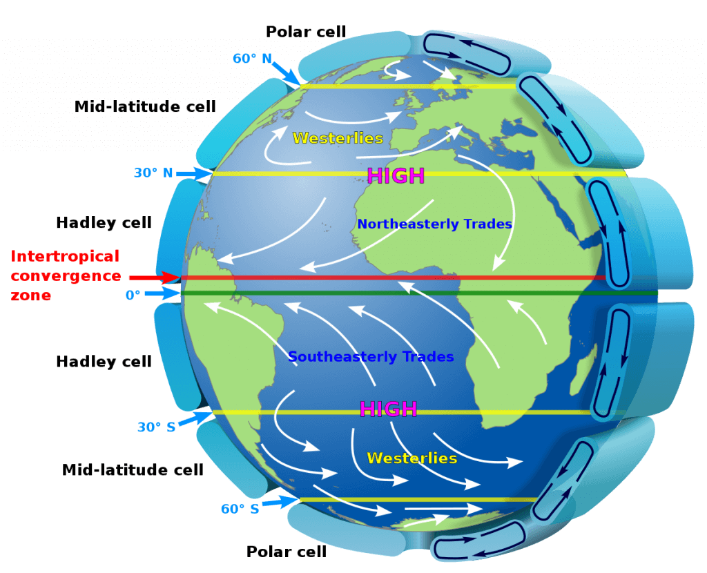
The movement of air in the atmosphere is called atmospheric circulation.
Earth’s atmospheric circulation is an important transfer mechanism for both energy and mass. The process occurs to balance the energy surplus of tropics and the energy deficit of poles.
The atmospheric circulation takes place by the movement of air in the atmosphere. It can be horizontal and vertical.
The horizontal movement of air is called a Wind. Winds are generally named after the direction from which they are coming. For example, a wind blowing from sea towards land is called sea breeze, a wind blowing from East to West is called an Easterly, etc.
The vertical movement of air is called an updraft if the air parcel is moving up, and a downdraft if the air parcel is moving down.
Oceanic Circulation:
Winds disturb the surface of the ocean with swells and waves. Wind can also propel the surface of the water to move forward in the form of a current. Surface ocean currents can flow at about 1 to 2 percent of wind speed, meaning that water in a surface current might travel some tens or even hundreds of kilometers in a day.
A close relationship exists between the general circulation patterns of the atmosphere and oceans. It is the wind blowing over the surface of the water that is the principal force driving the major surface ocean currents. However, the influence works both ways: energy stored in the oceans has important effects on patterns of
atmospheric circulation.
Impact of pressure and Wind
The influence of atmospheric pressure on the landscape is significant but indirect. This influence is manifested mostly by wind, which response to pressure changes. The wind has the energy to transport solid particles in the air and thus has a visible component of its activity. Vegetation may bend in the wind and loose material such as dust or sand may be shifted from one place to another.
The results are nearly always short-run and temporary, however, and usually have no lasting effect on the landscape except at the time of a severe storm. Nevertheless, pressure and wind are major elements of weather and climate, and their interaction with other atmospheric components and processes cannot be overestimated.
The atmosphere is made up of gases that have mass, and so the atmosphere has weight because this mass is pulled toward Earth by gravity. Atmospheric pressure is the force exerted by the weight of these gas molecules on a unit of area of Earth’s surface or on any other body.
Atmospheric pressure is measured with instruments called barometers.
The millibar (mb) is an expression of force per surface area. One millibar is defined as 1000 dynes per square centimeter (1 dyne is the force required to accelerate 1 gram of a mass 1 centimeter per second per second). Average sea-level pressure is 1013.25 millibars. The S.I. the unit used to describe pressure is the pascal (Pa; 1 Pa = newton/m2) and in some countries, the kilopascal is used in meteorology (kPa; 1 kPa = 10 mb).
Isobars are lines connecting points of equal atmospheric pressure.
Coriolis effect and Wind
The atmosphere is virtually always in motion. Air is free to move in any direction, its specific movements being shaped by a variety of factors. Some airflow is weak and brief; some are strong and persistent.
Atmospheric motions often involve both horizontal and vertical movement.
Wind refers to horizontal air movement; it has been described whimsically as “air in a hurry.”
The term wind is applied only to horizontal movements. Although both vertical and horizontal motions are important in the atmosphere, much more air is involved in horizontal movements than in vertical.
The direction of wind movement is determined principally by the interaction of three factors: the pressure gradient, the Coriolis effect, and friction.
Pressure Gradient: If there is higher pressure in one area than in another, air will begin to move from the higher pressure toward the lower pressure in response to the pressure gradient force.
Coriolis effect: It is a deflecting force experienced due to the rotation of the earth. Because of Coriolis, the air appears to turn towards its right in the northern hemisphere and towards its left in the southern hemisphere. The Coriolis always acts in the perpendicular direction of the motion of air. It is zero at the equator and increases towards the poles.
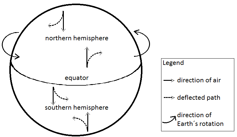
Everyone is familiar with the unremitting force of gravity—its powerful pull toward the center of Earth influences all vertical motion that takes place near Earth’s surface. Much less well known, however, because of its inconspicuous nature, is a pervasive influence on the direction of objects moving horizontally around Earth—a phenomenon known as the Coriolis effect.
Due to the Coriolis effect, all things moving over the surface of Earth or in Earth’s atmosphere appear to drift sideways as a result of Earth’s rotation beneath them. As a result of the rotation of Earth, the path of any free-moving object appears to deflect to the right in the Northern Hemisphere, and to the left in the Southern Hemisphere.
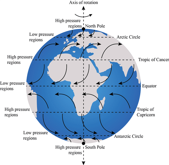
The following are four basic points to remember about the Coriolis effect:
- Regardless of the initial direction of motion, any freely moving object appears to deflect to the right in the Northern Hemisphere and to the left in the Southern Hemisphere.
- The apparent deflection is strongest at the poles and decreases progressively toward the equator, where the deflection is zero.
- The Coriolis effect is proportional to the speed of the object, and so a fast-moving object is deflected more than a slower one.
- The Coriolis effect influences direction of movement only; it does not change the speed of an object.
Friction force: It is a drag force which causes resistance to the motion of air as it flows on the surface. It decreases with height above the surface. The effect of surface friction is felt up to the height of 500m above the surface. It varies with surface texture, wind speed, time of day and year, and atmospheric conditions.
Cyclones and Anticyclones
High-Pressure Wind Patterns: A high-pressure center is known as an anticyclone, and the flow of air associated with it is described as being anticyclonic.
The four patterns of anticyclonic circulation are shown in Figure –
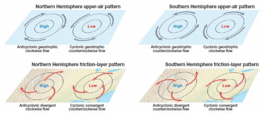
- In the upper atmosphere of the Northern Hemisphere, the winds move clockwise in a geostrophic manner parallel to the isobars.
- In the friction layer (lower altitudes) of the Northern Hemisphere, there is a divergent clockwise flow, with the air spiraling out away from the center of the anticyclone.
- In the upper atmosphere of the Southern Hemisphere, there is a counterclockwise, geostrophic flow parallel to the isobars.
- In the friction layer of the Southern Hemisphere, the pattern is a mirror image of the Northern Hemisphere, with air diverging in a counterclockwise pattern.
Low-Pressure Wind Patterns: Low-pressure centers are called cyclones, and the associated wind movement is said to be cyclonic.
As with anticyclones, Northern Hemisphere cyclonic circulations are mirror images of their Southern Hemisphere counterparts:
- In the upper atmosphere of the Northern Hemisphere, air moves counterclockwise in a geostrophic pattern parallel to the isobars.
- In the friction layer of the Northern Hemisphere, a converging counterclockwise flow exists.
- In the upper atmosphere of the Southern Hemisphere, a clockwise, geostrophic flow occurs paralleling the isobars.
- In the friction layer of the Southern Hemisphere, the winds converge in a clockwise spiral.
Vertical Movement within Cyclones and Anticyclones: A prominent vertical component of air movement is also associated with cyclones and anticyclones.
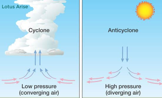
Air descends in anticyclones and rises in cyclones. Such motions are particularly notable in the lower troposphere. The anticyclonic pattern can be visualized as upper air sinking down into the center of the high and then diverging near the ground surface. Opposite conditions prevail in a low-pressure center, with the air converging horizontally into the cyclone and then rising.
Cyclones and rising air are associated with clouds, whereas anticyclones and descending air are associated with clear conditions.
Air Mass
An air mass is a distinctive, homogenous, body of air in terms of temperature, humidity and lapse rate that takes on the moisture and temperature characteristic of its source region. For example, if an air mass is formed over Canada it will be very cold and dry.
Classification of air masses:
Air masses are classified on the basis of source region, latitudinal position, and temperature and moisture properties.
The two main categories of air masses are:
- Tropical or sub-tropical
- Polar or sub- polar
The sub division of these groups is made according to whether the source region is oceanic or continental. They are also sub-divided according to what modifications the air masses experience as they move from their source regions.
To identify the different types of air masses, letter symbols are placed first in the designation. Following that the source region is indicated: Tropical (T), Polar (P), Equatorial (E), Arctic (A) and Antarctic (AA). ‘k’ (for the German kalt) for the air colder than the underlying surface or ‘w’ for the air warmer than the surface.
On the basis of origin it can be maritime and continental.
| Air mass | Symbol | Source Region | Properties |
| Maritime Equatorial | mE | warm ocean in equatorial zone | Unstable, warm, very moist |
| Maritime Tropical | mT | warm ocean in the tropical zone | warm, moist |
| Continentel Tropical | cT | Subtropical deserts | warm, dry |
| Maritime Polar | mP | Midlatitude oceans | cool, moist(winter) |
| Continental Polar | cP | Nothern continental interiors | cool, dry(winter) |
| Continental Arctic and Continental Antarctic | cAA | Regions near north and south poles | Very cold, very dry, very stable |
The border between the two air masses with contrasting physical properties is known as fronts. A warm front marks the leading edge of a sector of warm air. Cold front denotes the influx of cold air.
Fronts
The development of fronts and frontal waveforms are known as Frontogenesis. Frontogenesis occurs in well-defined areas.
When unlike air masses meet, they do not mix readily; instead, a boundary zone called a front develops between them. A front is not a simple two-dimensional boundary.
A typical front is a narrow three-dimensional transition zone several kilometers or even tens of kilometers wide. Within this zone, the properties of the air change rapidly. The frontal concept was developed by Norwegian meteorologist during World War I, and the term front was coined because these scientists considered the clash between unlike air masses to be analogous to a the confrontation between opposing armies along a battlefront.
As the more “aggressive” air mass advances at the expense of the other, some mixing of the two occurs within the frontal zone, but for the most part the air masses retain their separate identities as one is displaced by the
other.
Types of Fronts: The most conspicuous difference between air masses is usually temperature.
A cold front forms where an advancing cold air mass meets and displaces warmer air, whereas a
warm front forms where an advancing warm air mass meets colder air.
A cold front forms when a cold air mass is actively under-riding a warm air mass. As a cold front advances, the warm air ahead of it is forced upward. This displacement often creates cloudiness and relatively heavy precipitation along and immediately behind the ground level position of the front.
A warm front forms when a warm air mass is actively overriding a cold air mass. As warm air rises above cooler air, widespread cloudiness and precipitation develop along and in advance of the ground-level position of the front. Higher and less dense clouds are often dozens or hundreds of kilometers ahead of the ground-level position of the front.
Stationary Fronts
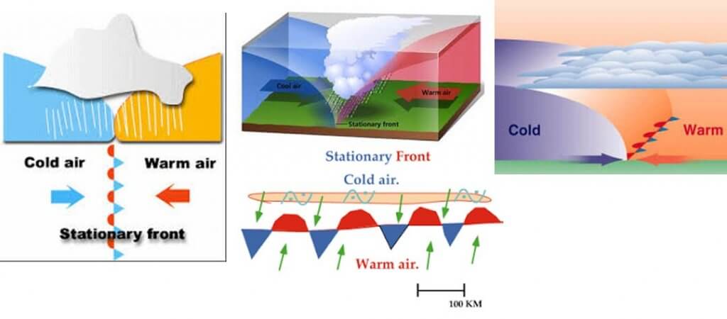
When neither air mass displaces the other or if a cold front or warm front “stalls”—their common boundary is called a stationary front.
It is difficult to generalize about the weather along such a front, but often gently rising warm air produces limited precipitation similar to that along a warm front.
As shown, stationary fronts are portrayed on a weather map by a combination of warm and cold front symbols, alternating on opposite sides of the line—cold air is opposite the triangles and warm air opposite the half circles.
Occluded Fronts
A fourth type of front, called an occluded front, is formed when a cold front overtakes a warm front. Occluded fronts are shown on a weather map by a combination of warm and cold front symbols, alternating on the same side of the line.

Cyclones may be classified as –
- Temperate cyclones
- Tropical cyclones
Temperate Cyclones
The temperate cyclones occur in the mid latitude of both the hemisphere. These cyclones are born along the polar front, particularly in the region of Icelandic and Aleutian sub –polar low pressure areas in the northern hemisphere.
Cyclogenesis: Development and strengthening of mid latitude wave cyclone is known as cyclogenesis. This is called the polar front theory, given by Bjerkness in 1918. On an average, a temperate cyclone takes 3-10 days to progress through the stages of development.
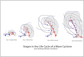
The period of cyclone from its inception to its termination is called the ‘life cycle of cyclone’ which is completed through six successive stages.
Stage A: the first stage involves the convergence of two air masses of contrasting physical properties and direction.
Stage B: it is called ‘incipient stage’ during which the warm and cold air masses penetrate into the territories of each other.
Stage C: it is mature when the cyclone is fully developed and isobars become almost circular.
Stage D: warm sector is narrowed in extent due to advancement of cold front at a faster rate than a warm front, and cold front comes nearer to warm front.
Stage E: this stage starts with the occlusion of cyclone when the advancing cold front finally overtakes the warm front and occluded front is formed.
Stage F: in the final stage, warm sector completely disappears, occluded front is eliminated and ultimately cyclone dies out.
Characteristics of Temperate Cyclone:
- The temperate cyclone moves counter clockwise in northern hemisphere and clockwise in southern hemisphere.
- It may be 1600km wide, thus a single cyclone may cover the whole Europe.
- The isobars are elliptical in shape.
- The cold air mass moves faster than the warm air mass.
- These cyclones move at a gentle pace of 5-25km per hour.
- They give light showers which are highly beneficial for the crops and human health and efficiency.
- In the ending part of cyclone there is thunder and lightning.
- Each cyclone is followed by a clear weather.
Tropical Cyclones
Tropical cyclone gets its energy from latent heat of condensation. The energy in an average hurricane may be equivalent to more than 10,000 atomic bombs the size of Nagasaki bomb.
These storms range in size from a few kilometers to several hundred kilometers in diameter. In the middle is an eye that can be as large as 65km across. The total area involved may be as much as 52000 sq km. the tropical cyclones originate between 10° and 25 degree latitudes in both the hemispheres.
Conditions conducive for tropical cyclone:
- There should be continuous supply of abundant warm and moist air.
- The sea temperature in lower latitude should be around 26-27 degree C.
- Existence of weak tropical depression.
- There should be presence of coriolis force.
Characteristics of tropical cyclones:
- The isobars are generally circular, and close to each other resulting into steep pressure gradient.
- They may be a thousand kilometers in diameter and about 15km in height.
- The central area is designated as an ‘eye’ of cyclone. The eye of cyclone is surrounded by clouds so high and dense that the day time sky above looks dark. The central part of the tropical cyclone has clear sky in which the air descends from the above.
- They do not have fronts.
- They derive their energy from the latent heat.
- The clouds in the cyclone are cumulonimbus having vertical extension up to about 12- 15km.
- They give torrential rainfall.
- Majority of tropical cyclones decay when they come over the land or when they recurve northward over oceans.
Origin of Tropical Cyclone:
The origin of the tropical cyclones is not well understood. A tropical cyclone generally develops from a small tropical depression. Tropical depressions forms easterly waves, areas of lower pressure within the easterly trade winds.
When air containing the disturbance is heated by the proximity of tropical waters with a temperature of about 26 degree C or more, circular winds begin to blow in the vicinity of the wave, and some of the warm humid air is forced upward. Condensation begins, and the storm takes shape. Under ideal conditions, the embryo storm reaches hurricane status (i.e. with wind speed in excess of 118 km per hr) in two to three days.
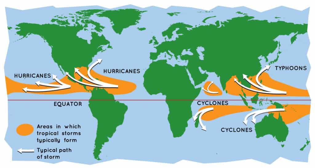
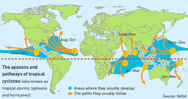
Places of occurrence:
- The Caribbean Sea and the Gulf of Mexico.
- The northwest pacific from the Philippines to the China Sea.
- The Pacific Ocean west of Mexico.
- The South Indian Ocean east of Madagascar.
- The North Indian Ocean in the Bay of Bengal.
- The Arabian Sea.
Nomenclature:
Large tropical cyclones are called Hurricanes in the North Atlantic and Eastern Pacific, Typhoons in China, Taiphoo in Japan, cyclone or chakravaat in the Bay of Bengal, Baguio in the Philippines, and Willi Willies in Australia.
Cyclone, Hurricane, Typhoon
Hurricane, cyclone and typhoon are different terms for the same weather phenomenon: torrential rain and maximum sustained wind speeds (near center) exceeding 119 kilometers per hour:
- In the western North Atlantic, central and eastern North Pacific, Caribbean Sea, and the Gulf of Mexico, such a weather phenomenon is called “hurricanes“.
- In the western North Pacific, it is called “typhoons“
- In the Bay of Bengal and the Arabian Sea, it is called “cyclones“
- In the western South Pacific and southeast India Ocean, it is called “severe tropical cyclones”
- In the southwest Indian Ocean, it is called “tropical cyclones”.
How are Cyclones named?
Cyclones that form in every ocean basin across the world are named by the regional specialized meteorological centers (RSMCs) and Tropical Cyclone Warning Centres (TCWCs).
There are six RSMCs in the world, including the India Meteorological Department (IMD), and five TCWCs.
Lists and names of Cyclones are maintained and updated by an international committee of the World Meteorological Organisation (WMO). According to WMO guidelines, countries in every region are supposed to give names for cyclones.
- IMD, one of the six Regional Specialised Meteorological Centres (RSMC) in the world, is mandated to issue advisories and name tropical cyclones in the north Indian Ocean region.
- The advisories are issued to 13 member countries under WMO/ESCAP Panel including Bangladesh, India, Iran, Maldives, Myanmar, Oman, Pakistan, Qatar, Saudi Arabia, Sri Lanka, Thailand, United Arab Emirates, and Yemen.
Benefits of naming : Naming of tropical cyclones helps the scientific community, disaster managers, media and general masses to
- Identify each individual cyclone.
- Create awareness of its development.
- Remove confusion in case of simultaneous occurrence of tropical cyclones over a region.
- Remember a tropical cyclone easily,
- Rapidly and effectively disseminate warnings to a much wider audience.
Naming of the Tropical Cyclones
- The WMO/ESCAP Panel on Tropical Cyclones (PTC) at its 27th Session held in 2000 in Muscat, Oman agreed in principle to assign names to the tropical cyclones in the Bay of Bengal and the Arabian Sea.
- The naming of the tropical cyclones over the north Indian Ocean commenced from September 2004.
- This list contained names proposed by then eight member countries of WMO/ESCAP PTC, viz., Bangladesh, India, Maldives, Myanmar, Oman, Pakistan, Sri Lanka, and Thailand.
- The requirement for a fresh list of tropical cyclones including representation from five new member countries: Iran, Qatar, Saudi Arabia, United Arab Emirates, and Yemen (total 13 member countries) was tabled during the 45th session of WMO/ESCAP, held in September 2018. The session was hosted by Oman.
Panel on Tropical Cyclones
- The World Meteorological Organization (WMO) and the Economic and Social Commission for Asia and the Pacific (ESCAP) jointly established the Panel on Tropical Cyclones (PTC)in 1972 as an intergovernmental body.
- Its membership comprises countries affected by tropical cyclones in the Bay of Bengal and the Arabian Sea.
- The Panel is one of the five regional tropical cyclone bodies established as part of the WMO Tropical Cyclone Programme (TCP) which aims at promoting and coordinating the planning and implementation of measures to mitigate tropical cyclone disasters on a worldwide basis.
- For this purpose, there are Regional Specialized Meteorological Centre (RSMC)- Tropical cyclone and Tropical Cyclone Warning Centres (TCWC) for different regions.
- The main objective of the WMO/ESCAP Panel on Tropical Cyclones is to promote measures to improve tropical cyclone warning systems in the Bay of Bengal and the Arabian Sea.
Quiz:
Q1. Consider the following statements regarding Cyclones.
- Cyclones are sustained by very strong low-pressure areas at their core.
- Very few cyclones originate in the Arabian Sea, but they are relatively strong compared to those emerging in the Bay of Bengal.
Which of the above statements is/are correct?
a) 1 only
b) 2 only
c) Both 1 and 2
d) Neither 1 nor 2
Solution: a)
Cyclones are sustained by very strong low-pressure areas at their core. Winds in surrounding areas are forced to rush towards these low-pressure areas.
Though cyclones are common in June, very few of them originate in the Arabian Sea. Most of them are found in the Bay of Bengal. In the last 120 years for which records are available, just about 14% of all cyclonic storms, and 23% of severe cyclones, around India have occurred in the Arabian Sea. Arabian Sea cyclones are also relatively weak compared to those emerging in the Bay of Bengal.

0 Comments