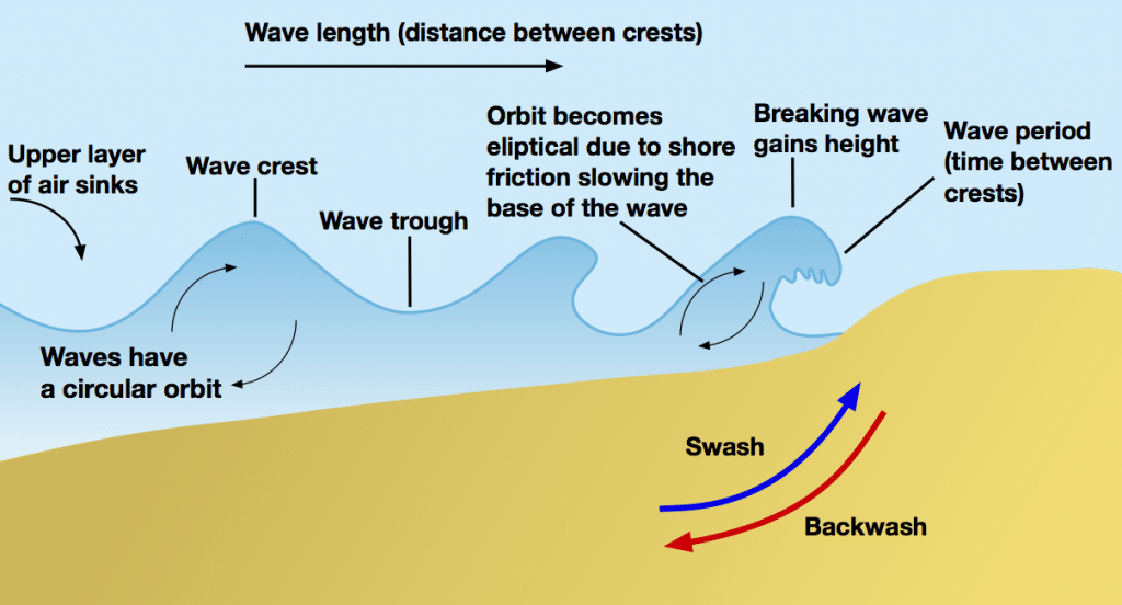
- The most powerful agents of marine erosion are waves which originate due to the sweeping of winds over the water surface, setting up a series of undulating swells surging forward.
- On approaching shallow water near the shores, their speed is reduced and the waves are curved and refracted against the alignment of the coast.
- The shallow water when is less than the height of the waves, check their forward movement, the wave crest curl over and breaks into shore.
- Water that finally rushes up the beach and hurls rock debris against the land is called swash, with the water that retreats or is sucked back is called backwash.
- Another element in offshore drift is an undertow, which flows near the bottom away from the shore.
- This current exerts the pulling effect which can be dangerous for sea bathers.
Types of Erosion
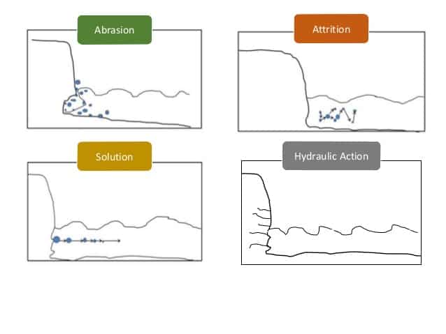
Sea waves, aided by winds, currents, tides, and storms carry on the erosional and depositional processes. There are 4 types of erosion:
Corrasion or Abration
- Waves armed with rock debris of all sizes and shapes charge against the base of the cliffs and wear them back by corrosion.
- On coming tides and waves complete the work by sweeping the eroded material into the sea.
Attrition
- The constantly moving waves that transport beach materials such as boulders, pebbles, shingles, and fine sand, also hurl these materials against each other until they are broken into small pieces.
- The grinding and polishing of these materials against the cliff faces and against each other is largely responsible for the fine sand which forms the beaches.
- In their forward surge, waves splashing against the coast may enter the joints and crevices in the rocks.
- The air imprisoned inside is immediately compressed but when the waves retreat, the compressed air expands with explosive violence.
Hydraulic Action
- Hydraulic action is the erosion that occurs when the motion of water against a rock on the surface produces mechanical weathering. Most generally, it is the ability to move water (flowing or waves) to dislodge and transport rock particles.
- Hydraulic action is distinguished from other types of water facilitated erosion, such as static erosion where water leaches salts and floats off organic material from unconsolidated sediments, and from chemical erosion more often called chemical weathering.
- It is a mechanical process, in which the moving water current flows against the banks and bed of a river, thereby removing rock particles.
Solvent Action
- The solvent or chemical action of waves is another mode of erosion, but it is pronounced only in case of soluble rocks like limestone and chalk.
- On limestone coasts, the solvent action of the sea water on calcium carbonate sets up chemical changes in the rocks and disintegration takes place.
Marine transportation
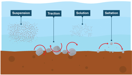
- Solution – minerals are dissolved in the water and carried along in solution.
- Suspension – fine light material is carried along in the water.
- Saltation – small pebbles and stones are bounced along the sea bed.
- Traction – large boulders and rocks are rolled along the sea bed.
Marine Landforms – Erosional
Headlands and Bays
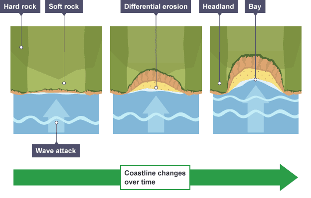
- Cliffs along the coastline do not erode at the same pace. When a stretch of coastline is formed from different types of rock, headlands and bays can form.
- Bands of soft rock such as clay and sand are weaker therefore they can be eroded quickly. This process forms bays. A bay is an inlet of the sea where the land curves inwards, usually with a beach. Hard rock such as chalk is more resistant to the processes of erosion. When the softer rock is eroded inwards, the hard rock sticks out into the sea, forming a headland.
- Erosional features such as wave-cut platforms and cliffs can be found on headlands since they are more open to the waves. Bays are more sheltered with constructive waves which deposit sediment to form a beach.
Cliffs and Wave-Cut platforms
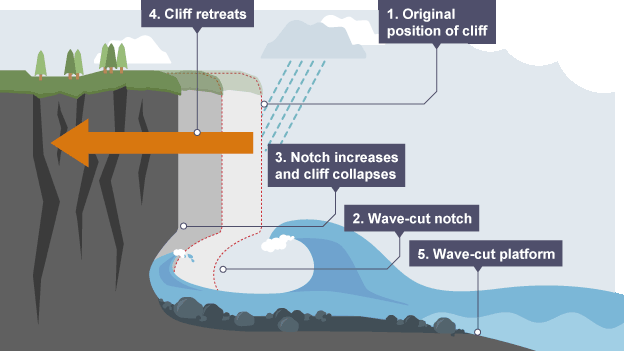
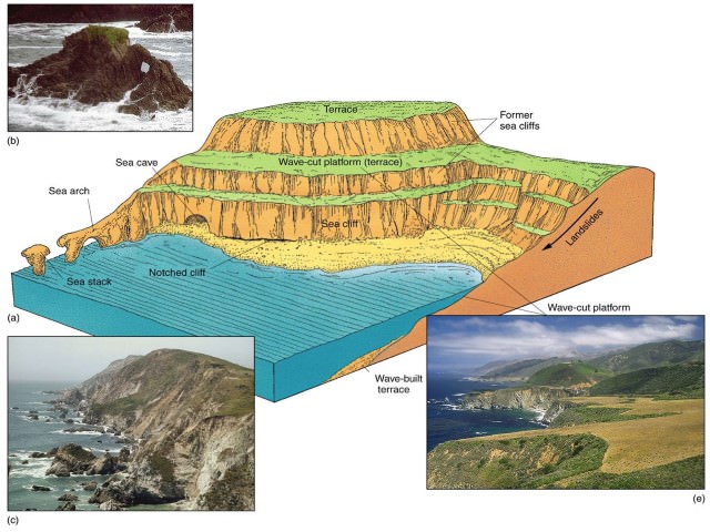
- Cliffs are shaped through erosion and weathering. Soft rock erodes quickly and forms gentle sloping cliffs, whereas hard rock is more resistant and forms steep cliffs. A wavecut platform is a wide gently sloping surface found at the foot of a cliff.
- A wave-cut platform is formed when the following occurs:
- The sea attacks the base of the cliff between the high and low water mark.
- A wave-cut notch is formed by erosional processes such as abrasion and hydraulic action – this is a dent in the cliff usually at the level of high tide.
- As the notch increases in size, the cliff becomes unstable and collapses, leading to the retreat of the cliff face.
- The backwash carries away the eroded material, leaving a wave-cut platform.
- The process repeats. The cliff continues to retreat.
Caves, Arches, Stacks, and Stumps
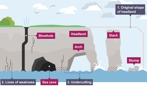
- Caves, arches, stacks and stumps are erosional features that are commonly found on a headland.
- Cracks are widened in the headland through the erosional processes of hydraulic action and abrasion.
- As the waves continue to grind away at the crack, it begins to open up to form a cave.
- The cave becomes larger and eventually breaks through the headland to form an arch.
- The base of the arch continually becomes wider through further erosion, until its roof becomes too heavy and collapses into the sea. This leaves a stack (an isolated column of rock).
- When a portion of the sea arch collapses, the remaining column-like structure is called a stack, skarry or chimney rock.
- The stack is undercut at the base until it collapses to form a stump.
Ria, and Cove
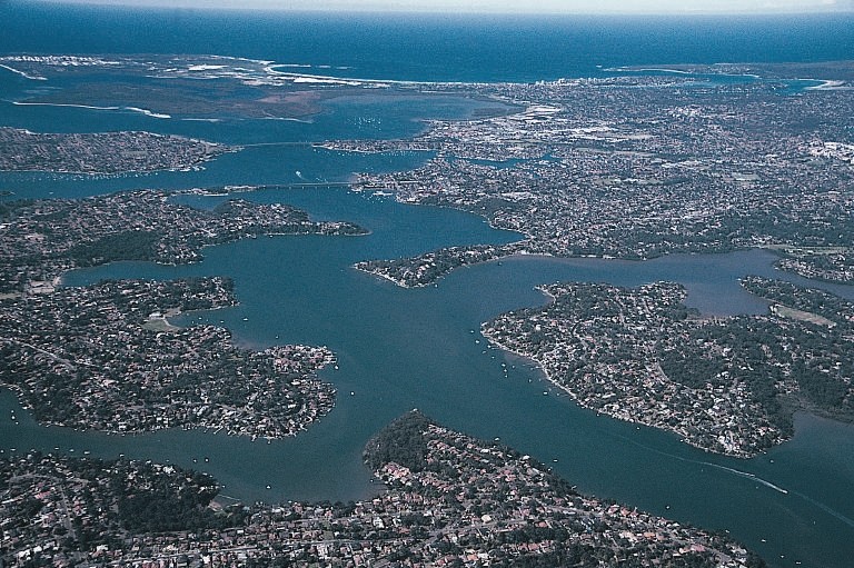
- A ria is a coastal inlet formed by the partial submergence of an unglaciated river valley. It is a drowned river valley that remains open to the sea.
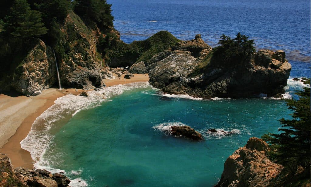
- A cove is a small bay or inlet with a sheltered or restricted entrance. It can also be the entrance to a creek or other small body of water.
- Coves are usually formed by the erosion of soft rock formation, leaving hard rock that can form a circular or oval bay with a small entrance.
- A cove is generally less than 1000 feet across and can be much smaller, sometimes less than 100 feet in diameter.
Geos and Gloups (blowholes or marine geyser)
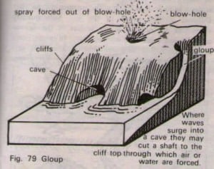
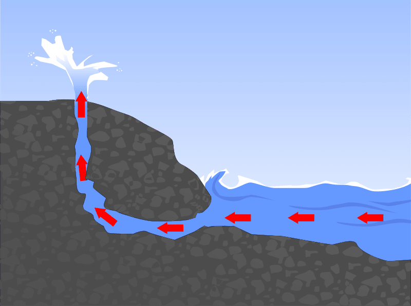
- The occasional splashing of the waves against the roof of a cave may enlarge the joints when air is compressed & released repeatedly inside them.
- A natural shaft is thus formed which may eventually pierce through the surface.
- Waves breaking into the cave may force water or air out of this hole. Such a shaft is termed as Gloup or blow hole.
- The enlargement of blow-holes & continual action of waves weakens the cave roof.
- When the cave roof collapses, a long, narrow creek may develop known as Geos.
Chasms
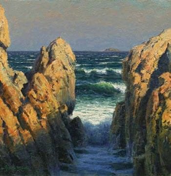
- These are narrow, deep indentations (a deep recess or notch on the edge or surface of something) carved due to headward erosion (downcutting) through vertical planes of weakness in the rocks by wave action.
- With time, further headward erosion is hindered by lateral erosion of chasm mouth, which itself keeps widening till a bay is formed.
Creek, and Inlet
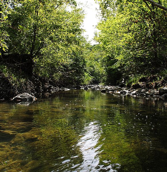
- Creek: natural stream of water normally smaller than and often tributary to a river. creek is a narrow, sheltered waterway, especially an inlet in a shoreline or channel in a marsh.
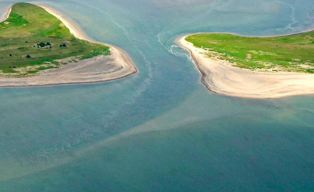
- Inlet: An inlet is an indentation of a shoreline, usually long and narrow, such as a small bay or arm, that often leads to an enclosed body of salt water, such as a sound, bay, lagoon, or marsh.
Marine Landforms – Depositional
When water loses its energy, any sediment it is carrying is deposited. The build-up of deposited sediment can form different features along the coast.
Beaches
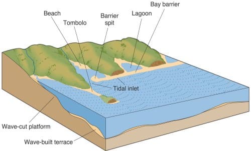
- Beaches are made up of eroded material that has been transported from elsewhere and then deposited by the sea. For this to occur, waves must have limited energy, so beaches often form in sheltered areas like bays. Constructive waves build up beaches as they have a strong swash and a weak backwash.
- Sandy beaches are usually found in bays where the water is shallow and the waves have less energy. Pebble beaches often form where cliffs are being eroded, and where there are higher energy waves.
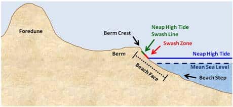
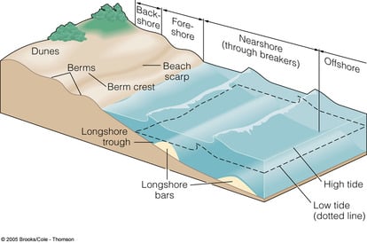
- A cross-profile of a beach is called the beach profile. The beach profile has lots of ridges called berms. They show the lines of the high tide and the storm tides. A sandy beach typically has a gently sloping profile, whereas a shingle beach can be much steeper. The size of the material is larger at the top of the beach, due to the high-energy storm waves carrying large sediment. The smallest material is found nearest the water as the waves break here and break down the rock through attrition.
Spits and Hook
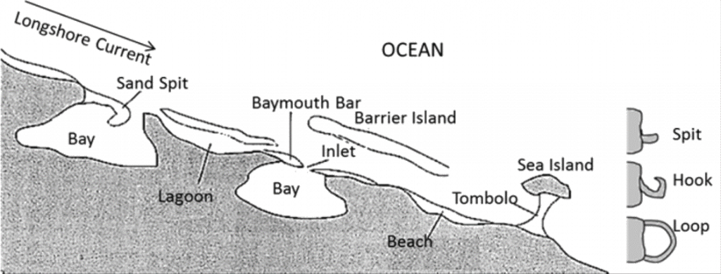
- A spit is an extended stretch of sand or shingle jutting out into the sea from the land. Spits occur when there is a change in the shape of the landscape or there is a river mouth.
- This is how spits are formed:
- Sediment is carried by longshore drift.
- When there is a change in the shape of the coastline, deposition occurs. A long thin ridge of material is deposited. This is the spit.
- A hooked end can form if there is a change in wind direction.
- Waves cannot get past a spit, therefore the water behind a spit is very sheltered. Silts are deposited here to form salt marshes or mudflats.
Tombolos & Dumb Ball
- A tombolo is a sandy isthmus. Sometimes, islands are connected with mainland by a bar called tombolo.
- If two islands are connected to each other by a bar is called Dumb Ball.
Marine Dunes & Dune Belts
- With the force of on-shore winds, a large amount of coastal sand is driven landwards forming extensive marine dunes that stretch into dune belts
- Their advance inland may engulf farms, roads & even the entire villages;
- Hence to arrest the migration of dunes, sand binding species of grass & shrubs, such as marram grass & pines are planted.
Comments
Post a Comment