To understand the mechanism of the Indian Monsoon, You will need to revise the few concepts of climatology and oceanography, i.e. ITCZ, Jet Stream, Ocean Currents, Southern Oscillation, and the Indian Ocean Dipole. So, Let’s do this!
Indian Monsoon
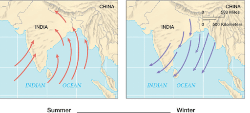
- The word ‘monsoon’ is believed to have originated from the Arabic word for season ‘mawsim’. Monsoons are basically seasonal winds that reverse their direction according to the change in season. They are hence, periodic winds.
- The monsoons travel from the sea to the land in summers and from land to the sea during winters, hence, are a double system of seasonal winds.
- Some scholars tend to treat the monsoon winds as land and sea breeze on a large scale.
- Historically the monsoons have been very important because these winds were used by traders and seafarers to move from place to place. Though there is monsoon in the Indian subcontinent, central-western Africa, Southeast Asia, and a few other places, the winds are most pronounced in the Indian subcontinent.
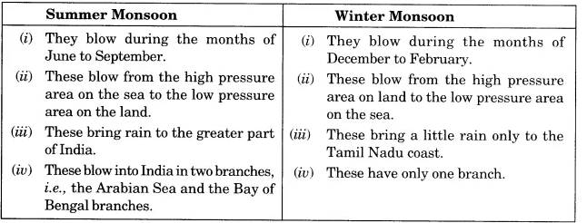
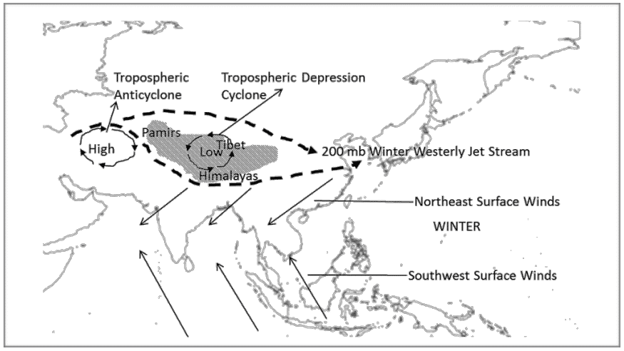
- India gets southwest monsoon winds in the summers and northeast monsoons during the winters. The former arise because of the formation of an intense low-pressure system over the Tibetan Plateau. The latter arises due to the high-pressure cells that are formed over the Siberian and Tibetan plateaus.
- South-west monsoons bring intense rainfall to most of the regions in India and north-east monsoons bring rainfall to mainly south-eastern coast of India (Southern coast of Seemandhra and the coast of Tamil Nadu.).
- Countries like India, Indonesia, Bangladesh, Myanmar etc. receive most of the annual rainfall during south-west monsoon season where as South East China, Japan etc., during north-east rainfall season.
Mechanism of Indian Monsoon
The monsoons are experienced in the tropical area roughly between 20° N and 20° S. Monsoon is a complex meteorological phenomenon. The origin of monsoons is not fully understood. There are several theories that tried to explain the mechanism of monsoons. To understand the mechanism of the monsoons, the following facts are important
Thermal Concept
- Halley, a noted astronomer, made a hypothesis that the primary cause of the Indian monsoon circulation was the differential heating effects of the land and the sea. According to this concept, monsoons are the extended land breeze and sea breeze on a large scale. During winter the huge landmass of Asia cools more rapidly than the surrounding oceans with the result that a strong high-pressure centre develops over the continent. On the other hand, the pressure over adjacent oceans is relatively lower. As a consequence the pressure- gradient is directed from land to sea. Therefore there is an outflow of air from the continental landmass towards the adjacent oceans so that it brings cold, dry air towards the low latitudes.
- In summer, the temperature and pressure conditions are reversed. Now, the huge landmass of Asia heats quickly and develops a strong low-pressure centre. Moreover, the poleward shift of the Intertropical Convergence Zone (ITCZ) to a position over Southern Asia reinforces the thermally induced low-pressure centre. The pressure over the adjacent oceans being high, a seato-land pressure gradient is established. The surface airflow is, therefore, from the highs over the oceans towards the lows over the heated land. The air that is attracted into the centers of low pressure from over the oceans is warm and moist.
- Halley’s concept is criticized on the following lines:
- It fails to explain the intricacies of monsoon such as the sudden burst of monsoon, breaks in monsoon, the spatial and temporal distribution of monsoon. The low-pressure areas are not stationary. The rainfall is not only convectional but a mix of orographic, cyclonic, and convectional rainfall.
Recent Concept about the Origin of Indian Monsoon
After world war second, the upper atmospheric circulation has been studied significantly. It is now believed that the differential heating of sea and land alone can’t produce monsoon circulation. Apart from it, the recent concept of monsoon rely heavily on the role of
- Himalayas and Tibetan plateau as a physical barrier and a source of high-level heat.
- Circulation of upper air jet streams in the troposphere.
- Existence of upper air circum-polar whirl over north and south poles in the troposphere.
- The occurrence of ENSO (El-Nino and Southern Oscillation) in the South Pacific ocean
- Walker cell in Indian Ocean.
- Indian Ocean Dipole
Role of the Himalayas and Tibetan Plateau
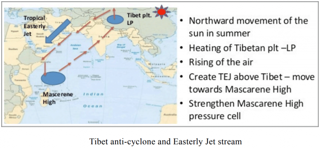
- In the 1970s, it was found that the Tibet plateau plays a crucial role in initiating the monsoon circulation. The plateau of Tibet extends over an area of about 4.5 million sq. km. The average height of these highlands is 4000 m. Due to its enormous height, it receives 2-3oC more insolation than the neighboring areas. The heating of these areas leads to clockwise air circulation in the middle troposphere and two-wind streams originate from this area. One of these wind streams blows southward and develops into the tropical easterly jet stream (TEJ). The other stream blows in an opposite direction towards the North Pole and becomes the westerly jet stream over Central Asia.
Role of Jet Stream
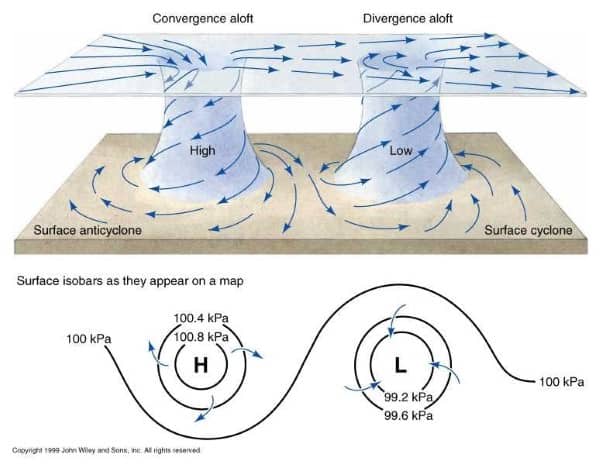
- As already discussed, the sub-tropical westerly jet stream is bifurcated by the high-land Tibet in winters. The northward branch extends up to 20N-35N. Tropical easterly jet stream (TEJ), that branch off from anticyclone developed over Tibet, sometimes reaches to the tip of Peninsular India. Apart from this, Jet speed winds are also reported over other parts of Peninsular. This jet descends over the Indian Ocean and intensifies its high-pressure cell known as Mascarene High. It is from this high-pressure cell that the onshore winds start blowing towards the thermally induced low-pressure area, developed in the northern part of the Indian subcontinent. After crossing the equator such winds become south-westerly and are known as the southwesterly summer monsoon.
Role of ENSO
- The Indian monsoon is also influenced by EL-Nino, southern oscillation, and Somalian current. We know that El Nino is the reversal of normal conditions in the Pacific Ocean’s sea surface temperature. Though there is no direct correlation between bad monsoon and El Nino, but both are generally associated. There are years when India faced severe drought and those are not El -Nino years and vice-versa. Southern Oscillation is the see-saw pattern of atmospheric pressure between the eastern and western Pacific oceans. The oscillation has a period varying from 2-7 years. It is measured with Southern Oscillation Index (SOI) by measuring the pressure difference between two points in the Pacific Ocean (Tahiti and Darwin). A negative value of SOI implies high pressure over the north Indian Ocean during the winter season and a poor monsoon.
- The Somalian current changes its direction of flow after every six months. During the North-East Monsoon, the Somali Current flows to the south-west, while during the South-West Monsoon it is a major western boundary current, comparable with the Gulf Stream. Normally, there remains a low-pressure area along the eastern coast of Somalia. In exceptional years, after every six or seven years, the low-pressure area in the western Arabian Sea becomes a high-pressure area. Such a pressure reversal results into a weaker monsoon in India.
Walker Cell
- It is observed that there is an east-west atmospheric circulation over the tropical oceanic regions. Such circulation in the Pacific Ocean is generally called walker cell. However, many scientists use the term ‘walker cell’ for all east-west circulations in different oceans. Walker cell is associated with southern oscillation and its strength fluctuates with that of the Southern Oscillation Index (SOI). With a high positive SOI, there would be a zone of low atmospheric pressure over Australia and the Indonesian archipelago. The rising air from this region deflects in the upper atmosphere in both directions towards Africa and South America. In the Indian Ocean, the air descends down at a high-pressure zone from where surface winds blow as Southwest monsoon towards the Indian sub-continent in summers. During La-Nina Indian ocean branch of the walker cell gets strengthened and surface winds are more intense. La-Nina condition is generally associated with good monsoon.
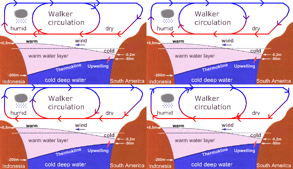
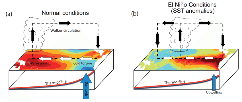
- During the appearance of El-Nino or negative SOI, the ascending branch of the Walker cell shifts to the central regions of the Pacific Ocean from the western pacific region (Figure 8). In a result, the Indian Ocean cell shifts towards the east. The surface winds or Southwest monsoon winds are weaker than normal conditions.
Indian Ocean Dipole
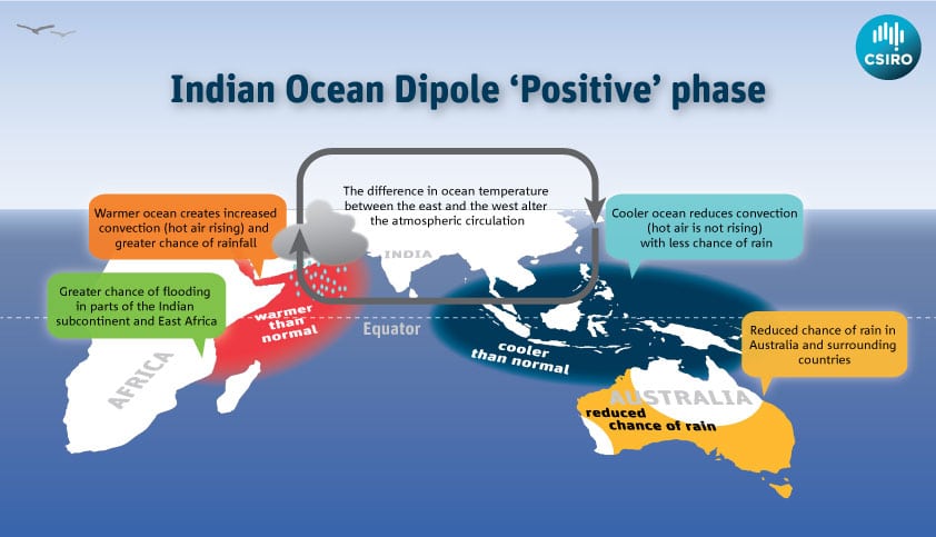
- The Indian Ocean Dipole (IOD) also known as the Indian Nino is a coupled Ocean-atmosphere phenomenon in the Indian Ocean. It is defined by the difference in sea surface temperature between two areas (or poles, hence a dipole) – a western pole in the Arabian Sea (western Indian Ocean) and an eastern pole in the eastern Indian Ocean south of Indonesia. The IOD Involves a periodic oscillation of sea-surface temperatures (SST), between “positive”, “neutral” and “negative” phases. A positive phase sees greater-than-average sea-surface temperatures and greater precipitation in the western Indian Ocean region, with a corresponding cooling of waters in the eastern Indian Ocean—which tends to cause droughts in adjacent land areas of Indonesia and Australia. The negative phase of the IOD brings about the opposite conditions, with warmer water and greater precipitation in the eastern Indian Ocean, and cooler and drier conditions in the west.
- The IOD is one aspect of the general cycle of global climate, interacting with similar phenomena like the El Niño-Southern Oscillation (ENSO) in the Pacific Ocean. Positive and negative IOD both have been seen coupled with La Nina. Thus, there is no direct correlation between IOD and ENSO.
- The IOD also affects the strength of monsoons over the Indian subcontinent. Positive IOD which is associated with warm sea-surface temperatures of the western Indian Ocean is favorable for monsoon.
Nature of Indian Monsoon
Systematic studies of the causes of rainfall in the South Asian region help to understand the salient features of the monsoon, particularly some of its important aspects, such as:
- Onset and advance of monsoon
- Rain-bearing systems and the relationship between their frequency and distribution of
- monsoon rainfall.
- Break in the monsoon
- Retreat of the monsoon
Onset and Advance of Monsoon
- The differential heating of land and sea is still believed to be the primary cause of the monsoon by many meteorologists. Low pressure at ITCZ which is located over north India in month of May becomes so intense that it pulls the trade winds of the southern hemisphere northwards (Figure – summer monsoon winds). These southeast trade winds cross the equator and enter the Bay of Bengal and the Arabian Sea, only to be caught up in the air circulation over India.
- Passing over the equatorial warm currents, they bring with them moisture in abundance. With the northwards shift of ITCZ, an easterly jet stream develops over 15N.
- The rain in the southwest monsoon season begins rather abruptly. One result of the first rain is that it brings down the temperature substantially. This sudden onset of the moisture-laden winds associated with violent thunder and lightning is often termed as the “break” or “burst” of the monsoons.
- Southwest monsoon, first of all, reaches in Andaman-Nicobar Islands on 15th May. Kerala coast receives it on 1st June. It reaches Mumbai and Kolkata between 10th and 13th June. By 15th of July, Southwest monsoon covers the whole of India.
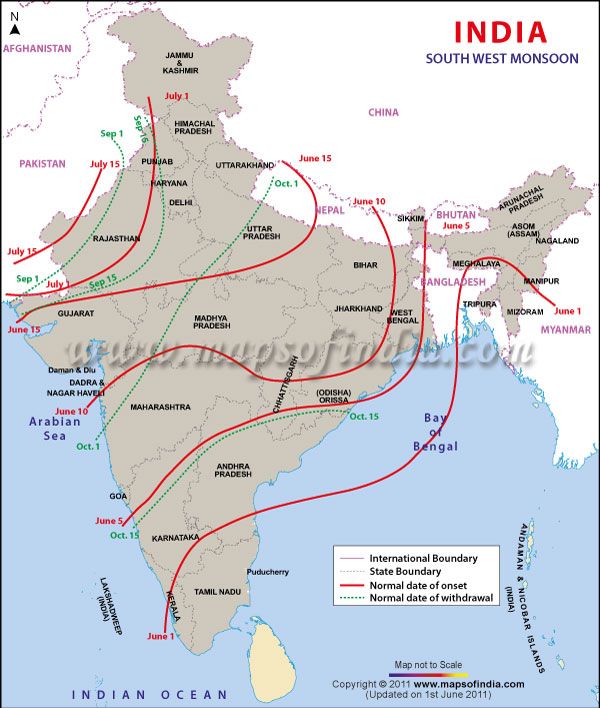
Rain Bearing Systems and Distribution of Rainfall
- The southwest monsoon splits into two branches, the Arabian Sea Branch and the Bay of Bengal Branch near the southernmost end of the Indian Peninsula. Hence, it arrives in India in two branches: the Bay of Bengal branch and the Arabian Sea branch. First originated in the Bay of Bengal causing rainfall over the plains of north India. Second is the Arabian Sea current of the southwest monsoon which brings rain to the west coast of India. The latter extends toward a low-pressure area over the Thar Desert and is roughly three times stronger than the Bay of Bengal branch.
- The monsoon winds originating over the Arabian Sea further split into three branches:
- A. One branch is obstructed by the Western Ghats. These winds climb the slopes of the Western Ghats and as a result of the orographic rainfall phenomenon, the windward side of Ghats receives very heavy rainfall ranging between 250 cm and 400 cm. After crossing the Western Ghats, these winds descend and get heated up. This reduces humidity in the winds. As a result, these winds cause little rainfall east of the Western Ghats. This region of low rainfall is known as the rain-shadow area.
- B. Another branch of the Arabian Sea monsoon strikes the coast north of Mumbai. Moving along the Narmada and Tapi river valleys, these winds cause rainfall in extensive areas of central India. The Chotanagpur plateau gets 15 cm of rainfall from this part of the branch. Thereafter, they enter the Ganga plains and mingle with the Bay of Bengal branch.
- C. A third branch of this monsoon wind strikes the Saurashtra Peninsula and the Kutch. It then passes over west Rajasthan and along the Aravallis, causing only a scanty rainfall. In Punjab and Haryana, it too joins the Bay of Bengal branch. These two branches, reinforced by each other, cause rains in the western Himalayas.
- The intensity of rainfall over the west coast of India is, however, related to two factors:
- The offshore meteorological conditions.
- The position of the equatorial jet stream along the eastern coast of Africa.
- The Bay of Bengal branch strikes the coast of Myanmar and part of southeast Bangladesh. But the Arakan Hills along the coast of Myanmar deflect a big portion of this branch towards the Indian subcontinent. The monsoon, therefore, enters West Bengal and Bangladesh from the south and southeast instead of from the south-westerly direction. From here, this branch splits into two under the influence of the Himalayas and the thermal low is northwest India.
- One branch moves westward along the Ganga plains reaching as far as the Punjab plains. The other branch moves up the Brahmaputra valley in the north and the northeast, causing widespread rains. Its sub-branch strikes the Garo and Khasi Hills of Meghalaya. Mawsynram, located on the crest of Khasi hills, receives the highest average annual rainfall in the world.
- The Tamil Nadu coast remains dry during this season because it is situated in the rainshadow area of the Arabian Sea branch of the southwest monsoon and lies parallel to the Bay of Bengal branch of the southwest monsoon.
- The frequency of tropical depressions originating over the Bay of Bengal varies from year to year. The path of these depressions also keeps changing with the position of the ITCZ, also known as the monsoon trough (Figure – position of Inter-tropical Convergence Zone (ITCZ) in the month of January and July). As the axis of the monsoon trough oscillates with the apparent movement of the sun between Tropic of Cancer and Tropic of Capricorn, there are fluctuations in the track and direction of these depressions, and the intensity and the amount of rainfall vary from year to year. The amount of rainfall in north India varies with the frequency of the tropical depressions. On average, one to three depressions are observed every month and the life span of one depression is about one week.
- The rain which comes in spells displays a declining trend from west to east over the west coast, and from the southeast towards the northwest over the North Indian Plain and the northern part of the Peninsula. Rajasthan desert receives low rainfall in spite of being in the path of the Arabian Sea branch of the monsoon. This branch blows parallel to the Aravalis mountain chain without obstruction and thus, does not release moisture here.
Break in the Monsoon
- During the southwest monsoon period after having rained for a few days, if rain fails to occur for one or more weeks, it is known as a break in the monsoon. These dry spells are quite common during the rainy season. These breaks in the different regions are due to different reasons:
- In northern India rains are likely to fail if the rain-bearing storms are not very frequent along the monsoon trough or the ITCZ over this region.
- Over the west coast the dry spells are associated with days when winds blow parallel to the coast.
Retreating/Post Monsoons (The Transition Season)
- During October-November, with the apparent movement of the sun towards the south, the monsoon trough or the low-pressure trough over the northern plains becomes weaker. This is gradually replaced by a high-pressure system. The southwest monsoon winds weaken and start withdrawing gradually. By the beginning of October, the monsoon withdraws from the Northern Plains. The months of October November form a period of transition from hot rainy season to dry winter conditions. The retreat of the monsoon is marked by clear skies and a rise in temperature. While day temperatures are high, nights are cool and pleasant. The land is still moist. Owing to the conditions of high temperature and humidity, the weather becomes rather oppressive during the day. This is commonly known as ‘October heat’. In the second half of October, the mercury begins to fall rapidly in northern India.
- The low-pressure conditions, over northwestern India, get transferred to the Bay of Bengal by early November. This shift is associated with the occurrence of cyclonic depressions, which originate over the Andaman Sea. These cyclones generally cross the eastern coasts of India cause heavy and widespread rain. These tropical cyclones are often very destructive. The thickly populated deltas of the Godavari, the Krishna, and the Kaveri are frequently struck by cyclones, which cause great damage to life and property. Sometimes, these cyclones arrive at the coasts of Orissa, West Bengal, and Bangladesh. The bulk of the rainfall of the Coromandel Coast is derived from depressions and cyclones.
Features of Monsoon Rainfall
- Monsoon rain is seasonal in character which occurs between June and September.
- Spatial distribution of rainfall is largely governed by relief or topography. For instance the
windward side of the Western Ghats registers a rainfall of over 250 cm. Again, the heavy
rainfall in the northeastern states can be attributed to their hill ranges and the Eastern
Himalayas. Rainfall ranges from 20 cm in western Rajasthan to more than 400 cm in
certain parts of Western Ghats and North-East India. - The monsoon rainfall has a declining trend with increasing distance from the sea. Rainfall decreases from east to west in plains as one branch of monsoon enters from eastern side. Kolkata receives 119 cm, Allahabad 76 cm and Delhi 56 cm only.
- Breaks (discussed above) in rainfall are related to the cyclonic depressions mainly formed at the head of the Bay of Bengal, and their crossing into the mainland. Besides the frequency and intensity of these depressions, the passage followed by them determines the spatial distribution of rainfall.
- The rains sometimes end considerably earlier than usual, causing great damage to standing crops and making the sowing of winter crops difficult.
Monsoons and the Economic Life in India
- Monsoon is that axis around which revolves the entire agricultural cycle of India. It is because about 64 percent of people of India depend on agriculture for their livelihood and agriculture itself is based on the southwest monsoon.
- Except Himalayas all the parts of the country have temperatures above the threshold level to grow the crops or plants throughout the year.
- Regional variations in monsoon climate help in growing various types of crops.
- Agricultural prosperity of India depends very much on time and adequately distributed rainfall. If it fails, agriculture is adversely affected mainly in areas where irrigation is not developed.
- Sudden monsoon burst creates the problem of soil erosion over large areas in India.
Monsoon as unifying factors:
- It is already known the way the Himalayas protect the subcontinent from extremely cold winds from central Asia. This enables northern India to have uniformly higher temperatures when compared to other areas on the same latitudes. Similarly, the peninsular plateau, under the influence of the sea from three sides, has moderate temperatures. Despite such moderating influences, there are great variations in the temperature conditions. Nevertheless, the unifying influence of the monsoon on the Indian subcontinent is quite perceptible. The seasonal alteration of the wind systems and the associated weather conditions provide a rhythmic cycle of seasons. Even the uncertainties of rain and uneven distribution are very much typical of the monsoons. The Indian landscape, its animal and plant life, its entire agricultural calendar, and the life of the people, including their festivities, revolve around this phenomenon. Year after year, people of India from north to south and from east to west, eagerly await the arrival of the monsoon. These monsoon winds bind the whole country by providing water to set the agricultural activities in motion. The river valleys which carry this water also unite as a single river valley unit.

0 Comments