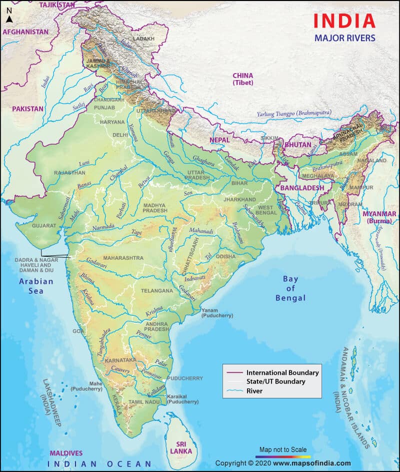
In this article, You will read Godavari River System – UPSC IAS.
Godavari River System
- The Godavari river is the largest river in Peninsular India. It is known as the Dakshin Ganga or Vridha Ganga (old Ganga) because of its age, size, and length. It is navigable in the delta region.
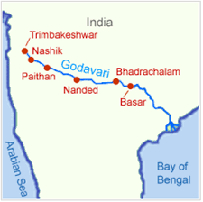
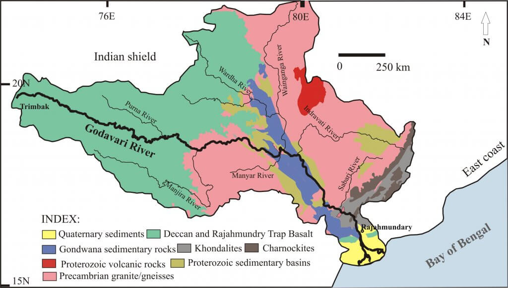
- Source of origin of the Godavari river: It rises from a place called Trimbak located in the Western Ghats in Nashik district in the state of Maharashtra.
- Confluence or mouth of the Godavari river: It drains into the Bay of Bengal before forming a large delta below Rajahmundry.
- The Godavari basin extends over states of Maharashtra, Andhra Pradesh, Chhattisgarh, and Odisha in addition to smaller parts in Madhya Pradesh, Karnataka, and the Union Territory of Puducherry (Yanam) having a total area of ~ 3 lakh Sq.km.
- The basin is bounded by Satmala hills, the Ajanta range, and the Mahadeo hills on the north, by the Eastern Ghats on the south and the east, and by the Western Ghats on the west.
- The total length of Godavari from its origin to outfall into the Bay of Bengal is 1,465 km.
- Rajahmundry is the largest city on the banks of Godavari.
- The Sri Ram Sagar project which was constructed on this river (1964-69) serves the irrigation needs of Adilabad, Nizamabad. Karimnagar and Warangal districts.
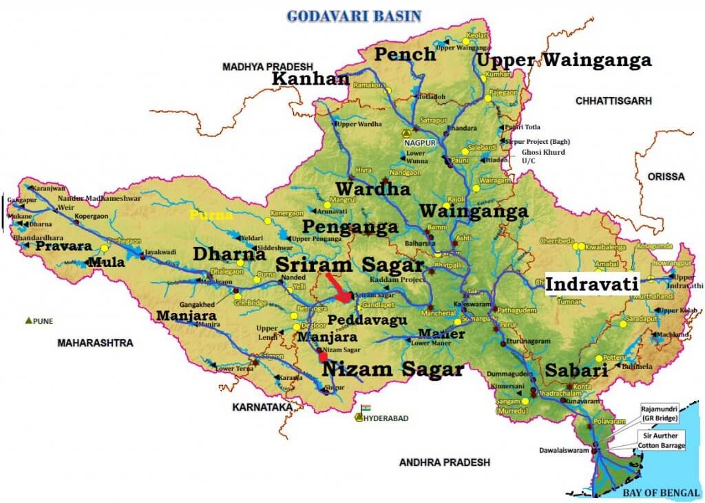
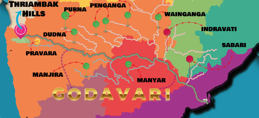
- The Pravara, Indravati, Wainganga, Wardha, Pench, Kanhan, Penganga, Manjira, Bindusara and sabari rivers are its important tributaries.
- Nashik, Trimbakeshwar, Nanded, Aurangabad, Nagpur, Bhadrachalam, Nizamabad, Rajamundry, Balaghat, Yanam, and Kovvur are the important urban centers on its bank.
Tributaries of Godavari River
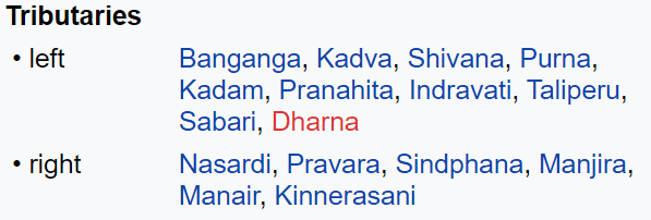
- The left bank tributaries are more in number and larger in size than the right bank tributaries.
- The Manjra (724 km) is the only important right-bank tributary. It joins the Godavari after passing through the Nizam Sagar.
- Left Bank Tributaries: Dharna, Penganga, Wainganga, Wardha, Pranahita [conveying the combined waters of Penganga, the Wardha and Wainganga], Pench, Kanhan, Sabari, Indravati etc.
- Right Bank Tributaries: Pravara, Mula, Manjra, Peddavagu, Maner etc.
- Below Rajahmundry, the river divides itself into two main streams, the Gautami Godavari on the east and the Vashishta Godavari on the west, and forms a large delta before it pours into the Bay of Bengal.
- The delta of the Godavari is of lobate type with a round bulge and many distributaries.
MANJRA
- It is a right-bank tributary of the river Godavari.
- It originates in the Balaghat range, near Ahmednagar, at an altitude of 823 m.
- Manjra River flows through the Latur District of Maharashtra and the Bidar District of Karnataka before entering Medak District in Andhra Pradesh.
- It flows for about 96km in Medak District through Narayankhed, Jahirabad. Sangareddy and Narsapur Talukas.
- Ultimately, it drains into the Godavari River at Basara near Nizamabad.
- Valdi river is a tributary of Marijira, Nizam Sagar was constructed across the Manjra River between Achampeta and Banjapalle villages of the Niamabad district in Andhra Pradesh.
- The most outstanding feature of the project is the gigantic masonry dam sprawling across the river for 3km with a motorable road of 14feet width.
PAINGANGA
- (Penganga or Panuganga) It originates in the Ajantha ranges in the Aurangabad district in Maharashtra.
- It then flows through Buldhana and Washim districts.
- Then it acts as a boundary between Yavatma and Nanded districts.
- It then flows along the state border between Maharashtra and AP.
- It joins the Wardha River near a small village called Wadha in Wani Tehsil of Yavatmal district
- It is deeply entrenched and not able to be navigated.
- The river provides irrigation to the Washim and Yavatmal districts in Maharashtra.
- There are two dams being constructed on the river, namely Upper Painganga and Lower Painganga.
- Also, this dam is known as the “Isapur Dam”.
- Adan river is the major tributary.
- It passes through the Painganga Wildlife Sanctuary.
- Sahastrakund waterfalls are situated on it.
WARDHA
- It is one of the biggest rivers in the Vidarbha region of Maharashtra.
- It originates at an altitude of 777 meters in Satpura Range near Multai in Betul District of Madhya Pradesh, about 70 miles north-west of Nagpur
- From the origin, it flows 32 km in Madhya Pradesh and then enters into Maharastra
- After traversing 528km, it joins Wainganga and together they are called Pranhita, which ultimately flows into the Godavari River
- Kar, Wena, Jam, Erai are the left tributaries
- Madu, Bembla. Penganga are the right tributaries
- A huge dam (Upper Wardha Dam) is built on Wardha River near Morshi and considered a lifeline for Amravati city.
WAINGANGA
- It literally means “the arrow of water“.
- It originates about 12 km, from Mundara village of Sconi district in the southern slopes of the Mahadeo Hills of the Satpura Range of Madhya Pradesh and flows south through Madhya Pradesh and Maharashtra in a very winding course of approximately 4 360 miles
- After joining the Wardha, the united stream, known as the Pranahitha, ultimately falls into the river Godavari.
- It drains the Chandrapur. Gadchiroli, Bhandara, Gondia, and Nagpur districts of Maharashtra.
- The main tributaries of the Wainganga River are the Thel, Thanwar, Bagh, Chulband, Garhavi, Khobragadi, and Kathani, which meet on the left bank; and the Hirri, Chandan, Bawanthari, Kanhan, and Mul joining on the right bank.
- Kamptee, Bhandara, Tumsar, Balaghat, and Pauna are the major urban and industrial centers along the river.
Nag River
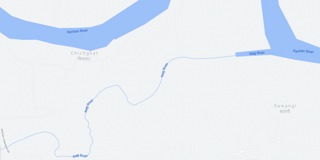
- The Nagpur city derives its name from the Nag river which passes through the city.
- The Nag river originates from the Ambazari Lake in west Nagpur.
- Major Tributaries – Pili river.
- Endpoint – confluence with Kanhan River, and further Kanhan River confluence with Pench river and Forming a Kanhan-Pench river system.
- The Kanhan River is an important right-bank tributary of the Wainganga River draining a large area lying south of the Satpura range in central India.
INDRAVATI
- Indravati River originates from Thuamul Rampur rises in the Eastern Ghats in Kalahandi in Orissa.
- Then it flows through Bastar District in Chhattisgarh for about 380km
- While in Bastar, Indravati is the largest and the most significant.
- It also forms the boundary between Maharashtra and Chhattisgarh states at places.
- Later this river merges with the Godavari River at Bhadrakali in Dantewada District.
- The Indravati is sometimes known as the lifeline of the Bastar district.
- The rocky bedded river is not good for navigation except near its confluence with the Godavari.
- The largest tributary of the river is Pamer Chinta.
- Indravati and her tributaries never dry up in summer.
- The Chitrakoot Falls is located on the Indravati River, some 40lm from Jagdalpur.
- Indravati National Park and Tiger Reserves are located in the adjoining region of Chattisgarh.
Projects on Godavari River
- Important projects completed duing the plan period are Srirama Sagar, Godavari barrage, Upper Penganga, Jaikwadi, Upper Wainganga, Upper Indravati, Upper Wardha.
- Among the on-going projects, the prominent ones are Prnahita-Chevala and Polavaram.
Industry in Godavari Basin
- The major urban Centers in the basin are Nagpur, Aurangabad, Nashik, Rajhmundry.
- Nashik and Aurangabad have a large number of industries especially automobiles.
- Other than this, the industries in the basin are mostly based on agricultural produce such as rice milling, cotton spinning and weaving, sugar, and oil extraction.
- Cement and some small engineering industries also exist in the basin.
Floods and Droughts in Godavari Basin
- Godavari basin faces flooding problems in its lower reaches.
- The coastal areas are cyclone-prone.
- The delta areas face drainage congestion due to flat topography.
- A large portion of Maharashtra falling (Marathwada) in the basin is drought-prone.
Godavari and Cauvery River Interlinking Project
- The project envisages the diversion of 247 thousand million cubic feet (tmcft) of unutilized water in the Indravati sub-basin of the Godavari basin to meet the requirements between the Godavari and the Cauvery rivers.
- Water will be diverted from the Godavari River to Nagarjuna Sagar dam (through lifting) and further south to meet the demands of Krishna, Pennar, and Cauvery basins.
- The Godavari – Cauvery link comprises three components namely,
- the Godavari (Inchampalli/Janampet) – Krishna (Nagarjunasagar),
- the Krishna (Nagarjunasagar) – Pennar (Somasila) and
- the Pennar (Somasila)–Cauvery.
- The project will provide irrigation facilities to 3.45 to 5.04 lakh hectares in the Prakasam, Nellore, Krishna, Guntur, and Chittoor districts of Andhra Pradesh.
